Contact Us

Use the form on the right to contact us.

You can edit the text in this area, and change where the contact form on the right submits to, by entering edit mode using the modes on the bottom right. 


123 Street Avenue, City Town, 99999

(123) 555-6789

email@address.com


You can set your address, phone number, email and site description in the settings tab.
Link to read me page with more information.

backlit-stratus-clouds-2013-04-05.jpg

Blog

Weather forecasting and analysis, space and historic events, climate information

Filtering by Category: DC

6:00 AM | ***"Clipper" accumulating snow today...major coastal storm threat for early this weekend***

Paul Dorian

6-Day Forecast

Today

Cloudy, cold, snow develops by mid-to-late morning and continues this afternoon, there can be some rain or sleet mixed in briefly at the onset and then again late in the day, accumulations on the order of 1-3 inches in the District and points to the north, lesser amounts south of the District, highs in the mid 30’s

Tonight

Mainly cloudy, cold, snow ends early, possibly followed by a period of freezing drizzle, lows in the mid-to-upper 20’s

Thursday

Partly sunny, breezy, chilly, low 40’s

Thursday Night

Partly cloudy, cold, mid 20’s

Friday

Mostly sunny, cold, near 40 degrees

Saturday

Major storm potential...Mostly cloudy, cold, chance for snow or a combination of snow and rain, upper 30’s

Sunday

Partly sunny, cold, near 40 degrees

Monday

Mostly cloudy, cold, chance for snow, upper 30’s

Discussion

A “clipper” system is spreading snow into the Mid-Atlantic region this morning and accumulations of 1-3 inches are likely in the District and areas to the north by early tonight. The “clipper” system will intensify as it reaches the relatively warm waters of the western Atlantic Ocean and this could result in an enhanced snowfall later today across central Delaware and southern New Jersey where 3-5 inches can accumulate. The snow can be briefly mixed with rain or sleet at the onset and then there can be a period of freezing drizzle this evening after the snow winds down.

Looking ahead, another storm could affect the region early this weekend and this one carries much more potential as it would be of the “coastal” variety with considerably more in the way of moisture. It is still too early to tell if the precipitation from this storm would be snow or a mixture of rain and snow in the I-95 corridor as temperatures will be only marginally cold; however, the potential does exist for significant snow accumulations. Another storm may follow quickly by early next week.

Video

httpv://youtu.be/kbYAyPHnj7U

1:15 PM | **"Clipper" snow on Wednesday...major coastal storm threat for Saturday**

Paul Dorian

Discussion

An all-out snowstorm is on the table for the I-95 corridor region from DC-to-Boston this weekend, but that system is several days away and we have to deal with a “clipper” system in the short-term. A fast-moving “clipper” system is indeed dropping southeastward today from the Northern Plains towards the Mid-Atlantic region and accumulating snow is likely tomorrow across much of the I-95 corridor. This low pressure system will intensify quickly upon reaching the relatively warm coastal waters of the western Atlantic Ocean and this could enhance snowfall amounts in Delaware and southern New Jersey late Wednesday. The specifics on the forecast for tomorrow by region follow:

DC Accumulations of a coating to a couple of inches possible in the District and points to the north…little or no accumulations are expected in the nearby locations just to the south of the District. Snow begins early tomorrow morning and can be mixed with rain at times; especially, just to the south and east of the District. The heaviest snow should come in the period from mid-to-late morning through mid-afternoon. Precipitation winds down late tomorrow afternoon. The morning commute can be impacted by this weather scenario and there can be some residual effects on the evening commute.

Philly Accumulations of a coating to a couple of inches are possible by late tomorrow evening. Snow begins during the mid-to-late morning hours and continues into the evening. Rain can mix in at the onset in areas from Philly south and east, but this should become primarily a snow event. The morning commute is likely to take place before the main action begins, but the evening commute will likely be negatively impacted by the weather. Even higher snowfall amounts are possible across Delaware and South Jersey (perhaps 4 inches or so).

NYC Accumulations of a coating to an inch or so are possible in and around the NYC metro region. Snow is likely in the time period from mid-day into early tomorrow night. The morning commute is likely to take place before the main action begins, but the evening commute will likely be negatively impacted by the weather.

Looking ahead There could be a blockbuster coastal storm this weekend and then another storm threatens the Mid-Atlantic region during the early part of next week. If you are a snow lover, then one of the potential problems with the weekend storm is the fact that there will not be an Arctic air mass in place anchored by strong high pressure - usually a requirement for a snowstorm around these parts. However, it is possible for a strong storm to “generate” its own cold air and that could end up being the case here. Stay tuned, still a long way to go.

12Z_GFS_Sat_early_PM 
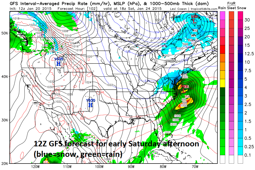
[12Z GFS forecast map for early Saturday afternoon; courtesy tropicaltidbits.com]

7:00 AM | **"Clipper" system to affect the region on Wednesday...accumulating snow threat has shifted southward into DC region**

Paul Dorian

6-Day Forecast

Today

Partly sunny, chilly, a couple of snow or rain showers possible, highs in the mid 40’s

Tonight

Mainly cloudy, cold, rain or snow shower possible early then chance for snow and/or rain towards morning, lows near 30 degrees

Wednesday

Mostly cloudy, cold, snow likely, possibly mixed with rain at times; especially south and east of DC, snow accumulations of a coating to a couple of inches are possible from the District north and west, little or no snow accumulation is expected in the nearby sections just to the south and east of the District, near 40 degrees

Wednesday Night

Mostly cloudy, cold, mid 20’s

Thursday

Mostly sunny, breezy, a bit colder, mid-to-upper 30’s

Friday

Partly sunny, cold, upper 30’s

Saturday

Partly sunny, cold, chance for rain or snow, near 40 degrees

Sunday

Partly sunny, chilly, low 40’s

Discussion

A “clipper” system is dropping southeastward today across the Northern Plains and Upper Midwest and it will reach the Mid-Atlantic coastline later tomorrow. As this system reaches the Mid-Atlantic coastline on Wednesday, it will intensify somewhat and grab additional moisture from off of the Atlantic Ocean. There may be some precipitation around here towards morning, but the best chance will be from mid-morning through the afternoon hours. Rain can mix in at times during this event; especially, on the south and east side of the District, but the threat does exist for snow accumulations on the order of a coating to a couple of inches in the District and points north and west. The overall weather pattern becomes quite active beginning with this system and there are a couple of other storm threats - potentially big ones - coming this weekend and early next week.

Video

httpv://youtu.be/s9Q4ijXxDqI

7:00 AM | Moderate chill to start the new week..."clipper" system threatens by mid-week

Paul Dorian

6-Day Forecast

Today

Partly sunny, becoming breezy, chilly, flurries are possible across northern sections this morning, highs in the low 40's

Tonight

Mainly clear, breezy, cold, lows in the upper 20’s

Tuesday

Mainly cloudy, chilly, low 40’s

Tuesday Night

Cloudy, cold, chance for snow or rain late, low 30’s

Wednesday

Mostly cloudy, chilly, chance for snow and/or rain showers, low 40’s

Thursday

Becoming partly sunny, breezy, a bit colder, upper 30's

Friday

Partly sunny, cold, upper 30’s

Saturday

Partly sunny, cold, upper 30’s

Discussion

Yesterday’s coastal storm has departed to the northeast and a moderately cold air mass has moved into the Mid-Atlantic region in its wake. It’ll stay moderately cold for much of this week and we’ll be watching a “clipper” system as it drops southeastward across the northern Plains and Upper Midwest over the next 24 hours and reaches the Northeast US at mid-week. This system will likely spread some snow and/or rain into the DC metro region on Wednesday and it will then reinforce the cold air around here for the latter part of the week.

Video

httpv://youtu.be/7BJ7hCYZJlI

2:45 PM | Scattered snow showers accompany Arctic blast...an update on Sunday's coastal storm (a tricky forecast)...Comet Lovejoy

Paul Dorian

gfs_namer_060_500_vort_ht
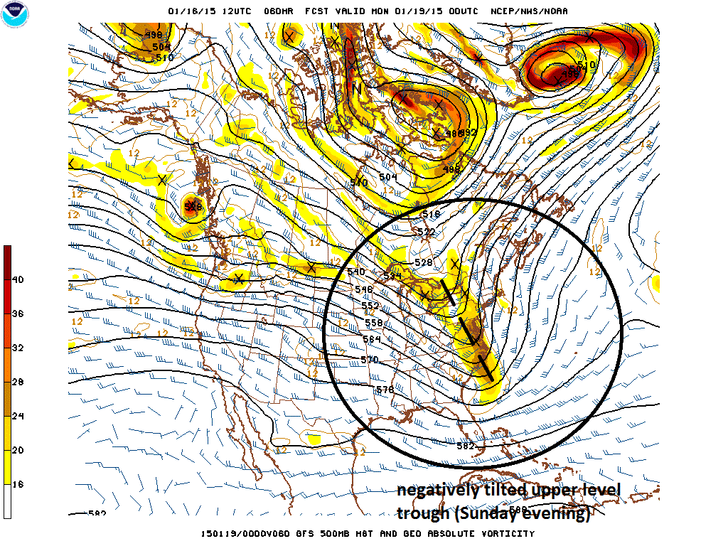
[12Z GFS 500 millibar forecast map for Sunday evening; courtesy NOAA]

Discussion

Scattered snow showers today near Philly, NYC, brutal tonight Arctic air is pouring into the region this afternoon on gusty NW winds and scattered snow showers are accompanying this influx of cold air. These scattered snow showers are possible over the next few hours; especially, in the northern and western suburbs of Philly and NYC where visibilities can drop quickly for a brief time. Temperatures tonight will plunge way down into the low-to-middle teens in most of these suburban locations and will stay well below normal on Saturday.

Coastal storm on Sunday with a freezing rain threat at the onset A coastal storm will develop near the Carolina coastline on Sunday at the same time another area of low pressure will be crossing the Great Lakes region. The developing coastal storm will spread significant precipitation into the I-95 corridor region from DC-to-Philly-to-NYC during Sunday morning and then that will continue in the afternoon and evening. The upper-level trough associated with this coastal storm will start to negatively tilt late Sunday (above) and this has the potential to enhance the precipitation for a period of time most from around Philly to points north and east. Ultimately, the southern low pressure system absorbs the northern low and becomes quite a storm for New England by late Sunday night and early Monday.

As far as temperatures and precipitation type are concerned – the tricky part of the forecast - Sunday will be cold at the start, but there should be some warm advection at low-levels of the atmosphere resulting in eventual above-freezing surface temperatures. The upper atmosphere, however, will tend to gradually cool down on Sunday and, all in all, cold air will stay pretty close to the I-95 corridor during much of the storm and will wrap in quickly behind as it departs to the northeast. As a result, freezing rain is possible at the onset; especially, in higher elevation areas to the north and west of I-95. Also, there can be a brief changeover to snow and/or sleet towards the end of the storm as it pulls away to the northeast. It stays moderately cold next week and we’ll likely have to deal with a “clipper” type of system at mid-week with some snow possible in parts of the Mid-Atlantic region.

Comet Lovejoy Finally, after the scattered snow showers dissipate late today across PA, NJ and NY, skies are likely to clear nicely tonight and it may be a good opportunity to view Comet Lovejoy (although very cold) which is now reaching its maximum brightness. The comet is now in the vicinity of the Pleiades star cluster (see image below).

lovejoy 
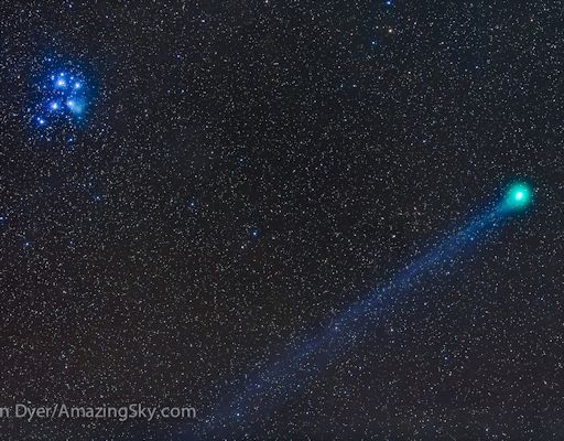
[Recent image of Comet Lovejoy; courtesy spaceweather.com]

7:00 AM | Gusty winds today as another cold air mass moves in...upper teens possible late tonight to the N and W

Paul Dorian

6-Day Forecast

Today

Mostly sunny, becoming windy, cold, highs not far from 40 degrees

Tonight

Mainly clear, breezy, very cold, lows near 20 degrees

Saturday

Mainly sunny, cold, mid-to-upper 30’s

Saturday Night

Partly cloudy, cold, low 30's

Sunday

Becoming cloudy, milder, chance for rain, mid 40’s

Monday

Becoming partly sunny, breezy, colder, near 40 degrees

Tuesday

Mainly sunny, cold, upper 30’s

Wednesday

Partly sunny, cold, snow showers possible, near 40 degrees

Discussion

A cold front will push through our area early today reinforcing our cold weather pattern and the winds will pick up noticeably post frontal system. Temperatures should struggle to reach 40 degrees today and then will drop sharply overnight into the upper teens in some suburban locations. After a cold day on Saturday, it’ll turn milder on Sunday as a storm forms near the east coast. Rain is possible here on Sunday and there can even be some snow involved with this system both at the onset and then again at the end, but there also remains a chance that the entire precipitation field misses us just to our east. Nonetheless, colder air will follow the coastal storm for the first half of next week and we may have to deal with a "clipper" system at mid-week.

7:00 AM | Still quite chilly as we wind down the work week and begin the weekend...some rain is possible later Sunday with a coastal storm...colder again early next week

Paul Dorian

6-Day Forecast

Today

Partly sunny, cold, highs in the upper 30’s

Tonight

Partly cloudy, cold, lows in the mid 20’s

Friday

Mainly sunny, breezy, cold, upper 30’s

Friday Night

Partly cloudy, quite cold, low 20’s

Saturday

Mainly sunny, still cold, near 40 degrees

Sunday

Becoming cloudy, milder, chance for PM rain, mid-to-upper 40’s

Monday

Partly sunny, breezy, colder, upper 30’s

Tuesday

Partly sunny, cold, upper 30’s

Discussion

High pressure to our west will edge into the region today and take control of the weather as we close out the work week and begin the weekend. It’ll stay colder-than-normal today and then a reinforcing cold front will keep us on the cold side of normal both tomorrow and Saturday along with some gusty winds. A coastal storm is likely to develop on Sunday and it could produce rain around here later in the day and again on Sunday night. Colder air moves into the Mid-Atlantic region for the first half of next week in the wake of the coastal storm. In fact, there is no long-term or dramatic warmup coming anytime soon to the Northeast US despite some rumors to the contrary - the overall cold pattern will continue.

6:00 AM | *Snow early this morning can accumulate a coating to an inch primarily south and east*

Paul Dorian

6-Day Forecast

Today

Mostly cloudy and cold with snow likely early today primarily on the south and east side of the metro region, accumulations of a coating to an inch possible highs near 30 degrees

Tonight

Mostly cloudy, quite cold, lows in the low-to-mid 20’s

Thursday

Partly sunny, cold, mid-to-upper 30’s

Thursday Night

Partly cloudy, cold, mid 20’s

Friday

Partly sunny, not as cold, low 40’s

Saturday

Mostly sunny, chilly, low 40’s

Sunday

Mostly cloudy, milder, chance for rain, upper 40’s

Monday

Partly sunny, chilly, mid 40’s

Discussion

An area of moisture near the Mid-Atlantic coastline is combining with upper level energy to produce some snow in parts of the Mid-Atlantic region this morning and there is likely to be accumulations on the order of a coating to an inch in the District and on the south and east side of the metro region and also across the Delmarva Peninsula and southern New Jersey. Sleet can mix in at times today just to the south and east of DC and especially near coastal sections of the Delmarva Peninsula, but whatever falls in and around the District should primarily be in the form of snow.

Looking ahead, after a couple of cold and tranquil days to close out the work week it'll turn (briefly) milder late this weekend. A coastal storm threatens for later Sunday which would likely generate rain in the I-95 corridor and this would then be followed by colder air for the early part of next week. There is no long-term or dramatic warmup coming anytime soon to the Northeast US despite some rumors to the contrary. By the middle of next week, we may have to deal with a "clipper" type of system dropping southeastward across the northern Plains and Upper Midwest.

Video

httpv://youtu.be/GFJZ4041Sd0

12:30 PM | **Interesting features on today’s visible satellite image and an update on the sneaky accumulating snow threat for tomorrow**

Paul Dorian

satellite
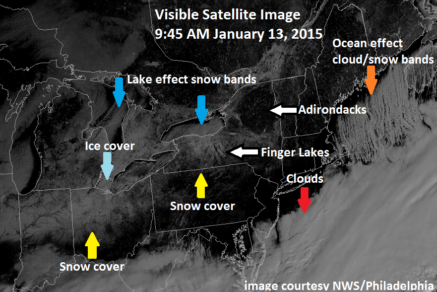
[Morning visible satellite image with numerous interesting features; courtesy National Weather Service/Philadelphia; NOAA]

Discussion

Visible satellite image and some interesting features Satellite images are extremely valuable in the world of weather forecasting and this morning’s GOES visible image has several interesting features in the Great Lakes region, Ohio Valley and Northeast US. First, clear skies exist in the I-95 corridor region from DC-to-Philly-to-NYC and these cloud-free conditions should last into the early part of tonight allowing for the possibility of viewing Comet Lovejoy (see posting at http://vencoreweather.com/2015/01/13/1050-am-an-update-on-comet-lovejoy-now-in-its-best-two-weeks/). However, thick clouds can be seen on the satellite image just to the south and east of DC and they will advance northward later tonight associated with an area of moisture that may produce some snow around here on Wednesday (see below). Elsewhere, snow cover can be seen across northern Indiana and northern Ohio as well as in New York State, and geographical features like the Finger Lakes and Adirondacks Mountains become quite noticeable with clear skies and surrounding snow cover.

In addition, a northerly wind is generating “lake-effect” snow bands that are dropping southward from Lake Ontario into western New York State and the same atmospheric pattern is generating cloud and snow bands just downwind of Maine (for more on the “lake-effect” snow phenomenon check out video #20 on our Meteo 101 page: http://vencoreweather.com/meteorology-101/). Finally, ice cover is starting to expand quite rapidly in the Great Lakes and given the current cloud-free skies, some of this is visible on today's visible satellite image over western Lake Erie (the shallowest of the Great Lakes which often freezes early). Let me add that the best way to confirm that these surface features are real (ice cover, snow cover, etc.) is to look at a loop of visible satellite images which can be done at the Penn State eWall web site: http://mp1.met.psu.edu/~fxg1/SAT_NE/anim8vis.html).

Sneaky snow threat for Wednesday in parts of the Mid-Atlantic region Accumulations of snow are on the table for parts of the Mid-Atlantic region on Wednesday; especially, in the region from the DC metro region-to-southern New Jersey and cutting across the Delmarva Peninsula where a coating to an inch or two can fall. Some light snow accumulations can even occur as far north and east as the Philly and NYC metro regions, but higher chances do exist just to the south and east of those areas. The combination of weak upper level energy, increasing low-level east-to-northeast flow off the Atlantic Ocean, and an area of moisture currently sitting over the Carolinas will likely generate some snow accumulations in parts of the Mid-Atlantic region late tonight and Wednesday - likely in time to have an impact on the DC morning commute. Sleet could mix in at times tomorrow to the south and east of DC and especially near coastal sections of New Jersey and the Delmarva Peninsula, but given the influx today of fresh cold, dry Arctic air, primarily snow should fall in and around DC (and in Philly and NYC if it makes it that far). Stay tuned on this as it is a tricky forecast.

nam_mslp_pcpn_frzn_us_9 
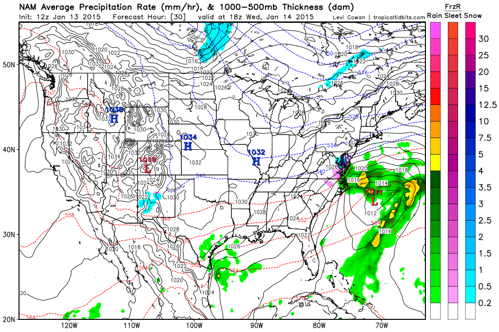
[12Z NAM forecast map for mid-day Wednesday (blue=snow, purple=sleet); courtesy "tropicaltidbits.com"]

7:00 AM | Another very cold air mass for this time of year...sneaky light snow possible tomorrow

Paul Dorian

6-Day Forecast

Today

Becoming partly sunny, breezy and quite cold, temperatures holding nearly steady near 30 degrees

Tonight

Mostly cloudy, very cold, light snow possible late, lows in the upper teens

Wednesday

Mainly cloudy, cold, light snow possible, near 30 degrees

Wednesday Night

Mostly cloudy, quite cold, low 20’s

Thursday

Partly sunny, cold, mid-to-upper 30’s

Friday

Mostly sunny, cold, near 40 degrees

Saturday

Mostly sunny, milder, low-to-mid 40’s

Sunday

Partly sunny, mild, mid-to-upper 40’s

Discussion

Strong, cold high pressure takes control of the weather today and the air mass that is anchored by this high pressure system is quite cold for this time of year. Temperatures today will generally hold steady near the 30 degree mark and overnight lows will plunge to the teens in much of the I-95 corridor. Temperatures will remain below normal on Wednesday and moisture to our south could sneak in and affect parts of the DC metro region with light snow, but it is more likely to fall across the Delmarva Peninsula. Temperatures will moderate later this week making the 40's possible by the upcoming weekend.