Contact Us

Use the form on the right to contact us.

You can edit the text in this area, and change where the contact form on the right submits to, by entering edit mode using the modes on the bottom right. 


123 Street Avenue, City Town, 99999

(123) 555-6789

email@address.com


You can set your address, phone number, email and site description in the settings tab.
Link to read me page with more information.

backlit-stratus-clouds-2013-04-05.jpg

Blog

Weather forecasting and analysis, space and historic events, climate information

Filtering by Category: DC

7:00 AM | ****Weekend accumulating snow, painful cold, dangerous sub-zero wind chills with potential damaging wind gusts past 55 mph or so****

Paul Dorian

6-Day DC Forecast

Today

Mostly sunny, windy, very cold, highs in the mid 20’s with sub-zero wind chills

Tonight

Partly cloudy, winds die down rapidly to calm conditions, very cold, lows in the middle teens

Saturday

Thickening clouds, becoming windy, cold, but not nearly as bitter as today, snow developing during the afternoon hours, mid 30’s

Saturday Night

Occasional snow, becoming extremely windy late, total snow accumulations of a coating to two inches by late night, brutally cold by morning with single digit lows

Sunday

The coldest day of the year so far…painfully cold, extremely windy with dangerous sub-zero wind chills and potential damaging wind gusts past 55 mph or so, highs struggle to reach the middle teens

Monday

A bitter cold start not far from 0 degrees, mostly sunny skies, breezy, still very cold during the afternoon hours with highs struggling to reach the middle 20's

Tuesday

Becoming cloudy, quite cold, snow possible late in the day or at night, mid 30’s

Wednesday

Snow possible early; otherwise, partly sunny, windy, cold, near 30 degrees

Discussion

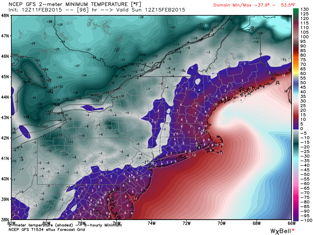
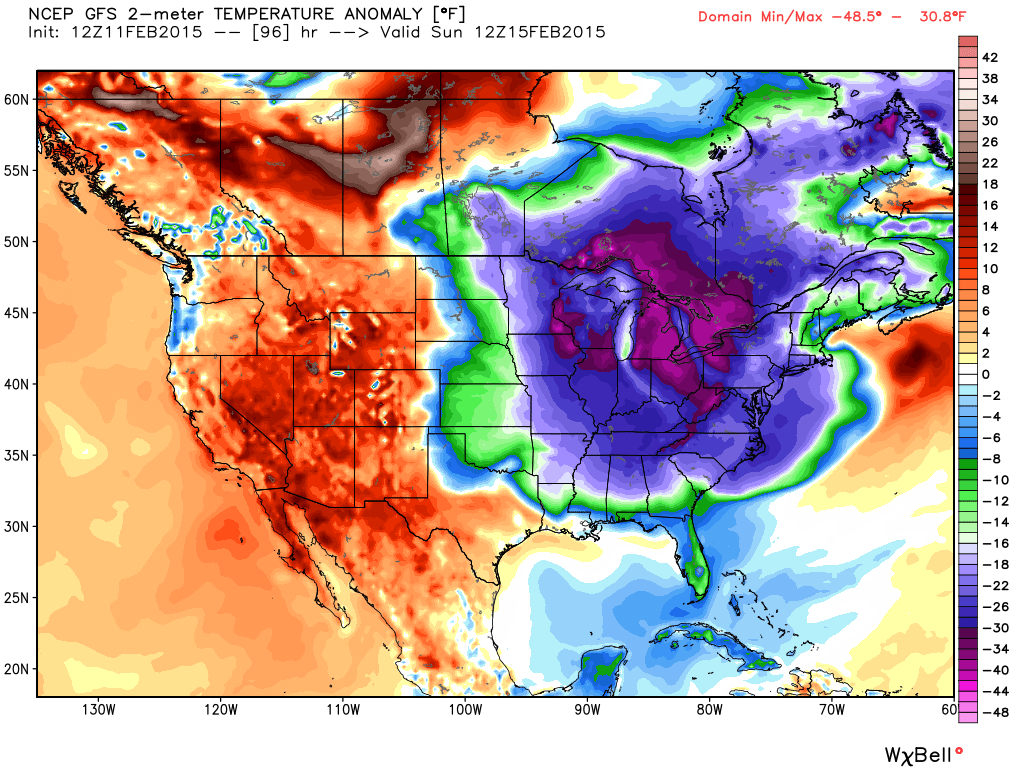
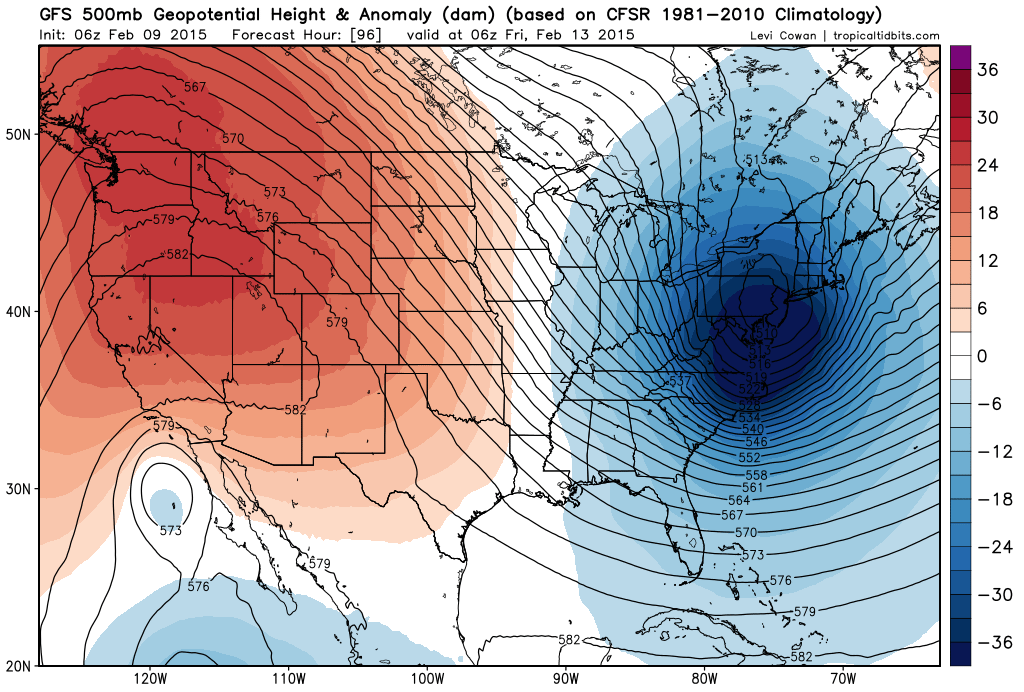
Arctic air has arrived and today promises to be a brutally cold day despite plenty of sunshine along with sub-zero wind chills as winds remain quite strong through much of the day. The winds will relax rapidly this evening, but before this Arctic air mass even has a chance to modify, another one will be fast-approaching as we begin the weekend. By late tomorrow, a clipper system and its associated Arctic front will be dropping southeastward across the Great Lakes region right towards the I-95 corridor. Snow will break out in the afternoon hours and continue at night with a coating to two inches likely by early Sunday.

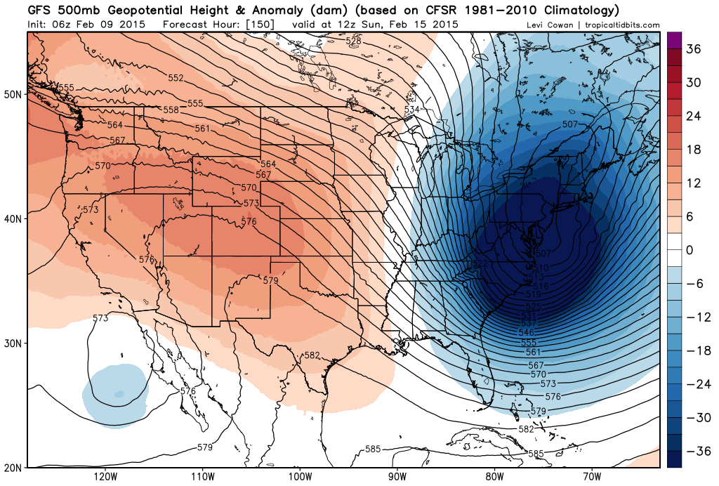
This clipper low pressure system will explode off the Mid-Atlantic coastline late tomorrow and tomorrow night once it passes over the relatively warm waters of the western Atlantic Ocean. This explosive development will lead to a tremendously sharp pressure gradient which will lead to extreme wind gusts around here by late Saturday night and early Sunday on the order of 55 mph or higher. The last thing we need on Sunday - the coldest day of the year so far - is for power outages to develop, but that is definitely on the table for this event so prepare as well as possible. The cold on Sunday will be downright painful and the high winds will cause dangerously low sub-zero wind chill values. This rapidly intensifying storm will produce significant snow once again for New England, and in some ways it will actually be nastier than recent record-setting storms because of the extreme cold and wind that is expected.

Single digits are likely for lows around here on Sunday morning, highs will struggle on Sunday afternoon to even reach the middle teens, and then overnight low temperatures by early Monday morning should drop to near 0 degrees. Another accumulating snow threat will come late Tuesday into Wednesday, but that storm track is still uncertain and it could still end up not being a big problem around here. However, what is certain is that more brutal cold will follow by the middle and latter part of next week - perhaps even on the levels with this Sunday's extreme cold. And for some good news...pitchers and catchers report in just 6 days.

Video

httpv://youtu.be/OQtfYgMWr3I

1:00 PM | ***Friday to Wednesday - the worst weather that winter has to offer***

Paul Dorian

Tues_PM_fcst
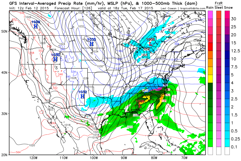
[12Z GFS forecast map for next Tuesday early afternoon (blue=snow); map courtesy "tropicaltidbits.com", NOAA]

Discussion

Overview Get ready; it’s going to be a wild ride. The stretch from Friday to Wednesday will feature some of the worst weather that winter can offer in this part of the country. All of the following are on the table for the 6-day period from tomorrow through next Wednesday:

- Painful cold with 0 degrees within reach (Sunday AM, Monday AM) - Weekend accumulating snow (late Saturday, Saturday night) - Very strong winds with potentially damaging wind gusts (Sunday) - Dangerous sub-zero wind chills (Friday and especially on Sunday) - Significant snow threat (late Tuesday into early Wednesday)

Here are the details: Arctic air arrives today in the Mid-Atlantic region accompanied by snow showers and increasing winds. Those winds will remain strong tonight and temperatures will plunge in the overnight hours into the single digits in many suburban locations by early Friday. The winds remain strong through much of the day on Friday and this will produce sub-zero wind chills at times before the wind finally relaxes noticeably early tomorrow night.

On Saturday, another clipper system and Arctic front will be plowing towards the I-95 corridor from the Great Lakes region. This system has more potential in terms of snowfall in our area compared with today’s frontal system. In fact, snowfall on the order of a coating to two inches is possible late Saturday and Saturday night in the DC metro region, 1-3 inches in Philly, and 2-5 inches in NYC associated with this next Arctic blast. Then, Sunday promises to be the coldest day yet with painful cold, dangerous sub-zero wind chills, and potentially damaging wind gusts past 50 mph. The last thing we need on Sunday is for scattered power outages to develop, but that possibility cannot be ruled out with the most powerful winds likely late Saturday night and early Sunday.

After a bitter cold start on Monday - near 0 degrees in many portions of the I-95 corridor - moisture will begin streaming towards us from the south-central US. The combination of very cold ground temperatures, an entrenched Arctic air mass in the Northeast US and copious amounts of “southern” moisture does not bode well for the Mid-Atlantic region. Indeed, this could turn into a significant snow event for the Mid-Atlantic region from late Tuesday into early Wednesday, but since the storm track cannot be pinned down quite yet, it is just too early to make this call. And yes, this mid-week storm will be followed by more brutal cold.

Buckle up…the next 6 days will be quite interesting.

gfs_late_tues_night 
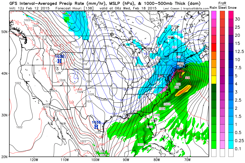
[12Z GFS forecast map for late Tuesday night (blue=snow); map courtesy "tropicaltidbits.com", NOAA]

Video

httpv://youtu.be/7vLfp462510

7:00 AM |**Arctic air arrives overnight and this blast will be followed by another - perhaps the coldest yet - by the time Sunday rolls around**

Paul Dorian

6-Day DC Forecast

Today

Mostly cloudy, becoming windy, cold, scattered snow showers during the mid-day and afternoon hours that can be mixed with rain at the onset, there can even be a brief heavier burst of snow later today with a quick coating of snow possible, highs in the mid-to-upper 30’s

Tonight

Clearing skies, windy and turning brutally cold, lows near 10 degrees with sub-zero wind chills

Friday

Mostly sunny, windy, very cold, low-to-mid 20’s for highs with sub-zero wind chills

Friday Night

Partly cloudy, winds die down, very cold, lows in the mid-to-upper teens

Saturday

Increasing clouds, becoming windy, cold, snow likely late in the day and at night, upper 30’s; brutal cold at night

Sunday

The coldest day of the winter so far…partly sunny, very windy with potential damaging wind gusts, painfully cold, mid-to-upper teens for highs and dangerous sub-zero wind chills

Monday

Mostly sunny, breezy, very cold, mid 20’s for highs after a bitter cold start to the day

Tuesday

Mostly cloudy, quite cold, snow likely, mid 30’s

Discussion

A vigorous Arctic cold front is headed our way and it’ll generate scattered snow showers here during the mid-day and afternoon hours – perhaps even a brief heavier burst of snow with a quick coating possible. Temperatures will plunge in the overnight hours bottoming out near 10 degrees in many suburban locations by early tomorrow morning. Winds will pick up in intensity later today and remain strong through much of Friday generating sub-zero wind chills at times.

Before this Arctic air mass even has a chance to modify, another one will be fast-approaching as we begin the weekend. By late Saturday, a clipper system and its associated Arctic front will be dropping southeastward across the Great Lakes and this will generate some snow in the area later Saturday into Saturday night (a coating to two inches on the table for this event). Brutal cold air will follow this clipper system which will intensify rapidly off the Northeast US coastline once it reaches the relatively warm waters of the western Atlantic Ocean this weekend. In fact, Sunday should turn out to be the coldest day of the winter so far in the eastern US all the way from Maine to Florida and low temperatures on Sunday and Monday could flirt with the 0 degree mark in many I-95 corridor locations. Winds will be very strong on Sunday and could be potentially damaging - power outages are the last thing we need on Sunday, but that possibility cannot be ruled out. Another accumulating snow threat will come Tuesday into Wednesday as tons of “southern” moisture heads right towards the Mid-Atlantic region. This storm could also produce significant ice and perhaps even plain rain in the area...just too early to make that call yet.

Video

httpv://youtu.be/7vLfp462510

1:30 PM | **Back-to-back Arctic invasions to produce amazing cold around here by early Sunday**

Paul Dorian

GFS_Sun_am_lows

Discussion

Overview The normal high temperature for today at Philly’s International Airport is 43 degrees and we are going to end the day several degrees below that mark, but this cold is nothing compared to the type of cold that is coming. Back-to-back Arctic invasions will send temperatures plummeting in the Mid-Atlantic region over the next few days and the second blast is likely to feature the coldest air of the season so far in much of the area from Maine to Florida. The last time temperatures dropped to less than 10 degrees in Philly during the month of February was in 1996 (6 degrees on 2/6/96). There is little doubt that Philly will see temperatures that low on Sunday morning (and again on Monday morning). The last time sub-zero readings occurred in Philly during the month of February was in 1979 (-2 degrees on 2/11/79) and this is not out of the question for the Sunday/Monday Arctic blast.

Thursday night/Friday Arctic blast A clipper system and its associated Arctic frontal system will arrive in the Mid-Atlantic region later tomorrow with scattered snow showers - perhaps even a heavier burst of snow - along with strengthening winds and then it’ll turn brutally cold behind it late tomorrow night and Friday. Temperatures early Friday could bottom out in the upper single digits in some suburban locations along I-95 and they will struggle to reach the 20’s on Friday along with much lower wind chill values.

Sunday/Monday Arctic blast Before that late work week Arctic air mass even has a chance to modify, another clipper system and its associated Arctic front will be plowing towards the Mid-Atlantic region. This system will be accompanied by snow for the I-95 corridor along with strengthening winds from later Saturday into early Sunday and it will usher in absolute frigid air for Sunday and Monday. The snow could turn out to be rather significant in portions of the Northeast US; especially, from New York City north and east. Sunday is liable to turn out to be the coldest day of the winter so far in much of the region between Maine and Florida. Low temperatures early Sunday morning and again early Monday morning could plunge to 0 degrees in many parts of the Mid-Atlantic region. High temperatures on Sunday will be confined to the teens in the I-95 corridor and with winds gusting up to 40 mph or so, there will be dangerously low (sub-zero) wind chill values.

The 12Z GFS 96-hour forecast map for low temperatures on Sunday morning (above) show below zero readings just to the west of the NYC metro region, near zero in the Philly suburbs, and low-to-mid single digits near DC (map courtesy Weather Bell Analytics). The 12Z GFS 96-hour 2-meter temperature anomaly forecast map for Sunday (below) shows the entire eastern half of the nation in a deep freeze and some sections (in purple) are more than thirty degrees below normal for this time of year (map courtesy Weather Bell Analytics).

GFS_temp_anom_Sun_am

7:00 AM | **An Arctic blast arrives late tomorrow and then a second one - perhaps the coldest yet this season - by Saturday night**

Paul Dorian

6-Day Forecast

Today

Mostly sunny, moderately cold, highs in the low 40’s

Tonight

Mostly cloudy, cold, lows in the mid-to-upper 20’s

Thursday

Mostly cloudy, becoming windy, cold, snow showers likely during the mid-day and afternoon hours possibly mixed with rain at times initially, there can even be a heavier burst of snow producing a quick coating in spots, low 40’s

Thursday Night

Snow showers ending early, windy and very cold, lows in the low-to-mid teens

Friday

Mostly sunny, windy, very cold, mid 20’s with much lower wind chills

Saturday

Increasing clouds, becoming windy, cold, snow showers later in the day and at night, mid 30’s; brutally cold overnight

Sunday

Perhaps the coldest day of the winter so far…mostly sunny, windy, bitter cold with below zero wind chills, temperatures will struggle to reach 20 degrees

Monday

Mostly sunny, breezy, still very cold, upper 20’s

Discussion

A vigorous Arctic cold front is headed our way and it is likely to generate snow showers during the mid-day and afternoon hours on Thursday - perhaps mixed with rain at the onset - along with increasing winds. There can even be a burst of heavier snow with a quick coating possible in the area by early tomorrow night. Temperatures by early Friday morning will likely bottom out in the lower teens in many of the N and W suburbs of the DC metro region. Before that late week Arctic air mass even has a chance to modify, another blast will be fast-approaching right on its heels. By late Saturday, a clipper system and its associated powerful Arctic front will be dropping southeastward across the Great Lakes and it is likely to generate increasing winds and snow showers around here from later Saturday into early Sunday. The Arctic invasion that arrives here by Sunday morning will likely be the coldest of the season so far for much of the eastern US from Maine to Florida. Sunday is likely to be the coldest day here so far this winter with dangerous wind chills. The bitter cold will continue into early next week and accumulating snow is quite possible here from Tuesday into Wednesday of next week.

Video

httpv://youtu.be/kEBA4RVvvdI

7:00 AM | **One Arctic blast arrives late Thursday and then a second - perhaps the worst yet - arrives Saturday night...both Arctic blasts can be accompanied by some snow**

Paul Dorian

6-Day Forecast

Today

Mostly cloudy, moderately cold, highs near 40 degrees

Tonight

Partly cloudy, cold, lows in the mid 20’s

Wednesday

Partly-to-mostly sunny, moderately cold, low 40’s

Wednesday Night

Mostly cloudy, cold, upper 20’s

Thursday

Mostly cloudy, becoming windy, moderately cold, snow showers possible in the afternoon and evening, perhaps mixed with rain at times, near 40 degrees; brutal cold at night

Friday

Mostly sunny, windy, very cold, low-to-mid 20’s

Saturday

Increasing clouds, becoming windy, cold, snow showers possible late in the day or at night, perhaps even a period of steady accumulating snow, low 30's

Sunday

Perhaps the coldest day of the winter so far...Mostly sunny, windy, brutal cold, dangerous wind chills, near 20 degrees

Discussion

The low pressure system responsible for yesterday’s precipitation will move away today and high pressure will edge into the Mid-Atlantic region. As a result, it’ll be relatively tranquil around here for the next couple of days with moderately cold conditions. By late Thursday, however, a vigorous Arctic cold front will be headed our way and it is likely to generate strong winds and snow showers Thursday afternoon and evening – perhaps even a heavier snow burst. Temperatures by early Friday are likely to bottom out in the single digits in many I-95 corridor suburban locations.

Before that late week Arctic air mass even has a chance to modify, another one will be approaching on its heels and this one could be the worst of the season so far in the eastern US from Maine to Florida. By late Saturday, a clipper system and its associated Arctic front will be dropping southeastward across the Great Lakes and it is likely to generate strong winds here late Saturday into early Sunday along with snow showers or even a period of steady accumulating snow. Sunday could turn out to be the coldest day of the winter so far in the much of the eastern US with strong winds and seriously cold wind chill values.

12:00 PM | **Stormy and cold pattern developing for the next few weeks with multiple Arctic air outbreaks and numerous storm threats**

Paul Dorian

Discussion

Overview The pattern setting up for the next few weeks looks quite active and cold with multiple Arctic air outbreaks and storm threats. The southern branch of the jet stream will become more active and this will push Pacific Ocean moisture into the southern US which can move across the nation into the eastern US. After today’s precipitation event, there will be a couple of tranquil days in the Mid-Atlantic region with moderately cold conditions, but then the next clipper type of low pressure system and its associated Arctic blast will be ready to pounce on the area by Thursday night. Before that late week Arctic air mass even has a chance to modify, another clipper system and associated Arctic invasion will be plunging towards the Mid-Atlantic region by Saturday night. Beyond that, it appears yet another storm threat is likely around Tuesday or so of next week and this one will feature lots of moisture from the southern states. That storm next week could ultimately turn into a significant winter storm for the Mid-Atlantic region, but the storm track is, of course, still uncertain this far in advance.

This afternoon and tonight Colder air continues to trickle into the I-95 corridor as our Monday progresses and this will lead to mainly frozen precipitation in the Philly and NYC metro regions for the rest of this event. In Philly, the intermittent precipitation should fall as sleet and/or snow this afternoon with a change to all snow likely tonight. Accumulations by later tonight can be on the order of a coating to an inch with slick spots on untreated surfaces. In the NYC metro region, any wintry mix early this afternoon is likely to become all snow by later this afternoon and accumulations of snow and ice by later tonight should be on the order of 1-2 inches with slick spots on untreated surfaces. In DC, any plain rain that falls this afternoon is likely to turn into a wintry mix of freezing rain and sleet tonight, perhaps even ending briefly as all snow late tonight. Slick spots are likely on untreated surfaces in the overnight hours and there can be a coating of snow and/or ice.

Thursday night clipper and powerful Arctic blast By late Thursday, the next clipper and powerful Arctic front will blast into the Mid-Atlantic region with strengthening winds and numerous snow showers which could even include a heavier snow squall and/or a period of steadier snow. The upper-level pattern at 500 millibars for Thursday night is quite impressive with a deep trough of low pressure situated right on top of the Mid-Atlantic region (below). This will allow for rapid development of the clipper system once it reaches the warmer waters of the western Atlantic and this could lead to an all-out blizzard for – you guessed it – portions of New England. Temperatures by early Friday will bottom out in the single digits in many suburban locations along the I-95 corridor.

500_mb_anomaly_Thurs_night

[500 millibar height anomaly forecast map for late Thursday night with deep upper-level trough over the Mid-Atlantic; map courtesy "tropicaltidbits.com"]

Saturday night clipper and powerful Arctic blast By late Saturday, another clipper system will be dropping southeastward from the Great Lakes region into the Mid-Atlantic and this system could generate numerous snow showers in the I-95 corridor late Saturday into early Sunday – perhaps even a period of steadier snow. Once again, a deep upper-level trough will develop in the Mid-Atlantic region (below) in very similar fashion to the Thursday night Arctic blast. As with the Thursday night event, this type of upper-level pattern may allow for rapid development of the clipper system once it reaches the warmer waters of the western Atlantic. This clipper will usher in another brutally cold Arctic air mass for the latter part of the weekend and the early part of next week. In fact, it may turn out that the temperatures early Sunday morning are at the lowest levels seen so far this winter in much of the Northeast US.

500_mb_anomaly_sun_am

[500 millibar height anomaly forecast map for Sunday morning with deep upper-level trough over the Mid-Atlantic; map courtesy "tropicaltidbits.com"]

7:00 AM | Colder air filters into the area today...plain rain could change to a wintry mix by tonight

Paul Dorian

6-Day Forecast

Today

Still mild today, but nothing like yesterday, light rain at times, highs in the mid 40's

Tonight

Turning colder and the plain rain should change to freezing rain and/or sleet before the precipitation ends later tonight perhaps even to all snow, slick spots possible on untreated surfaces in the overnight hours and there can be a coating of snow/ice, lows in the upper 20's

Tuesday

Partly sunny, cold, near 40 degrees

Tuesday Night

Mostly clear, cold, mid-to-upper 20’s

Wednesday

Mostly sunny, chilly, low-to-mid 40’s

Thursday

Mostly cloudy, becoming windy, cold, snow showers possible late, near 40 degrees

Friday

Mostly sunny, windy, very cold, mid-to-upper 20’s

Saturday

Partly sunny, windy, cold, possible snow showers late or at night, low-to-mid 30’s

Discussion

First, Reagan National Airport tied a record high on Sunday at 68 degrees and today will be noticeably different. Colder air will continue to filter into the DC metro region today and any light plain rain that falls today could become a wintry mix of freezing rain and/or sleet tonight before the precipitation comes to an end. Slick spots are possible tonight on untreated surfaces. The low pressure system responsible for today’s precipitation will move away by early Tuesday and high pressure will edge in keeping us moderately cold for the next few days. A powerful Arctic front will arrive late Thursday with strong winds, snow showers and perhaps even a heavier snow squall and low temperatures by early Friday are likely to re-visit the lower teens. A clipper system with a reinforcing Arctic shot is likely to arrive late Saturday into early Sunday with more brutal cold air and possible snow showers. Overall, the unfolding weather pattern looks quite stormy and cold for the next couple of weeks with multiple Arctic air outbreaks and multiple storm threats.

Video

httpv://youtu.be/N9MKo5iiF0Y

7:00 AM | Still quite cold today, but noticeably milder this weekend; rain showers late Sunday into Monday could evolve into a wintry mix by Monday night; bitter cold outlook for late next week and beyond

Paul Dorian

6-Day Forecast

Today

Some sun followed by clouds, blustery, cold, highs in the mid 30’s

Tonight

Mostly cloudy, cold, lows in the lower 20’s

Saturday

Mostly cloudy, milder, mid-to-upper 40’s

Saturday Night

Mostly cloudy, chilly, low 30’s

Sunday

Partly sunny, quite mild, chance for some rain shower activity late, near 60 degrees

Monday

Mostly cloudy, turning colder later in the day, chance for rain showers early then perhaps a light wintry mix by the end of the day or at night, low 50's early in the day

Tuesday

Becoming partly sunny, cold, upper 30’s

Wednesday

Partly sunny, cold, near 40 degrees

Discussion

Single digit temperatures were quite prevalent early this morning in N and W suburban locations up and down the I-95 corridor (e.g., Dulles Airport, VA at 9 degrees, Pottstown, PA at 6 degrees). In fact, temperatures reached zero or even well below this morning in many locations across upstate Pennsylvania (e.g., State College at 0 degrees, -12 degrees at Bradford, PA). This entrenched Arctic cold will keep temperatures well below normal today to close out the work week, but there will be a noticeable modification in temperatures on Saturday. It'll remain quite mild on Sunday as well, but then colder air will trickle in during the Sunday night and Monday time period. As a result, rain showers on Sunday in the I-95 corridor could evolve into a wintry mix by later Monday and there is even the chance for a changeover to all snow as the new work week begins. Looking ahead, it looks like an incredibly cold air mass will arrive in the Northeast US late next week and the 7-days centered around the middle of the month could turn out to be one of the coldest weeks around here in a long, long time.

Video

httpv://youtu.be/rc0PL_QBwUg

7:00 AM | *Snow showers likely early with a quick coating possible...increasing winds later usher in another round of Arctic air...temperatures slowly fall today and plunge tonight to near 10 degrees in many locations*

Paul Dorian

6-Day Forecast

Today

Snow showers likely early with a quick coating possible then gradually becoming partly sunny and windy during the mid-day and afternoon hours, temperatures drop into the 20’s during the day with much lower wind chill values

Tonight

Windy and brutally cold with partial clearing, lows may reach the upper single digits, wind chills below zero

Friday

Mostly sunny, cold, low 30’s

Friday Night

Mostly cloudy, cold, low 20’s

Saturday

Mostly cloudy, milder, upper 40’s

Sunday

Mostly cloudy, cold, chance for rain or a mixed bag of precipitation, low 40’s

Monday

Mostly cloudy, colder, chance for snow or rain, low 30’s

Tuesday

Mostly cloudy, cold, chance for snow or snow showers, low-to-mid 30’s

Discussion

Another Arctic blast has arrived with snow showers likely and a quick coating is possible in areas to the N and W of the District. Winds will pick up as the day progresses and temperatures will slowly drop into the 20’s. By late tonight, low temperatures could actually dip into the upper single digits in some suburban locations and wind chill values will be below zero. Friday remains cold, but there will be a noticeable moderation in temperatures on Saturday. That moderation will be short-lived; however, as another cold shot will arrive later in the weekend leading to an extended period of unsettled weather. Rain or a mixed bag of precipitation is possible on Sunday and then, as it turns colder early next week, the threat for snow will increase as low pressure tries to organize near the Mid-Atlantic coastline.