Contact Us

Use the form on the right to contact us.

You can edit the text in this area, and change where the contact form on the right submits to, by entering edit mode using the modes on the bottom right. 


123 Street Avenue, City Town, 99999

(123) 555-6789

email@address.com


You can set your address, phone number, email and site description in the settings tab.
Link to read me page with more information.

backlit-stratus-clouds-2013-04-05.jpg

Blog

Weather forecasting and analysis, space and historic events, climate information

Filtering by Category: DC

6:00 AM | ****Arctic blast punishes the eastern US this morning...accumulating snow follows on Saturday****

Paul Dorian

records_daily_usa[Record or near record lows this morning throughout the eastern US; map courtesy "coolwx.com"]

6-Day DC Forecast

Today

The coldest day of the year so far…brutally cold with mostly sunny skies, temperatures struggle to reach the 15 degree mark after near zero morning lows, winds remain quite brisk into the early afternoon producing painfully cold sub-zero wind chills, but then the winds will diminish late in the day

Tonight

Increasing clouds, calm, bitter cold with low temperatures in the upper single digits

Saturday

Cloudy, accumulating snow likely to develop during the morning hours, the snow could mix with sleet and/or freezing rain by late afternoon, but not before accumulations of 2-5 inches takes place, temperatures moderate to the upper 20's by later in the day after a very cold start

Saturday Night

Sleet and freezing rain eventually changes to plain rain, temepratures near 30 degrees early rise slowly late

Sunday

Rain ending in the morning, milder, highs near 40 degrees

Monday

Partly sunny, much colder again, windy, low 20’s

Tuesday

Partly sunny, quite cold, upper 20’s

Wednesday

Mostly cloudy, breezy, cold, chance for snow, near 30 degrees

Discussion

Arctic air is punishing the eastern US this morning with many records broken and freezing temperatures all the way down to southern Florida - welcome to spring training. Some Mid-Atlantic records this morning include State College, PA at -8 degrees, 5 degrees at Reagan National Airport in DC which broke a long-standing record held there since 1896, BWI Airport in Baltimore, MD at 1 degree above zero, Wilmington, DE and Trenton, NJ broke records and the list goes on and on. Today will be the coldest day of the winter so far as temperatures reluctantly rise into the middle teens from near zero starting points. Winds will continue to be quite brisk into the early afternoon with painfully cold sub-zero wind chills, but then the winds should diminish as we heads towards the evening. The weekend brings a complicated precipitation forecast to the region and it looks like it will include accumulating snow on the order of 2-5 inches with the higher amounts in that range to the north and west and the lower amounts to the south and east.

A large area of moisture is headed our way for Saturday and Saturday night and it should arrive at a time in which Arctic air is still in place. Eventually, advancing warmer air will likely cause a changeover of the snow to sleet and/or freezing rain and perhaps even ultimately to plain rain. However, before the snow mixes with or changes to sleet and/or freezing rain, there are likely to be snow accumulations on the order of 2-5 inches. By late Saturday afternoon or early Saturday night there is likely to be a period of icing with sleet and/or freezing rain before any possible changeover to plain rain ever takes place. The precipitation winds down Sunday morning and then another blast of cold Arctic air will arrive by early next work week. Overall, this punishing weather pattern shows no signs of letting up its tight grip on the eastern US.

Video

httpv://youtu.be/Fet5z_S6Z0U

1:45 PM | ****Accumulating snow threat increases for Saturday following likely record-breaking cold on Friday morning****

Paul Dorian

gfs_18z_sat[12Z GFS forecast map for early Saturday afternoon (blue=snow); map courtesy "tropicaltidbits.com"]

Discussion

The Friday morning extreme cold The coldest air mass of the season is flowing into the region today on strong NW winds and low temperatures by early Friday could very well be in record territory up and down the I-95 corridor. Sub-zero lows are possible early Friday; especially, in the normally colder suburban locations of the big cities along the I-95 corridor. The record low for Friday at Philly International Airport is 1 degree above zero and that daily record is in jeopardy. The record at Reagan National Airport in Washington, DC seems to be an easy one to reach at 8 degrees (above zero) which has amazingly held since 1896 (when temperatures were measured downtown at 24th and M St.). Not only are record low temperatures quite possible tomorrow morning in the I-95 corridor, but it could turn out to be the most extreme cold in this area since January 1994. That winter (1993-1994) featured numerous severe ice storms in the Mid-Atlantic region and there was one incredible cold air outbreak during the second half of the month that followed significant accumulations of ice and snow. If DC manages to set a record low on Friday, it will be the first time it has done so in any winter month since 1994 (source: Washington Post/Capital Weather Gang).

The Saturday snow threat A large area of moisture is headed our way this weekend and it looks like it will arrive during the day on Saturday in the form of snow and accumulations are quite possible. Eventually, advancing warmer air will likely cause a changeover of the snow to sleet and/or freezing rain and perhaps even to plain rain in parts of the I-95 corridor. However, before the snow changes to sleet and/or freezing rain, it is possible for snow accumulations to occur in much of the region from DC-to-Philly-to-NYC on the order of a few-to-several inches. The snow should arrive in the DC metro region during the morning, mid-day-to-early afternoon in Philly, and by late afternoon in the NYC metro region. There will likely be a period of icing late Saturday or Saturday night - at least in DC and Philly - before any possible changeover to plain rain ever takes place (NYC could stay as all snow). The milder conditions on Sunday will quickly be followed by another Arctic blast by early next week and more accumulating snow may threaten the Mid-Atlantic region by the middle of next week.

Stay tuned on the weekend precipitation event – a complex forecast.

6:00 AM | ****Incredible cold into Saturday with sub-zero temperatures possible in the I-95 corridor...could be the coldest air since January 1994****

Paul Dorian

records_daily_usa[Record or near record lows this morning in a widespread area; map courtesy "coolwx.com"]

6-Day DC Forecast

Today

Brutally cold today with varying amounts of clouds and a few more snow showers are possible, temperatures will do no better than the middle teens and strong winds will generate sub-zero wind chills

Tonight

Incredible cold with partly cloudy skies, still windy with painfully cold well below zero wind chills, lows by morning could reach sub-zero levels of between -1 and -5 degrees

Friday

Fierce cold with partial sunshine, windy early, but diminishing winds during the afternoon hours, highs may not surpass the 15 degree mark

Friday Night

Another bitter cold night with partly cloudy skies, calm conditions, lows by morning in the (positive) single digits

Saturday

After a bitter cold start, skies will become cloudy and snow is possible during the afternoon perhaps mixed with sleet, temperatures will moderate with highs late in the day near the freezing mark; mixed precipitation of sleet, freezing rain is likely Saturday night before a changeover to plain rain

Sunday

Rain likely, milder, mid 40’s

Monday

Partly sunny, colder again, windy, low 30’s

Tuesday

Partly sunny, very cold, near 30 degrees

Discussion

Another blast of Arctic air is flooding into the Mid-Atlantic region and this could turn out to be the most extreme of all this winter. There are widespread record or near record lows this morning in the eastern half of the nation and records are likely in many locations during the next couple of mornings. A few examples from this morning across the Midwest include Chicago, IL at -8 degrees which is a record for the date, -11 degrees at Mount Vernon, IL which is a record for the month, and Cape Girardeau, MO at -18 degrees which has tied their all-time record low.

Temperatures around here today will be confined to the teens for highs and strong winds will generate sub-zero wind chill values. There can still be some snow shower activity today as the Arctic air continues to pour into the region. Temperatures in the overnight hours will likely drop to sub-zero levels in many parts of the I-95 corridor which would be record-breaking territory. After a bitter cold day on Friday, temperatures will drop to single digits by early Saturday morning, but then the trend will be up for temperatures - at least temporarily. In fact, by Sunday afternoon high temperatures should get back to rather seasonal levels with highs in the 40’s ahead of yet another Arctic blast which will arrive early next week. There can be some snow later Saturday as the milder air advances into the region and then mixed precipitation of sleet and freezing rain is likely early Saturday night before a changeover to plain rain late Saturday night which will continue on Sunday as temperatures climb – at least for a short time - to the 40’s.

Video

httpv://youtu.be/HMchQWFULjs

3:25 PM | ****Snow showers/snow squalls this evening to usher in record-breaking cold for the eastern US on Thursday/Friday****

Paul Dorian

nexrad
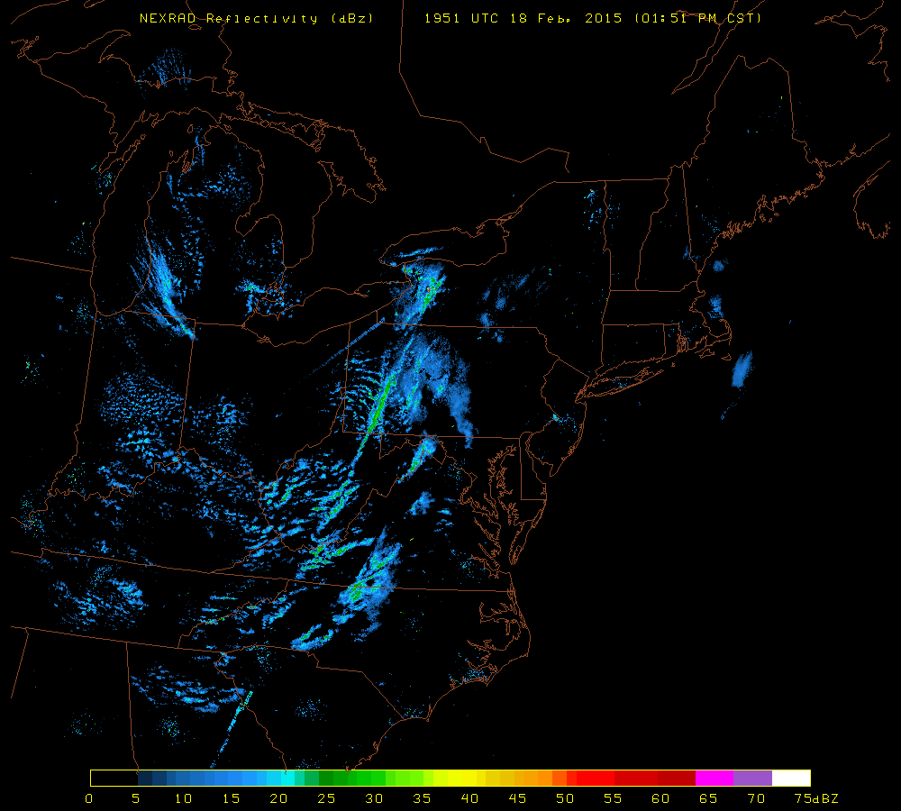
[Latest NEXRAD radar image showing snow bands setting up to the west of the I-95 corridor; map courtesy University of Wisconsin]

Discussion

Snow showers/snow squalls The coldest air mass of the season so far is plowing towards the eastern US and its arrival this evening will generate snow showers and snow squalls in the I-95 corridor. Just like the previous Arctic frontal passage this past weekend, heavy snow bursts can quickly have an impact on visibility and road conditions and a coating to an inch of snow accumulation can take place in a hurry. The arrival of the snow is likely around 5-7PM in DC, 7-9PM in Philly and 9-11PM in NYC, but the threat for snow showers will continue well into the night and there can actually be more snow showers on Thursday.

Record-breaking cold As far as temperatures are concerned, this air mass is likely to break many records in the eastern US between Thursday and Saturday with sub-zero low temperatures likely in much of the I-95 corridor; especially on Friday and Saturday mornings. In fact, in many parts of the I-95 corridor, this cold air outbreak could produce temperatures not seen around here since January 1994. All of this is courtesy of an air mass that crossed over the North Pole from Siberia and is about to pounce on the eastern US. Temperatures moderate noticeably late Saturday after a bitter cold start to the day and they could actually surpass 40 degrees in much of the I-95 corridor on Sunday before yet another Arctic blast occurs early next week.

850_mb_temp_anom_for_thurs 
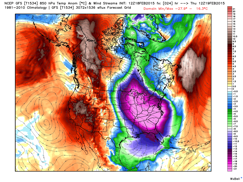
[Lower atmosphere (850 mb) temperature anomalies for Thursday; map courtesy Weather Bell Analytics]

7:00 AM | ***Another powerful Arctic frontal passage to spark snow showers late today/early tonight and possible heavier snow squalls...brutally cold air will follow for Thursday into Saturday...sub-zero temperatures possible with this next Arctic blast***

Paul Dorian

6-Day DC Forecast

Today

Becoming mostly cloudy, still quite cold, snow showers possible by late afternoon, perhaps even a heavier snow squall or two, highs near 30 degrees

Tonight

Evening snow showers, possibly a heavier snow squall or two, a coating to an inch of new snow accumulation is possible along with slick spots on roadways, turning breezy and brutally cold by morning with lows in the upper single digits

Thursday

Bitter cold with variable clouds, windy, still the chance for a few snow showers, highs only reaching the low-to-middle teens

Thursday Night

Downright fierce cold with possible sub-zero temperatures by morning (perhaps even record-breaking), partly cloudy skies, still windy with painfully low wind chills

Friday

After a possible sub-zero start continued bitter cold with partial sunshine, breezy, highs only reaching the upper teens

Saturday

Mostly cloudy, still quite cold, but not as harsh, chance for snow late in the day and then a mixed bag of precipitation at night, near freezing for highs

Sunday

Mostly cloudy, milder, good chance for plain rain, low-to-mid 40's

Monday

Partly sunny, colder again, near 30 degrees

Discussion

Another powerful Arctic front is approaching the I-95 corridor and it is likely to spark some snow shower activity from late today into tonight and there can be a heavier snow squall or two. In fact, it is not out of the question that there be a quick coating to an inch of new snow given the strong upper-level energy that is associated with this surface frontal system. Once this front passes through the region, incredible cold Arctic air will flood the region. The period from late tonight into early Saturday will be frigid indeed with amazing sub-zero low temperatures likely on Friday morning - perhaps even record-breaking. Saturday starts off very cold, but it’ll turn milder late in the day along with the chance for some snow. By Saturday night and Sunday, it should become mild enough for a mixed bag of precipitation to be followed by plain rain with high temperatures reaching 45 degrees late in the weekend before yet another very cold air mass arrives for the early part of next week.

7:00 AM | ***Winter's worst weather continues with more snow and incredible cold including possible sub-zero temperatures***

Paul Dorian

6-Day DC Forecast

Today

Becoming partly sunny, quite cold, highs in the mid-to-upper 20’s

Tonight

Mostly cloudy, very cold, lows in the middle teens

Wednesday

Mostly cloudy, still quite cold, snow showers possible in the afternoon and there can be a heavier snow squall, a quick coating to an inch possible, mid-to-upper 20’s

Wednesday Night

Snow shower threat continues early; otherwise, becoming partly cloudy and becoming brutally cold, lows by morning in the single digits

Thursday

Bitter cold with partial sunshine, maybe a snow shower, highs only reaching the middle teens

Friday

Possible sub-zero start to the day, bitter cold with partial sunshine, highs only reaching the mid-to-upper teens

Saturday

Mostly cloudy, not as harsh, chance for PM snow, low 30’s

Sunday

Mostly cloudy, milder, chance for rain, ice or snow, mid-to-upper 30’s

Discussion

This stretch with the worst weather that winter has to offer will continue over the next several days with more snow and incredible cold including possible sub-zero low temperatures. Now that the latest snowfall has ended in the I-95 corridor, attention turns to the next important weather event. Indeed, another powerful Arctic front will arrive late tomorrow and it is likely to generate late afternoon and early evening snow showers along with a possible heavier snow squall. In fact, this frontal passage could produce a quick coating to an inch of new snow later tomorrow and early tomorrow night and there can be slick spots on the roads as a result. Incredible cold pours in behind the front for Thursday, Friday and Saturday. Low temperatures will bottom out at extremely cold levels during that stretch with single digits likely on Thursday and Saturday morning's and sub-zero temperatures - possible record-breaking - likely on Friday morning. More snow is possible by late Saturday, but as the weekend progresses, the temperatures will climb to levels which will allow for the possibility of precipitation other than in the form of snow.

Video

httpv://youtu.be/qwsSY00SdTA

1:30 PM | ****Snow on the way****

Paul Dorian

Discussion

No significant changes from the morning timetable and snow accumulation estimates…snow has begun in the last hour in Charlottesville and Culpeper in Virginia - just to the southwest of DC - and it should arrive in the DC metro region between 3 and 6pm. The snow will hold off until after the evening commute in the Philly metro region not arriving until 6-10pm. In NYC, the snow will hold off until late tonight likely not arriving up there until the 12am-4am time period. Accumulations by mid-day Tuesday still look higher in the southern and eastern portions of the I-95 corridor region with 6-9 inches likely in the area from DC to the (southern) Jersey Shore, 4-7 inches in and around Philly (the higher amounts to the south and east, the lower amounts to the north and west), and 2-5 inches in the NYC metro region. Snow showers and snow squalls are possible late Wednesday as another brutally cold Arctic invasion arrives. Thursday and Friday will be downright frigid with possible record-breaking cold.

7:00 AM | *****Frigid cold this morning, significant accumulating snow from later today into tomorrow morning...more brutal cold follows later this week which could produce temperatures not seen here since Jan 1994*****

Paul Dorian

6-Day DC Forecast

Today

Thickening clouds, frigid, snow develops late in the afternoon, temperatures will struggle to reach the 20 degree mark

Tonight

Snow will be heavy at times, very cold, lows in the middle teens

Tuesday

Snow in the morning with total accumulations of 6-9 inches by mid-day, partial sunshine in the afternoon, very cold, upper 20’s

Tuesday Night

Mostly cloudy, very cold, mid-to-upper teens

Wednesday

Mostly cloudy, breezy, very cold, snow showers possible at times, possibly a snow squall, additional small accumulations possible, upper 20’s

Thursday

Brutal cold that will be record-challenging, partly sunny skies, upper teens for highs

Friday

Brutal cold that will be record-challenging, partly sunny skies, upper teens for highs

Saturday

Mostly cloudy, cold, chance for snow, low 30’s

Discussion

Winter will put on an amazing display this week and here is a quick summary: frigid cold this morning with temperatures in the single digits will be followed by significant snowfall from late today into early Tuesday; snow showers and snow squalls should take place late Wednesday with additional small accumulations possible, and that will be followed by record-challenging cold on Thursday and Friday.

Today starts off on the frigid side and temperatures this afternoon will struggle to reach the 20 degree mark. Snow will break out late today likely in the 3-6pm time period and continue heavily at times right into Tuesday morning. The total snowfall accumulation range in the DC metro region by mid-day Tuesday will likely be 6-9 inches, and the Eastern Shore should receive similar amounts. This snowfall will have serious implications on the Tuesday morning commute, school openings, etc. Another Arctic blast arrives late Wednesday likely accompanied by snow showers/snow squalls and additional small accumulations, and then record-challenging cold on Thursday and Friday which may even surpass this morning's fierce cold for its severity.

One final note, Dulles Airport (VA) dropped to 6 degrees this morning shattering the old record low of 11 degrees; BWI Airport (MD) bottomed out at 5 degrees tying a record set way back in 1905.

10:30 AM | ****Accelerated accumulating snow threat - now set for late Monday into Tuesday****

Paul Dorian

record_lows
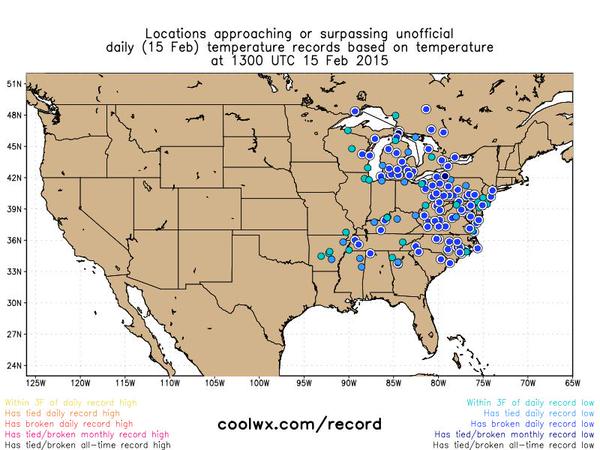
[Record or near record lows from early Sunday; courtesy "coolwx.com"]

Discussion

I should have known better. Tomorrow is President’s Day and this particular holiday has a way of attracting snowstorms (e.g., 1979, 2003). What was once looking like an accumulating snow threat for the time period of Tuesday into Wednesday is now looking like a serious threat for late Monday into Tuesday. In fact, anywhere from a few-to-several inches of snow is looking possible now from late Monday into Tuesday in the I-95 corridor region from DC-to-Philly-to-NYC with perhaps the threat for the heaviest snowfall in the DC metro region. This snow event could certainly have serious implications on the Tuesday morning commute, school openings, etc. Preliminary snowfall estimates by Tuesday mid-day are as follows: 6-10 inches in DC, 4-8 inches in Philly, 3-6 inches in NYC.

Today’s "slap-in-the-face" Arctic cold in the Mid-Atlantic region ensures that this next event will be an all-snow event. Low temperatures in the overnight hours will drop to 0 degrees or even slightly below in many I-95 corridor locations to start the new work week and the scary news is that the same extreme type of cold could happen again later in the week. Records will be challenged in many Mid-Atlantic locations on Monday morning as well as on Thursday and Friday mornings of this upcoming week. Another brutal cold Arctic outbreak - perhaps even colder than the current blast - will follow behind the next storm with the second half of the week featuring widespread, extreme and sustained bitter cold across the eastern US. Incredible stuff.

temps_for_next_5_days 
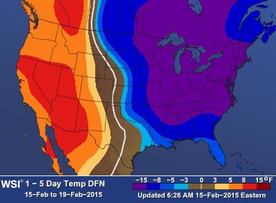
[5-day temperature pattern from today through Thursday...brutal cold in the eastern half of the nation; courtesy WSI]

8:30 AM | ****Incredible looking overall long-term pattern: afternoon/night accumulating snow with heavy squalls, damaging winds late tonight/early Sunday with possible power outages, painful cold on Sunday, multiple additional snow threats and brutal cold air outbreaks****

Paul Dorian

radar
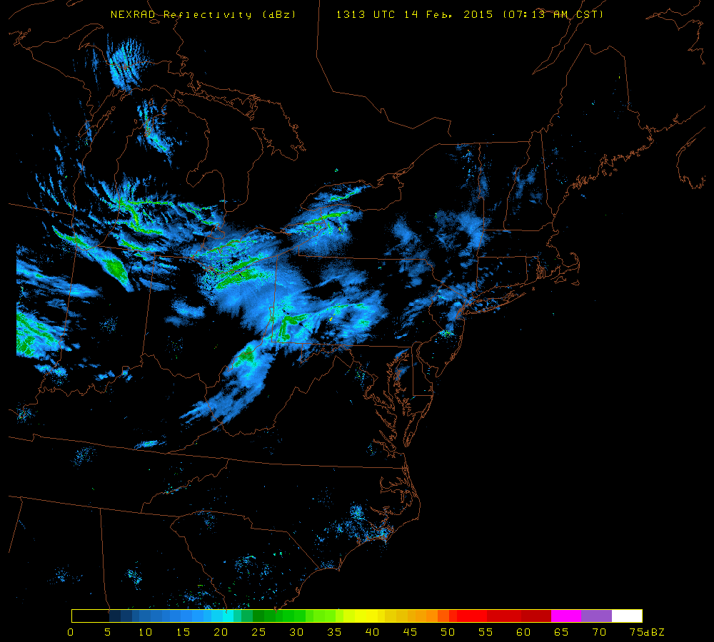
[Early morning NEXRAD radar image with snow over the Great Lakes/Ohio Valley and headed our way; image courtesy University of Wisconsin]

Discussion

The next 24-36 hours will bring us accumulating snow with heavy squalls, high impact winds, painful cold and dangerous sub-zero wind chills as a result of tremendous intensification of a storm system off the Northeast US coastline. This storm is currently located over southeastern Ontario and it will drop rapidly today towards the I-95 corridor region. Once this system reaches the coastal waters it will deepen explosively by some 36 millibars in a 24-hour period. The combination of the relatively warm waters of the western Atlantic Ocean, an extremely vigorous upper-level wave of energy, and a powerful upper-level jet streak will help cause this rapid intensification during the next 24 hours or so. This type of rapid and significant intensification will lead to a very sharp pressure gradient across the Northeast US which, in turn, will lead to extreme wind gusts on the order of 55 mph or so in the period between late tonight and Sunday morning (approximately 3 am to noon). Unfortunately, power outages are quite possible with this type of wind from late tonight into early which is the same time the coldest air of the season comes pouring into the region. Winds will slowly decrease later Sunday afternoon and evening.

As far as the snow is concerned, while there can be some snow seen this morning, the majority of the snow showers and possible heavier snow squalls should occur this afternoon and continue this evening. The snow part of this event will really consist of two parts: one part associated with the Arctic front from this afternoon into the late evening hours and then the second part associated with the developing storm late tonight and early Sunday. Some of the snow squalls this afternoon and evening can be quite intense with brief heavy snowfall, gusty winds, very poor visibility ("white out" conditions) and quick accumulations. Late tonight and early tomorrow will pose another chance for additional snowfall from eastern PA northeast across New Jersey and New York City as the storm deepens rapidly off the coastline. In fact, New York City could end up with its heaviest snowfall during this latter portion of the storm when an “inverted trough” extends to the northwest of the intensifying surface low pressure center. One final note on the snow, it is possible that some "thunder snow" occurs during the next 24 hour in portions of the I-95 corridor given this tremendous upper-level suport and upward motion in the atmosphere.

Accumulations by tomorrow morning are likely to be in the 1-3 inch range across Philly, a coating to 2 inches in the DC metro region, and 2-5 inches in and around NYC metro region. However, we'll have to watch for a potential surprise late tonight and early Sunday for additional snowfall in the Philly metro region and especially in the New York City metro region which could add to these preliminary accumulation estimates. Much of the snow that does accumulate will be whipped around by powerful winds late tonight and on Sunday with considerable blowing and drifting possible in some areas. Temperatures are likely to drop to single digits by early tomorrow throughout the I-95 corridor, then struggle to rise at all during the day, and then plunge to possible record-breaking territory by early Monday morning in the area of 0 degrees or even slightly below.

Another system could throw significant accumulating snow our way late Tuesday into early Wednesday, but that storm track is still somewhat uncertain. However, what is quite certain is that there will be more bitter cold air for the second half of next week and beyond and there will be multiple additional snow threats as an unbelievable long-term pattern is shaping up for the Mid-Atlantic region.