Contact Us

Use the form on the right to contact us.

You can edit the text in this area, and change where the contact form on the right submits to, by entering edit mode using the modes on the bottom right. 


123 Street Avenue, City Town, 99999

(123) 555-6789

email@address.com


You can set your address, phone number, email and site description in the settings tab.
Link to read me page with more information.

backlit-stratus-clouds-2013-04-05.jpg

Blog

Weather forecasting and analysis, space and historic events, climate information

Filtering by Category: DC

12:00 PM | **Looks like a real mess on Sunday with a buildup of snow and/or ice depending on location; another complex and interesting precipitation event comes in the Tuesday-Thursday time frame**

Paul Dorian

usfntsfcwbg
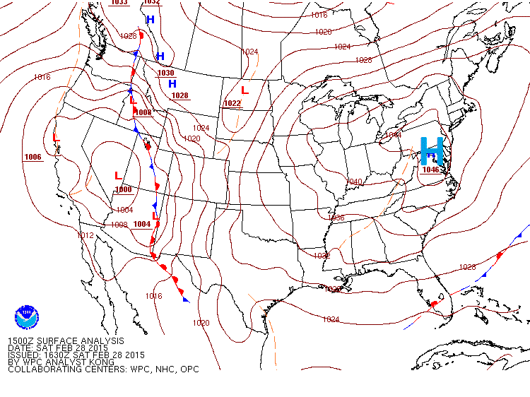
[Mid-day US surface weather map with very strong Arctic high pressure centered right over the Mid-Atlantic; courtesy NOAA]

Discussion

Overview The weekend begins with very strong Arctic high pressure sitting right on top of the Mid-Atlantic region (surface map above) assuring us plenty of sunshine today along with light winds. Atmospheric pressure readings at mid-day are as high as 30.85 inches (1045 millibars) in parts of the Mid-Atlantic region associated with this very dense and cold Arctic air mass. The combination of this entrenched dense, cold dome of Arctic air and moisture streaming in from the west on Sunday spells big trouble for the DC, Philly and NYC metro regions with accumulating snow or a significant buildup of ice or both real threats as we close out the weekend.

Details As the high pressure shifts off the east coast on Sunday, a warm advection pattern will set up with light snow likely to break out in the pre-dawn hours across western and central portions of the Mid-Atlantic region. During the mid-morning to late-morning hours, snow is likely to break out in the I-95 corridor and it will likely change to a wintry mix in the DC metro region after a few hours, but not before there is a coating to an inch or two of new snow accumulations. The snow will continue for a longer time period across SE PA with 2-4 inches likely before any changeover and areas to the north of I-80 are probably the luckiest of all as the snow up there could hang on for most or all of this upcoming precipitation event; thereby reducing chances up there for any serious ice buildup. The New York City metro region should receive several hours of snowfall before any changeover takes place with 3-5 inches of accumulation possible in that area. The period of icing following the initial “thumping” of snow can produce a significant buildup of ice later Sunday into Sunday night; especially, in the region from the N and W suburbs of DC to the N and W suburbs of Philly. All precipitation winds down in the pre-dawn hours early Monday and the rest of the day remains cold and becomes quite breezy.

“Banding” possibility could enhance snow (or ice) totals in parts of the area One final word of caution on tomorrow’s event…there will be impressive upward motion at mid-levels of the atmosphere centered around northeastern Maryland and southeastern Pennsylvania late in the day. The 12Z NAM forecast map (below) for early tomorrow evening shows this area of mid-level upward motion (850 millbar absolute vorticity) centered near the eastern part of the Mason-Dixon Line. Often times with this kind of concentrated upward motion, there can be “banding” that sets up in the precipitation field and this could lead to enhanced snowfall (or ice) amounts in a short period of time over parts of the area…something to watch for later tomorrow.

nam_namer_036_850_vort_ht 
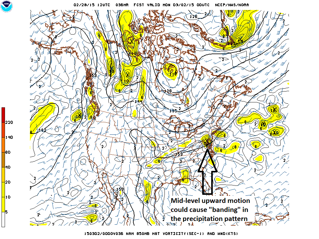
[12Z NAM forecast map of 850 millibar absolute vorticity early Sunday night; courtesy NOAA]

Another interesting and complicated threat at mid-week Another complicated weather pattern is setting up for the I-95 corridor for the time period from later Tuesday into Thursday. Precipitation ahead of yet another strong Arctic cold frontal system is likely to arrive Tuesday afternoon and it could start as a wintry mix in the I-95 corridor. However, as milder air pumps in from the south ahead of the front, the precipitation is very likely to change to plain rain for Tuesday night into early Wednesday and some of the rainfall can be on the heavy side. Temperatures could actually climb into the 50’s in portions of the I-95 corridor during the day Wednesday before colder air returns to the region. The Arctic cold frontal system may then stall out as it reaches the east coast on Wednesday night and there is a chance that low pressure develops along the frontal boundary zone and rides up along it right into the I-95 corridor - and into the incoming colder air. If indeed this takes place, it could very well turn cold enough for significant accumulating snow around here sometime in the late Wednesday night/Thursday time frame. Stay tuned.

1:15 PM | **Another weekend and another accumulating snow and ice threat for the Mid-Atlantic**

Paul Dorian

GFS_snow_forecast
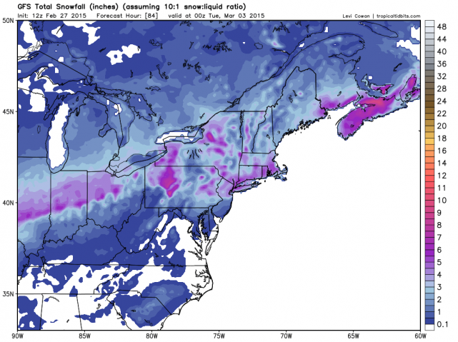
[Total snowfall forecast by the 12Z GFS for the upcoming event; map courtesy "tropicaltidbits.com", NOAA]

Discussion

Weekends have featured very active weather in recent weeks in the I-95 corridor and it looks like this weekend will be no exception. In fact, it appears that there could be a quick “thumping” of accumulating snow later Sunday; especially, in the region between Philly and New York City, and this accumulating snow will be followed by a period of icing. Sound familiar, in many ways this pattern resembles last weekend's situation in which bitter cold weather on Saturday was followed by accumulating snow and then a period of ice on Sunday. In fact, in another similar twist, much of last weekend’s frozen precipitation event took place with an unusual southerly wind direction as high pressure moved off the east coast – usually a recipe for rain around here - and a similar pattern is likely late this weekend. There does appear to be one difference from this upcoming event compared to last weekend and that is the idea that it appears the “thumping” of accumulating snow may take place farther north than last weekend - this time from Philly-to-NYC instead of from DC-to-Philly.

Currently, it looks like precipitation should arrive in the I-95 corridor in the form of snow during the afternoon hours on Sunday with accumulations likely at the onset. The snow will likely change rather quickly to a wintry mix in the DC metro region, but it could hold on as snow for a longer time in the region between Philly and NYC where a few inches can accumulate before a changeover finally takes place and there is a buildup of ice. Much like last weekend, a layer of crusty ice is likely to form on any snow that does accumulate in the I-95 corridor and precipitation should end by early Monday. Temperatures will start off the weekend at very cold levels in the single digits in some suburban locations, but should turn (temporarily) warmer next week before yet another impressive blast of Arctic air arrives on Thursday.

7:00 AM | Quite cold as we end the work week and possible record cold as we begin the weekend...wintry mix likely later Sunday into Monday

Paul Dorian

6-Day DC Forecast

Today

Scattered early morning snow showers; otherwise, partly sunny skies, quite cold, highs not far from 30 degrees

Tonight

Mainly clear and very cold, lows not far from 10 degrees

Saturday

Mainly sunny, still quite cold, upper 20’s

Saturday Night

Partly cloudy, very cold, lows in the middle teens

Sunday

Becoming mostly cloudy, cold, chance for a wintry mix of precipitation late in the day and at night, mid 30’s

Monday

Becoming partly sunny, not as cold, low-to-mid 40’s

Tuesday

Mostly cloudy, colder, chance for a wintry mix that becomes plain rain, upper 30’s

Wednesday

Mostly cloudy, much milder, rain likely, upper 50’s

Discussion

Cold weather will close out the work week and the weekend will remain well-below normal for this time of year. In fact, record cold is possible early Saturday as temperatures overnight will plunge towards the 10 degree mark in most areas which can break some local records. February ends on Saturday and it will end up being one of the coldest February's ever in the area - Dulles Airport has had an amazing 9 mornings this month with single digit low temperature readings. As March begins on Sunday, a cold front will approach the Mid-Atlantic region. This front will likely generate a wintry mix in the region from later Sunday into early Monday. The 50's are likely for highs by the middle of next week, but it'll be accompanied by rainfall, perhaps heavy at times, and then another batch of Arctic air should return on Thursday.

Video

httpv://youtu.be/NB-azcWSvzc

6:00 AM | **Another poorly timed snow event as 1-3 inches of snow impacts the morning commute**

Paul Dorian

6-Day DC Forecast

Today

Cloudy with snow during the morning hours, 1-3 inches of accumulation by mid-day with the lower amounts in that range to the N and W and the higher amounts to the S and E, cold, highs in the upper 20’s

Tonight

Cloudy, quite cold, maybe a snow shower or two, lows in the upper teens

Friday

Mostly cloudy, quite cold, maybe a snow shower or two, blustery, upper 20’s

Friday Night

Partly cloudy, very cold, lower teens for low temperatures

Saturday

Mostly sunny, still quite cold, near 30 degrees

Sunday

Becoming mostly cloudy, cold, chance for snow or a wintry mix at night, upper 30’s

Monday

Mostly cloudy, not as cold, chance for rain or snow, mid 40’s

Tuesday

Mostly cloudy, colder, chance for snow or rain, mid-to-upper 30’s

Discussion

Snow continues to fall across the DC metro region this morning, but it should wind down by the late morning or mid-day hours. Accumulations of 1-3 inches are likely by the time the snow ends with the lower amounts in that range to the north and west of the District and the higher amounts inside the District and points south and east. Our Arctic cold will be renewed following the passage of this southern system with well-below normal temperatures continuing right through the upcoming weekend.

12:35 PM | **1-3 inches of snow just in time to impact the morning commute**

Paul Dorian

Discussion

An area of moisture across the Deep South will come close enough to the DC metro region to generate 1-3 inches during the late night and early morning hours. Substantially more snow will occur from this southern storm well to the southeast of the District with 6 inches of accumulation possible in Richmond, VA and nearly a foot in Norfolk, VA. Snow should break out in the DC metro region during the wee hours of the morning (1-4am) and continue until late morning – perfect timing to mess up the morning commute. The lower snowfall totals in this 1-3 range will occur in the northern and western suburbs and the higher amounts should occur inside the District and on its southern and eastern sides. Any slight shift in the storm track could still have a big impact on the forecasted snowfall estimates so stay tuned.

7:00 AM | Looks like a southern system skirts the DC metro region with snow late tonight/early Thursday

Paul Dorian

6-Day DC Forecast

Today

Mainly sunny, breezy, not as harsh, highs in the mid-to-upper 30’s

Tonight

Becoming cloudy with snow breaking out after midnight, quite cold, lows in the lower 20's

Thursday

Cloudy with snow during the morning hours, cold, a coating to an inch or two of snow likely in the District and immediate N and W suburbs, 2-3 inches of new snow likely just to the south and east of DC, upper 20’s

Thursday Night

Maybe a lingering snow shower early; otherwise, partly cloudy, very cold, upper teens

Friday

Partly sunny, still quite cold, maybe a snow shower, upper 20’s

Saturday

Partly sunny, cold, low 30’s

Sunday

Becoming mostly cloudy, cold, chance for snow or a wintry mix at night, upper 30's

Monday

Mostly cloudy, not as cold, chance for rain or snow, mid-to-upper 40’s

Discussion

Temperatures will moderate today ahead of another Arctic frontal system, but then we’ll return to the deep freeze for the latter part of the week following the frontal passage. Meanwhile, an area of moisture in the Deep South will head northeast today and will skirt the DC metro region late tonight and early Thursday. Snow should break out across the region late tonight and continue into early Thursday with a coating to an inch or two of new snow likely in the District and immediate northern and western suburbs. Two to three inches of new snow are possible just to the south and east of DC with three or four inches possible across the southern part of the Delmarva Peninsula.

Video

httpv://youtu.be/p0_ikWuPbCo

7:00 AM | After a very cold Tuesday, temperatures will moderate on Wednesday, but Arctic air replenishes for the second half of the week; an area of moisture skirts the region early Thursday with light snow likely

Paul Dorian

6-Day DC Forecast

Today

Mainly sunny, still quite cold, light winds, highs in the mid 20’s

Tonight

Mostly cloudy, quite cold, lows not far from 20 degrees

Wednesday

Partly sunny, not as harsh, upper 30’s

Wednesday Night

Becoming cloudy, quite cold, light snow likely late, upper teens for lows

Thursday

Clouds early with light snow likely early then becoming partly sunny, quite cold, upper 20’s for highs

Friday

Partly sunny, still quite cold, upper 20’s

Saturday

Partly sunny, not as harsh, mid 30’s

Sunday

Partly sunny, cold, chance for rain or snow late, near 40 degrees

Discussion

The beat goes on as far as the extreme cold is concerned in the eastern US. Temperatures this morning reached record low levels in many areas and, to make matters worse, there is accumulating snow falling as far south as Georgia. A small sampling of today's impressive record low temperatures include the following:

1) Pittsburgh, PA breaks a record held since 1914 (new record -9 degrees, old record -2 degrees) 2) Dulles Airport, VA absolutely annihilates the previous record by 18 degrees when it bottomed out at -4 degrees earlier today (old record of +14 degrees was set in 1967) 3) Buffalo, NY breaks a record held since 1889 by dropping to -7 degrees 4) Chicopee, MA breaks a record by 14 degrees (new record is -19 degrees, old record was -5 degrees set in 1948) 5) Windsor Locks, CT sets record at -8 degrees (old record of -4 degrees was set in 1907) 6) JFK Airport in NYC dropped to a record low of 7 degrees breaking the old record of 14 degrees set in 1968

Finally, while not a record, the low temperature this morning in Punxsutawney, PA was -21 degrees and the groundhog was heard saying "I told you so".

Temperatures here today will struggle to reach the middle 20's, but at least the winds will be on the light side so wind chills will not be much of an issue. Noticeable modification will take place on Wednesday ahead of the next Arctic front, but we'll get right back into the deep freeze during the second half of the week. An area of moisture that continues to bear watching will scoot just to our southeast early Thursday, but it could come just close enough to throw some light snow into portions of the DC metro region and any slight shift in the storm track could have an important impact on our local forecast.

7:00 AM | Another week...another Arctic blast (or two)

Paul Dorian

6-Day DC Forecast

Today

Clouds this morning will give way to increasing amounts of sunshine, maybe an early snow shower, windy, quite cold with temperatures dropping through the 20's along with much lower wind chills

Tonight

Mostly clear, blustery, brutally cold with low temperatures in the single digits and sub-zero wind chills

Tuesday

Mostly sunny, still very cold, upper 20’s

Tuesday Night

Mostly cloudy, quite cold, near 20 degrees

Wednesday

Partly sunny, not as harsh, mid-to-upper 30’s

Thursday

Partly sunny, much colder again, windy, mid-to-upper 20’s

Friday

Partly sunny, quite cold, upper 20’s

Saturday

Partly sunny, not as harsh, low-to-mid 30’s

Discussion

After a temporary “warm-up” on Sunday following the weekend snowfall, more Arctic air is pouring into the Mid-Atlantic region today and the new work week will get off to a much colder start compared to the end of the weekend. Temperatures today will drop through the 20's and an increasing wind will generate much lower wind chill values. Temperatures tonight will once again flirt drop to the single digits in much of the I-95 corridor and, unfortunately, that may not be the last time this week as very cold conditions are likely again late in the week after the arrival of another Arctic blast.

Looking back to the significant weekend snowfall in the I-95 corridor, what was quite amazing is that it took place with a steady, strong southerly wind. In normal winters, this type of synoptic weather pattern would have produced little in the way of accumulating snow in the I-95 corridor; especially, in late February, but given the extreme cold heading into the weekend, even a southerly wind couldn’t stop several inches of snow accumulation in the DC-to-NYC corridor.

Video

httpv://youtu.be/Ii6R6gtVw4E

7:45 AM | *****Heavy snow on the way with significant accumulations before a changeover to a period of ice*****

Paul Dorian

radar[Latest NEXRAD radar image with moisture in western sections of the Mid-Atlantic; courtesy University of Wisconsin]

Discussion

Skies remained clear for much of the night in the Mid-Atlantic region which allowed temperatures to fall to record levels in some areas. In fact, temperatures plunged to an amazing 6 degrees below zero this morning in Atlantic City, NJ breaking the record there and making this the latest date ever with sub-zero conditions. Records were also set this morning in Allentown, PA, Wilmington, DE and Trenton, NJ.

Meanwhile, those early morning partly cloudy can be deceiving…a mountain of moisture (see radar) is moving quickly from southwest-to-northeast right towards the I-95 corridor and - given these extremely cold temperatures - that spells trouble. Snow will arrive in the DC metro region during the mid-to-late morning hours, in Philly during the mid-day hours, and in NYC during the late afternoon hours. The snow will fall heavily shortly after its arrival with quick accumulations and rapid deterioration in road conditions. The snow will ultimately change to a period of icing (sleet, freezing rain) after significant accumulations and this will add a layer of ice on top of the snow. Towards the latter stages of this storm, areas in the immediate I-95 corridor and points to the south and east of there may actually change to plain rain with above freezing temperatures, but the plain rain and “milder” weather will not be major factor in this upcoming event – frozen precipitation-type (i.e., snow, sleet, freezing rain) will dominate with a thumping of accumulating snow at the onset. In some of the farther N and W suburbs, temperatures will probably not even make it above the freezing mark throughout this precipitation event. Precipitation winds down early Sunday and another brutally cold Arctic blast will arrive on Monday - we'll be flirting with 0 degrees once again by the time Tuesday morning rolls around.

Snow accumulations will generally be higher the farther north and west one goes away from the big cities along I-95. As a result, here are the latest snowfall estimates which will take place before the changeover:

DC: 4-8 in an around the immediate District region; 6-10 inches in the northern and western suburbs

Philly: 3-6 inches in and around the immediate Philly metro region; 4-8 inches in the northern and western suburbs

NYC: 3-6 inches in and around the immediate NYC metro region; 4-8 inches in the northern and western suburbs

2:30 PM | ****More on today' extreme cold and tomorrow's accumulating snow and ice threat****

Paul Dorian

records_for_feb_20_2015

Discussion

More on today’s extreme cold A bit more on this morning’s extreme cold in the eastern US... dozens and dozens of records were set this morning throughout the eastern US and some are summarized in the table above provided by NOAA. Philadelphia International Airport bottomed out at 2 degrees above zero which did not break a record as it missed a tie by just one degree; however, it was the coldest reading in Philadelphia since January 20, 1994 – i.e., the coldest in Philly in 21 years. Reagan National Airport in Washington, DC broke a record held there since 1896 by reaching 5 degrees this morning. This was the first time since 1996 in Washington, DC that the temperature fell to as low as 5 degrees (above zero).. Lynchburg, Virginia absolutely smashed their daily record this morning by plunging to -11 degrees with the previous record of +7 degrees being set in 1896. In fact, this turned out to be the all-time lowest temperature ever recorded in Lynchburg, Virginia. Additionally, Flint, Michigan attained their all-time low temperature this morning by plunging to -25 degrees. Earlier in the week, Cape Girardeau, Missouri (-19 degrees), Erie, Pennsylvania (-18 degrees), and Jamestown, New York (-31 degrees) set their all-time low temperature records.

Accumulating snow and ice threat on Saturday A large area of moisture is headed our way this weekend and it will arrive during the day on Saturday in the form of snow with accumulations very likely followed by an extended period of icing (sleet, freezing rain) in many areas. Eventually, advancing warmer air will likely cause a changeover of the snow to sleet and freezing rain and then ultimately to plain rain - at least in the immediate I-95 corridor and points south and east. However, before the snow changes to sleet and freezing rain, it is likely that snow accumulations reach 2-5 inches in the region from DC-to-Philly-to-NYC with the higher amounts in that range to the north and west and the lesser amounts to the south and east. There will be an extended period of icing following the accumulating snow and before any eventual change to plain rain. Snow should develop in the DC metro region during the late morning-to-mid-day hours, in Philly during the mid-day-to-early afternoon hours, and in the NYC region by late afternoon. The period of icing is in DC is likely during the late afternoon/early evening hours, in Philly during the early-to-mid part of tomorrow night and then late at night in the NYC region. Before the snow mixes with and then changes over to sleet and freezing rain, it will come down quite heavily at times. Given the extremely cold ground conditions and potential heavy snowfall before the changeover, snow accumulations will likely be quite rapid.