Contact Us

Use the form on the right to contact us.

You can edit the text in this area, and change where the contact form on the right submits to, by entering edit mode using the modes on the bottom right. 


123 Street Avenue, City Town, 99999

(123) 555-6789

email@address.com


You can set your address, phone number, email and site description in the settings tab.
Link to read me page with more information.

backlit-stratus-clouds-2013-04-05.jpg

Blog

Weather forecasting and analysis, space and historic events, climate information

Filtering by Category: DC

1:00 PM | ***Spring officially begins on Friday and old man winter is saying “not so fast”… accumulating snow in the I-95 corridor***

Paul Dorian

gfs_snowfall
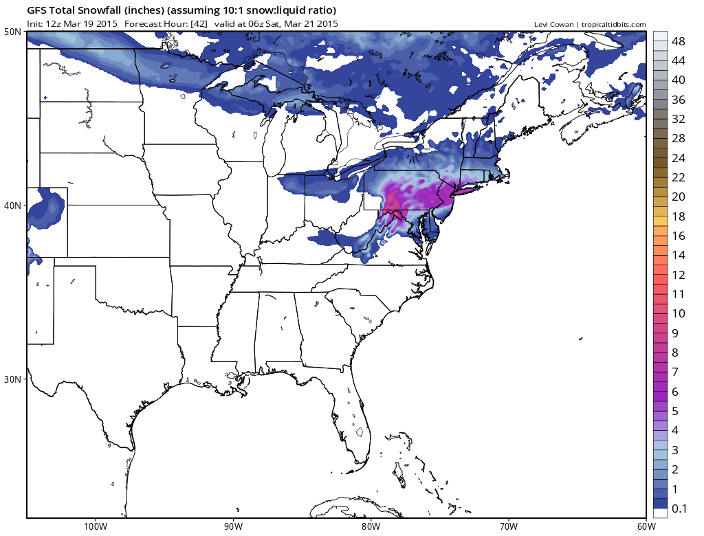
[12Z GFS snowfall forecast for tomorrow's event; map courtesy "tropicaltidbits.com", NOAA]

Discussion

Astronomical spring begins late tomorrow and old man winter is saying “not so fast”. In our transition back to a winter-like pattern, cold air made a return to the region late Tuesday night and Wednesday and now it appears very likely that accumulating wet snow will make a return on the same day that winter officially comes to an end. Accumulations are likely in all areas along the I-95 corridor and given the time of year and the fact that much of this snowfall will occur during daytime hours, they are quite likely to be highly dependent on elevation and surface type. As a result, expect wide ranges of accumulations across metro regions compared-to-normal on Friday with the highest amounts on grassy surfaces in elevated locations to the north and west of the big cities.

Low pressure will organize early Friday over the Carolinas and then gradually intensify as it moves to the northeast. Precipitation will overspread the I-95 corridor late tonight or early Friday - depending on location - and it should begin as accumulating snow in most areas. In the DC metro region, the snow will mix with and then change over to plain rain later in the morning, but it should hold on as primarily snow in the N and W suburbs of Philly and NYC during much of this upcoming event. The precipitation doesn’t wind down until later tomorrow evening in most areas. Slippery conditions can be expected on the roadways on Friday as the snow will come heavily at times during this event. On a positive note, the storm on Friday could be very photogenic. The wet nature of the snow could cling to tree limbs and surround early spring flowers that have begun to bloom.

gfs_early_afternoon 
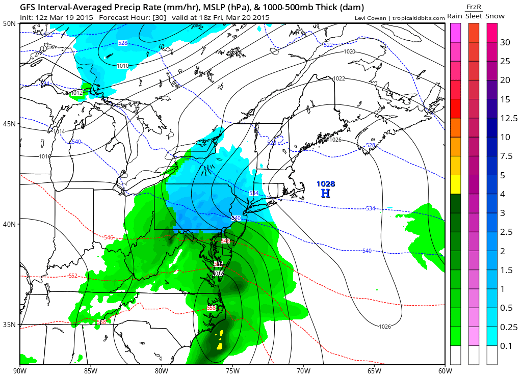
[12Z GFS forecast map for early tomorrow afternoon (blue=snow, green=rain); map courtesy "tropicaltidbits.com", NOAA]

Here are the details for each metro region in the Mid-Atlantic I-95 corridor:

DC region: Snow or rain that will quickly change to snow will develop after midnight and continue into early Friday morning. The snow should then mix with and change to plain rain later in the morning, but not before there are accumulations on the order of a coating to 2 inches in the District and nearby places to its south and east, 2-4 inches in the far N and W suburbs. The highest accumulation amounts should take place on grassy surfaces in elevated locations well to the west and north of the District. The Eastern Shore and Delmarva Peninsula regions should receive an inch or less of snowfall on Friday.

Philly region: Snow should break out right around daybreak and then continue through much of the day. There is a chance that the snow mixes with rain and/or sleet later in the day; especially, in Philly and nearby points to the south and east, but it could remain as all snow well to the north and west of the city. Accumulations expected are on the order of 2-4 inches in and around the immediate Philly metro area, 3-6 inches in the N and W suburbs. The highest accumulation amounts should take place on grassy surfaces in elevated locations well to the north and west of Philly. Southern New Jersey should receive a coating to two inches, central and northern New Jersey should end up in the 3-6 inch range.

NYC region: Snow should begin early Friday and continue through much of the day. There is a chance that the snow mixes with rain and/or sleet later in the day in the NYC metro region and nearby points to the south and east, but it is likely to remain as all snow to the north and west. Accumulations on the order of 3-6 inches are likely with the highest amounts in that range on grassy surfaces in elevated locations to the west and north of NYC.

1:00 PM | **Snow on Friday with an increase in snowfall estimates**

Paul Dorian

GFS_early_afternoon_Fri
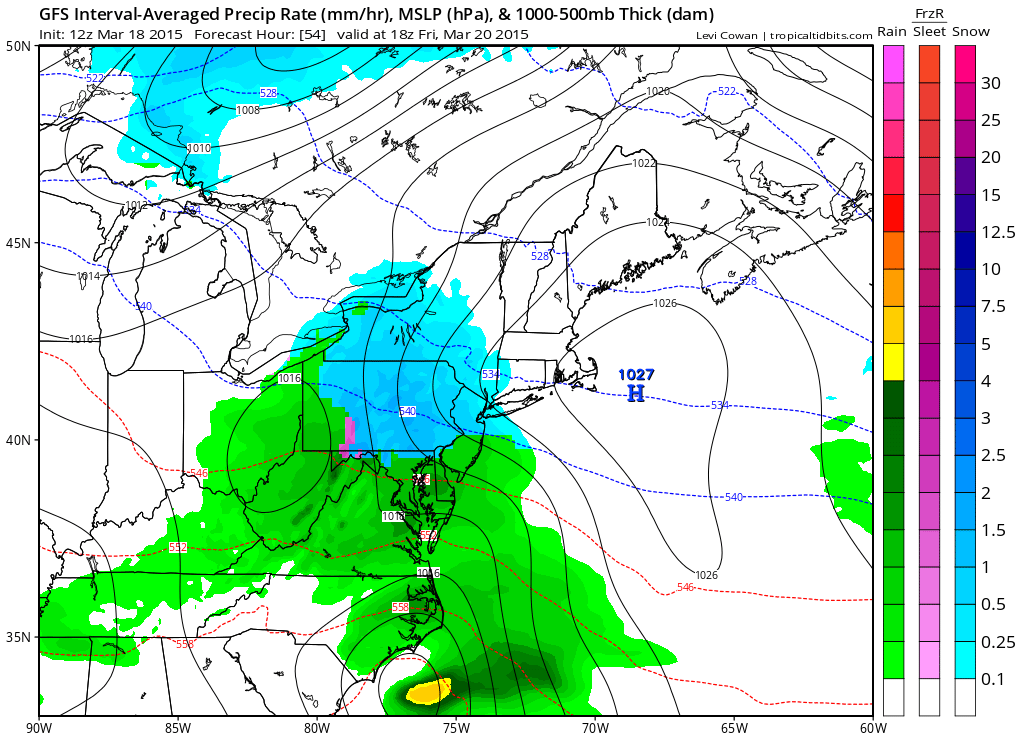
[12Z GFS forecast map for early Friday afternoon (blue=snow, green=rain); map courtesy "tropicaltidbits.com", NOAA]

Discussion

Our return to a winter-like weather pattern has begun with the latest influx of cold air and now attention turns to a very good chance of accumulating wet snow on Friday in the I-95 corridor. With cold air in place, low pressure will organize along the Mid-Atlantic coastline early Friday and then gradually intensify as it moves to the northeast. “Elevation” typically plays a critical role in late season snowfall amounts and this could lead to a wider range compared to normal on Friday across metro regions with respect to overall accumulations. The highest accumulations will likely take place on grassy surfaces in elevated locations to the north and west of the big cities and there certainly can be slippery conditions on the roadways.

Here is the breakdown for the I-95 corridor:

DC: Snow is likely to break out after midnight and continue into early Friday morning. The snow is then likely to mix with and change to plain rain later in the morning, but not before there are accumulations on the order of a coating to 3 inches with the higher amounts in that range on grassy surfaces in elevated locations to the west and north of the District.

Philly: Snow is likely to break out right around daybreak on Friday and continue through much of the day. The snow can mix with rain later in the day; especially, in Philly and nearby points to the south and east, but it could remain as all snow well to the north and west of Philly. Accumulations on the order of 2-5 inches are possible with the higher amounts in that range on grassy surfaces in elevated locations to the north and west of Philly.

NYC: Snow is likely to break out early Friday and continue through much of the day. The snow can mix with rain later in the day in NYC and nearby points to the south and east, but it is likely to remain as all snow to the north and west of the NYC metro region. Accumulations on the order of 2-5 inches are possible with the higher amounts in that range on grassy surfaces in elevated locations to the west of the NYC metro region.

One final note, it’ll turn milder on Saturday causing some snow melt, but then another cold air mass will arrive early next week and there may actually be another snow threat in the I-95 corridor by the middle of next week.

gfs_snow 
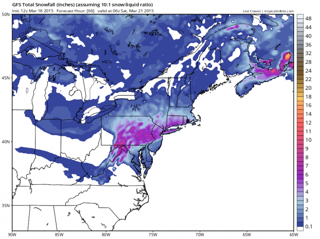
[12Z GFS snowfall amounts for the upcoming storm; map courtesy "tropicaltidbits.com", NOAA]

7:00 AM | **Cold air has arrived...snow threat continues for Friday...initial snowfall estimates**

Paul Dorian

6-Day DC Forecast

Today

Sunny, windy and cold for this time of year, highs in the mid-to-upper 40's

Tonight

Mainly clear, quite cold, winds die down, lows in the upper 20's

Thursday

Sunshine followed by increasing clouds, cold, mid-to-upper 40’s

Thursday Night

Becoming cloudy, cold, snow or snow and rain likely before daybreak, low 30’s

Friday

Cloudy, cold, snow likely early and rain likely late, a coating to an inch or two possible before the changeover to rain with the higher amounts on grassy surfaces and higher elevation locations to the north and west, upper 30's

Saturday

Partly sunny, milder, upper 50's

Sunday

Partly sunny, colder, mid 40’s

Monday

Partly sunny, cold, mid 40’s

Discussion

A strong cold front passed through the region yesterday and it has ushered in a major change to the overall weather pattern back to colder-than-normal conditions for the Mid-Atlantic region. This change will not be a short-lived and general colder-than-normal weather is likely through the remainder of March and into the first part of April. Temperatures today will struggle to climb through the 40's after soaring through the 60's on Tuesday.

In addition to the renewed cold, there may be multiple snow threats for the I-95 corridor over the next few weeks including one this Friday as low pressure organizes near the Mid-Atlantic coastline with fresh cold air in place. Snow is likely to break out before daybreak on Friday and it should then mix with and change to plain rain later in the day. Initial snowfall estimates are for a coating to an inch or two in the metro region before the changeover to rain with the higher amounts on grassy surfaces in higher elevation locations to the north and west. After a milder day on Saturday, another shot of cold air is destined to arrive here by early next week.

7:00 AM | **Colder pattern resumes late today/tonight...snow threat continues for late Thursday night/Friday**

Paul Dorian

6-Day DC Forecast

Today

Partly sunny, becoming quite windy, still quite mild with highs in the mid-to-upper 60’s around mid-day, but temperatures will drop late in the day

Tonight

Becoming mainly clear, still windy, turning noticeably colder, lows by morning in the upper 20's

Wednesday

Mainly sunny, windy, cold, highs struggle to reach 45 degrees

Wednesday Night

Partly cloudy, cold, near 30 degrees

Thursday

Increasing clouds, cold, chance for snow and/or rain at night, low-to-mid 40’s

Friday

Cloudy, cold, chance for snow and/or rain, low-to-mid 40’s

Saturday

Partly sunny, milder, upper 50’s

Sunday

Partly sunny, colder, upper 40's

Discussion

A strong cold front will arrive today and this will begin a major change back to a colder-than-normal weather pattern that should last right through the first part of April. While this does not mean that each and every day through this period will be colder-than-normal, the vast majority of the time will be below normal and there may be multiple threats for snow in the I-95 corridor. In fact, the first threat for snow in the I-95 corridor during this resumption of a winter-like pattern will take place late Thursday night and Friday as low pressure organizes near the Mid-Atlantic coastline with cold air in place. After a milder day on Saturday, another shot of cold air is destined to arrive early next week and there could even be another snow threat later next week for portions of the I-95 corridor. Buckle up, it's going to be a wild ride during winter's last gasp from tonight into the first part of April.

Video

httpv://youtu.be/IvlIbJJRKFw

12:30 PM | *Snow threat for late in the week as winter-like pattern resumes following our "spring break"*

Paul Dorian

Fri_night_GFS
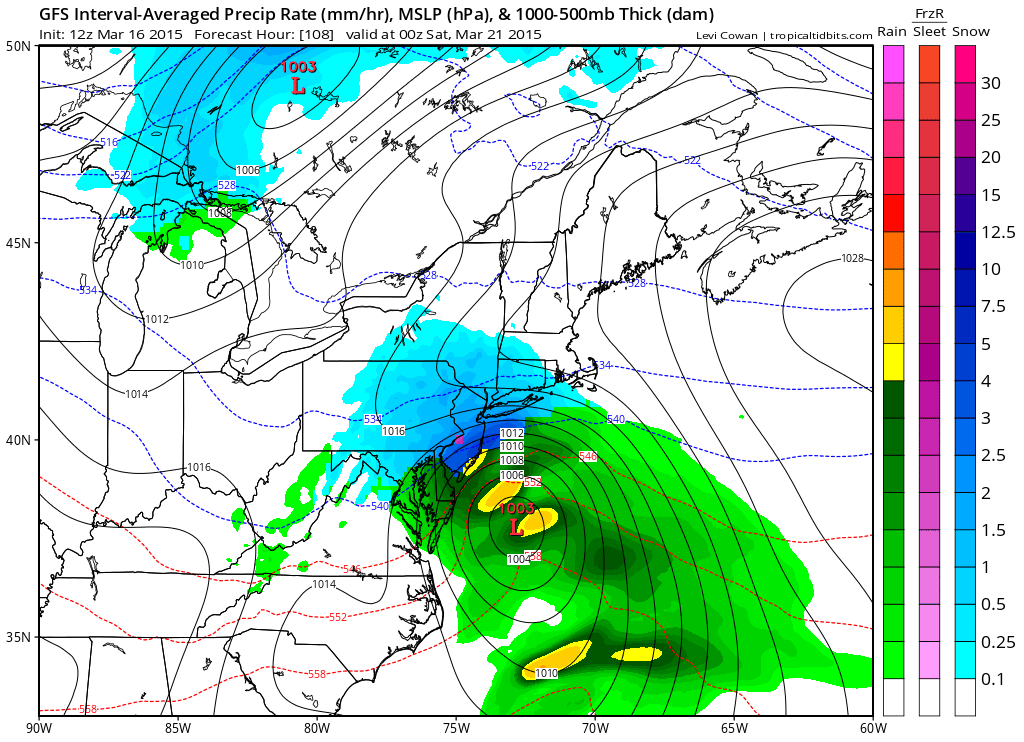
[12Z GFS model forecast map for Friday evening with snow (blue) in much of the I-95 corridor; map courtesy "tropicaltidbits.com", NOAA]

Discussion

Overview Our “spring break” period is about to end and a colder-than-normal weather pattern will resume on Wednesday, March 18th, and it looks like it will continue through the remainder of March and into the first part of April. In addition to the change back to the colder-than-normal temperatures, there is the threat for snow late this week as moisture in the southern states, and developing low pressure near the coast, collide with cold air in the I-95 corridor.

Details After a mild day to start the week, Tuesday will feature a strong cold frontal passage in the Mid-Atlantic region. While tomorrow can still be on the mild side, the winds will pick up noticeably and these winds will signal big changes in the offing for Wednesday (and beyond). In fact, temperatures are likely to drop into the 20’s later tomorrow night and struggle to pass 40 degrees on Wednesday in much of the Mid-Atlantic region. Moisture from the southern states will advance northward on Thursday and low pressure will begin to organize near the coast. By later Thursday night and Friday, with cold air in place in the I-95 corridor, it is indeed possible for snow to break out across DC, Philly and NYC as we head into the last day of the work week. The latest (12Z) GFS model forecast map for Friday evening depicts a pretty widespread area of snow (blue) throughout much of the I-95 corridor with low pressure off the coastline. Stay tuned.

7:00 AM | Quite a mild start to the week, but it gets colder again for the second half and beyond; there is even an outside chance for snow late in the week

Paul Dorian

6-Day DC Forecast

Today

Mostly cloudy, quite mild, highs in the mid 60’s

Tonight

Cloudy, cool, maybe a shower, lows near 45 degrees

Tuesday

Partly sunny, mild, quite breezy, maybe a couple of showers, near 65 degrees

Tuesday Night

Partly cloudy, breezy, turning colder, near 30 degrees

Wednesday

Mostly sunny, windy, noticeably colder, low-to-mid 40’s

Thursday

Mostly cloudy, cold, chance for rain or snow late in the day or at night, upper 40’s

Friday

Mostly cloudy, cold, chance for rain, upper 40’s

Saturday

Partly sunny, cold, low 50’s

Discussion

The new week will get off to a mild start today and Tuesday, but there will be plenty of clouds around and big changes will take place at mid-week. A strong cold front will arrive on Tuesday and it will usher in an important change to the overall weather pattern with the return of colder-than-normal air to the Mid-Atlantic region for the second half of the week and beyond. In fact, snow is even a possibility late this week as moisture will creep up the coast at the same time cold air will be in place around here. One final note, Boston, MA broke its all-time snowfall record this weekend for a winter season with more than 108 inches now officially recorded.

Video

httpv://youtu.be/uJcLfddiBmM

7:00 AM | Soaking rain event from late today through a good part of Saturday

Paul Dorian

6-Day DC Forecast

Today

Increasing clouds, chilly, rain possible by the end of the afternoon, highs in the low 50’s

Tonight

Periods of rain, heavy at times, chilly, lows in the low 40’s

Saturday

Periods of rain, heavy at times early, much milder, low 60's

Saturday Night

Mostly cloudy, lingering showers likely, chilly, low 40's

Sunday

Partly sunny, quite breezy, chilly, chance for a shower or two, low 50's

Monday

A very nice day with mostly sunny skies, quite mild, low 60's

Tuesday

Partly sunny, breezy, mild, maybe a shower, mid 50’s

Wednesday

Mostly sunny, colder, upper 40’s

Discussion

After a dry and chilly day to end the work week, soaking rain will move into the region by this evening and continue through a good part of the day on Saturday. The rain will come down heavily at times; especially, in the overnight hours early on Saturday morning and the end result for total rainfall should be between 0.75 and 1.00 inch. Sunday will feature some sunshine, but it’ll be quite breezy and a shower cannot be ruled out. The new work week will start out quiet and mild, but colder air will push into the Mid-Atlantic region by mid-week.

7:00 AM | Dry today, but soaking rain arrives late Friday and continues into Saturday

Paul Dorian

6-Day DC Forecast

Today

Mostly sunny, quite breezy, noticeably colder than yesterday, highs in the low-to-mid 50’s

Tonight

Mostly clear and quite cold, lows by morning near 32 degrees

Friday

Increasing clouds, cold, rain possible late in the afternoon, low 50's

Friday Night

Periods of rain, heavy at times, chilly, low 40’s

Saturday

Periods of rain, heavy at times, milder, near 60 degrees

Sunday

Partly sunny, breezy, chilly, chance for a couple of showers, low 50’s

Monday

Mostly sunny, mild, mid-to-upper 50’s

Tuesday

Partly sunny, mild, chance for showers, mid 50’s

Discussion

The temperature peaked out at 67 degrees late yesterday at Reagan National Airport (DCA), but a noticeably colder air mass moved into the region from the north in the overnight hours and this will shave 10-15 degrees off of our afternoon highs and wind chill values will be even lower. Meanwhile, an area of moisture is gathering together in the Deep South and it looks like it’ll arrive in the form of rain, heavy at times, tomorrow night and Saturday. It’ll stay chilly on Friday ahead of the soaking rain and then turn milder during the weekend. Looking ahead, it appears that next week will begin on a relatively mild note on Monday, but then colder air will return by mid-week.

Video

httpv://youtu.be/SKPqHZzZohI

7:00 AM | Damp start to the day, but the afternoon should see 60+ degrees

Paul Dorian

6-Day DC Forecast

Today

Mostly cloudy today with patchy fog this morning; a bit of rain possible at times; especially, south of the District, quite mild for the afternoon with highs in the lower 60's

Tonight

Gradual clearing and turning colder, lows by morning in the middle 30’s

Thursday

Mostly sunny, colder than Wednesday, low-to-mid 50’s

Thursday Night

Partly cloudy, cold, near freezing for lows

Friday

Increasing clouds, cold, rain later in the day and at night, upper 40’s

Saturday

Cloudy, milder, periods of rain, mid-to-upper 50’s

Sunday

Partly sunny, chilly, chance for showers, low 50's

Monday

Mostly sunny, mild, mid 50’s

Discussion

After a damp start to the day, skies could clear a bit for the afternoon and temperatures will soar into the low 60's. Colder air will return on Thursday as strong high pressure pushes into the Northeast US from southern Canada. An area of moisture in the southern states will increase our chances for rain as the work week comes to a close and the weekend is likely to start off on the wet side.

7:00 AM | Rain moves in at mid-day...very mild again on Wednesday afternoon with 60+ degrees likely

Paul Dorian

6-Day DC Forecast

Today

Becoming cloudy, cooler than yesterday, rain develops during the mid-day hours, highs in the lower 50’s

Tonight

Cloudy with rain likely in the evening, chilly, some fog possible late, lows in the lower 40’s

Wednesday

Cloudy early with lingering showers possible and some fog, mostly cloudy and very mild in the afternoon, afternoon highs can reach the lower 60's

Wednesday Night

Mostly cloudy, turning colder, mid 30’s

Thursday

Mostly sunny, colder, low 50's

Friday

Mostly cloudy, cold, chance for rain late in the day or at night, mid 40’s

Saturday

Mostly cloudy, cold, more rain likely, upper 40’s

Sunday

Partly sunny, not as cold, low 50’s

Discussion

Clouds will dominate the skies today and this will cut temperatures a bit from yesterday and rain is likely to arrive at mid-day and continue right into the evening. After a damp start on Wednesday, the afternoon will feature very mild conditions despite mostly cloudy skies and temperatures could surpass the 60 degree mark. Much colder air will move into the Northeast US on Thursday anchored by strong high pressure and out temperatures will turn noticeably cooler. It’ll stay quite chilly on Friday and another batch of moisture from the southern states will advance northward towards the I-95 corridor. The result should be rain by Friday night which is likely to continue on Saturday.