Contact Us

Use the form on the right to contact us.

You can edit the text in this area, and change where the contact form on the right submits to, by entering edit mode using the modes on the bottom right. 


123 Street Avenue, City Town, 99999

(123) 555-6789

email@address.com


You can set your address, phone number, email and site description in the settings tab.
Link to read me page with more information.

backlit-stratus-clouds-2013-04-05.jpg

Blog

Weather forecasting and analysis, space and historic events, climate information

Filtering by Category: DC

7:00 AM | Much cooler today after yesterday's spike in temperatures to 77 degrees at Reagan National Airport...winter-like cold for the weekend...snow showers even possible at any time from later today through Saturday

Paul Dorian

6-Day DC Forecast

Today

Periods of rain this morning then remaining mostly cloudy this afternoon with a rain or snow shower possible, much cooler than yesterday with highs near 50 degrees

Tonight

Mostly cloudy, cold, chance for a snow shower or two, lows near 30 degrees by morning

Saturday

Mainly cloudy skies, even colder, a couple of snow showers possible, near 40 degrees for highs

Saturday Night

Snow shower possible early; otherwise, partly cloudy skies and very cold with lows in the low-to-mid 20's

Sunday

Mainly sunny, cold, upper 40’s

Monday

Partly sunny, breezy, milder, maybe a shower or two, near 60 degrees

Tuesday

Partly sunny, breezy, mild, near 60 degrees

Wednesday

Partly sunny, mild, low 60’s

Discussion

After a spike in temperatures on Thursday to 77 degrees at Reagan National Airport and 74 degrees at Dulles Airport, it has turned much cooler this morning following a cold frontal passage and we'll return to winter-like cold for the weekend. The transition to winter-like cold will continue to generate some rain around here this morning and then, as colder air continues to pour into the region, there is the chance for snow shower activity at just about any time from later today through tomorrow. The atmosphere in the overnight hours and on Saturday will be rather unstable around here thanks to an impressive upper-level wave of energy and it’ll likely be cold enough for any precipitation to fall in the form of snow. The weather quiets down on Sunday, but it’ll remain quite cold for this time of year. In fact, the cold this weekend will not only be quite impressive in the Mid-Atlantic region for late March, but it could turn out to be a widespread low temperature record-breaker come early Sunday morning in many parts of the eastern third of the nation.

Video

httpv://youtu.be/-58Cit0itHc

7:00 AM | A one-day spike in temperatures to be followed by a return of winter-like cold and possible snow showers

Paul Dorian

6-Day DC Forecast

Today

Changeable skies today including some sunshine, becoming quite mild and breezy, occasional showers, but much of the time will be rain-free, maybe a thunderstorm late, highs in the low 70's

Tonight

Occasional showers with a possible strong thunderstorm with downpours and gusty winds, breezy, turning colder late, lows by morning in the lower 40’s

Friday

Mainly cloudy, much cooler and still quite breezy, chance for rain showers in the morning, rain or snow shower possible in the afternoon, near 50 degrees early in the day

Friday Night

Mostly cloudy, cold, chance for a rain or snow shower, near 30 degrees

Saturday

Lots of clouds, breezy, much colder, snow showers likely, near 40 degrees

Sunday

Mainly sunny, cold, upper 40’s

Monday

Partly sunny, milder, maybe a shower, upper 50’s

Tuesday

Partly sunny, mild, near 60 degrees

Discussion

A warm front passed through the region late yesterday and temperatures today will spike in the I-95 corridor; but this warm up will be rather short-lived. A strong cold front arrives this evening with showers and scattered strong thunderstorms and it will put an end to the quick burst of milder weather. Temperatures will begin a downward trend on Friday and that trend will continue into the weekend which will end up being well below normal for late March. In fact, this winter-like cold is likely to be accompanied by snow shower activity anytime from later tomorrow into Saturday as there will be lots of energy in the upper part of the atmosphere generating unstable conditions at the same time the colder air pours into the Mid-Atlantic region.

Video

httpv://youtu.be/xtJB2ykYSfM

7:00 AM | Warm front pushes through later today and temperatures could spike to 70+ degrees on Thursday

Paul Dorian

6-Day DC Forecast

Today

Mostly cloudy, chilly, cannot rule out a little rain this morning that can freeze on some surfaces, maybe a rain shower or two this afternoon, highs late in the day in the upper 40’s

Tonight

Cloudy with occasional showers or drizzle, patchy fog possible late, temperatures hold nearly steady with lows in the mid 40's

Thursday

Cloudy with possible fog early, becoming quite mild and breezy, occasional showers and maybe a PM thunderstorm, low 70's

Thursday Night

Showers likely, maybe an evening thunderstorm, turning colder late, lows in the low-to-mid 40’s

Friday

Mostly cloudy, much cooler, chance for morning rain showers, mid 50’s

Saturday

Partly sunny, even colder, maybe a snow shower, low 40's

Sunday

Partly sunny, chilly, near 50 degrees

Monday

Partly sunny, milder, upper 50’s

Discussion

A warm front will push through the region today and usher in much milder air for tomorrow; however, the spike in temperatures on Thursday will be short-lived and accompanied by showers and perhaps a few PM thunderstorms. A cold front will follow the warm front and pass through the area late Thursday and then temperatures will begin a downward trend from Friday into the weekend.

7:00 AM | Another chilly day and then pretty cool again on Wednesday, but temperatures will spike on Thursday with 70 degrees possible

Paul Dorian

6-Day DC Forecast

Today

Mostly cloudy skies, cold, highs in the mid-to-upper 40’s

Tonight

Mostly cloudy, cold, maybe a rain or snow shower late, lows in the lower 30's

Wednesday

Mostly cloudy, chilly early, but turning milder late, cannot rule out a little rain in the morning perhaps even mixed with sleet and then a shower or two possible during the afternoon, mid-to-upper 40's for highs late in the day

Wednesday Night

Mostly cloudy, mild, chance for some rain and fog, low-to-mid 40's for lows

Thursday

Cloudy, quite mild, breezy, showers likely and maybe a thunderstorm, near 70 degrees

Friday

Partly sunny, colder, chance for rain showers, mid 50's

Saturday

Partly sunny, even colder, mid 40’s

Sunday

Mainly sunny, still rather chilly, near 50 degrees

Discussion

A weak disturbance will be passing through the region early today with clouds and the clouds should linger during the afternoon as well along with chilly temperatures for this time of year. High pressure area will shift off the east coast later in the day and this will open the door for a warm frontal passage on Wednesday and then temperatures should spike on Thursday. In fact, temperatures are likely to soar to 70 degrees on Thursday – the warmest day of the week – but the mild conditions will also be accompanied by showers and perhaps even a thunderstorm. It’ll turn colder at the end of the week following a strong cold frontal passage and this overall colder-than-normal weather pattern is likely to continue right into April.

12:40 PM | The threat for a little snow late tonight and early Tuesday

Paul Dorian

Discussion

Here we are now officially a few days into spring and temperatures remain at way below normal levels for this time of year. The normal high for today at Reagan National Airport (DCA) is 58 degrees and we’ll be lucky to get within 10 degrees of that mark during the afternoon hours. In addition to the cold, there is a little snow to worry about for late tonight and early Tuesday.

An upper-level disturbance is now crossing the Upper Midwest and it is causing a good deal of snowfall in portions of Wisconsin, Minnesota and Illinois. In fact, Chicago, IL is likely to end up with a few inches of snow by later today and temperatures will hold at or below the freezing mark. While this disturbance will weaken tonight as it moves to the southeast, it is likely to generate snow showers in the DC and Baltimore metro regions late tonight and early Tuesday (between about 2 and 10am). There is even the outside chance for a coating of snow in parts of the area by the time the Tuesday morning commute rolls around. It does get much milder later this week with 70 degrees a possibility on Thursday, but don’t get used to it.

7:00 AM | A cold start and end to the new work week, but with a mild middle

Paul Dorian

6-Day DC Forecast

Today

Mainly sunny, quite chilly for this time of year, highs in the mid 40’s (normal high is now 58 degrees at DCA)

Tonight

Mostly cloudy, cold, chance for snow showers late, lows not far from 30 degrees

Tuesday

Snow showers possible early then remaining mostly cloudy, still quite chilly, near 50 degrees late in the day

Tuesday Night

Partly cloudy, cold, low-to-mid 30’s

Wednesday

Increasing clouds, much milder, chance for showers, near 60 degrees

Thursday

Mostly cloudy, quite mild, showers likely, maybe a thunderstorm, mid 60’s

Friday

Partly sunny, colder, chance for rain showers late, near 50 degrees

Saturday

Mainly cloudy, cold, upper 40’s

Discussion

A cold air mass for this time of year resides this morning in the Northeast US and it is anchored by strong high pressure. A weak disturbance will head this way from the Upper Midwest and it could produce a few snow showers here late tongith and early Tuesday. That high pressure area will then shift off the coast later Tuesday and it’ll turn milder for the mid-week. In fact, Thursday appears to be the warmest day of the week, but it also looks like it’ll be wet as well as mild. The mid-week warm up won’t last long; however, as another strong cold front will reach the east coast late Thursday and we’ll turn colder again by the end of the work week as this overall colder-than-normal weather pattern continues into April. There will be lots of energy in the upper atmosphere post-cold frontal passage and we'll have to watch for the possibility of a storm to form in the cold air near the east coast later Friday or Saturday.

One final note, here is a small sampling of snowfall totals from last Friday’s event (not necessarily the last one):

DC/Baltimore region: Reagan National Airport trace, BWI Airport 1.1”, Germantown, MD 2.0”, Manassas, VA 1.0”, College Park, MD 1.3”

Philly area: PHL Airport 3.9”, King of Prussia 5.2”, West Chester, PA 5.5”, Exton, PA 5.0”, Chadds Ford, PA 3.9”, Media, PA 6.0”, Perkasie, PA 6.0”

New York City region: Central Park, NY 3.2”, Battery Park, NY 4.5”, LGA Airport, NY 4.6”, Islip, NY 5.3”

2:00 PM | **Snow has tapered off in DC, but will continue for awhile from Philly to NYC**

Paul Dorian

Discussion

While precipitation is winding down across the DC metro region, there are still several hours to go in the corridor from southeastern PA to New York City where heavy snow is now being reported (Central Park). Accumulation amounts in the DC metro region ranged from a trace at Reagan National Airport (DCA) to around 3 inches or so in portions of Montgomery (MD) and Loudoun Counties (VA) – well to the west and north of the District. In some suburban locations in SE PA snowfall amounts are already closing in on 4 inches or so on grassy surfaces and even many roadways are getting covered. Despite the high sun angle in late March, roadways will continue to be slippery into the evening during periods of heavy snow and visibilities will be a problem. The snow will continue at varying intensities right into the early nighttime hours and then could taper off late tonight from Philly to NYC as light freezing drizzle or even light snizzle (i.e., snow drizzle). Accumulations of 3-6 inches are expected on average from the suburbs of Philly across central and northern New Jersey and into the NYC metro region. There will be a lot of melting on Saturday as it gets noticeably milder, but the overall colder-than-normal weather pattern continues right into April. It’s quite amazing to see snow at this hour in places like Atlantic City, NJ and Philly, PA with the temperature at 33 degrees in both places considering the fact that the normal high for March 20th is around 54 degrees. On a more positive note, this storm is very photogenic. The wet nature of the snow is clinging to tree limbs and surrounding early spring flowers that have begun to bloom in parts of the area.

6:00 AM | ***The real March Madness...1st day of spring features a total solar eclipse, "new" supermoon and accumulating snow in the Mid-Atlantic region***

Paul Dorian

6-Day DC Forecast

Today

Snow early today that will come down hard at times with big flakes reducing visibilities and then it will likely mix with and change to plain rain by the mid-day hours before winding down this afternoon, accumulations of a coating to 2 inches in the District and nearby points, 2-4 inches in the far N and W suburbs, slippery conditions are possible on any untreated roadways for the morning commute, cold, highs later today in the upper 30’s

Tonight

Light rain possible during the early evening hours; otherwise, remaining mostly cloudy, cold, lows near freezing

Saturday

Mostly sunny, milder, mid-to-upper 50’s

Saturday Night

Partly cloudy, cold, mid 30’s

Sunday

Mostly sunny, colder, mid-to-upper 40’s

Monday

Mostly sunny, cold, near 45 degrees

Tuesday

Partly sunny, cold, near 45 degrees

Wednesday

Mostly sunny, milder, mid 50’s

Discussion

The first day of spring will feature a total solar eclipse, "new" supermoon (http://vencoreweather.com/2015/03/17/150-pm-strong-geomagnetic-storm-currently-underway-and-could-cause-northern-lights-into-this-evening-friday-will-feature-three-celestial-events/) and heavy, wet snow in portions of the Mid-Atlantic region. Cold air made a return to the region late Tuesday night and Wednesday and today accumulating wet snow has made a return on the same day that winter officially comes to an end. Snow can come down heavily at times early today with big flakes reducing visibilities and then it should mix with and change to plain rain during the mid-day hours before winding down this afternoon. Low pressure is organizing this morning over the Carolinas and it will gradually intensify as it moves to the northeast.

Video

httpv://youtu.be/w6JX3wEbBIY

1:00 PM | ***Spring officially begins on Friday and old man winter is saying “not so fast”… accumulating snow in the I-95 corridor***

Paul Dorian

gfs_snowfall
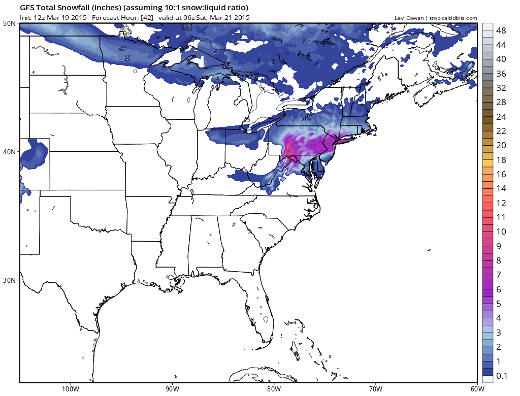
[12Z GFS snowfall forecast for tomorrow's event; map courtesy "tropicaltidbits.com", NOAA]

Discussion

Astronomical spring begins late tomorrow and old man winter is saying “not so fast”. In our transition back to a winter-like pattern, cold air made a return to the region late Tuesday night and Wednesday and now it appears very likely that accumulating wet snow will make a return on the same day that winter officially comes to an end. Accumulations are likely in all areas along the I-95 corridor and given the time of year and the fact that much of this snowfall will occur during daytime hours, they are quite likely to be highly dependent on elevation and surface type. As a result, expect wide ranges of accumulations across metro regions compared-to-normal on Friday with the highest amounts on grassy surfaces in elevated locations to the north and west of the big cities.

Low pressure will organize early Friday over the Carolinas and then gradually intensify as it moves to the northeast. Precipitation will overspread the I-95 corridor late tonight or early Friday - depending on location - and it should begin as accumulating snow in most areas. In the DC metro region, the snow will mix with and then change over to plain rain later in the morning, but it should hold on as primarily snow in the N and W suburbs of Philly and NYC during much of this upcoming event. The precipitation doesn’t wind down until later tomorrow evening in most areas. Slippery conditions can be expected on the roadways on Friday as the snow will come heavily at times during this event. On a positive note, the storm on Friday could be very photogenic. The wet nature of the snow could cling to tree limbs and surround early spring flowers that have begun to bloom.

gfs_early_afternoon 
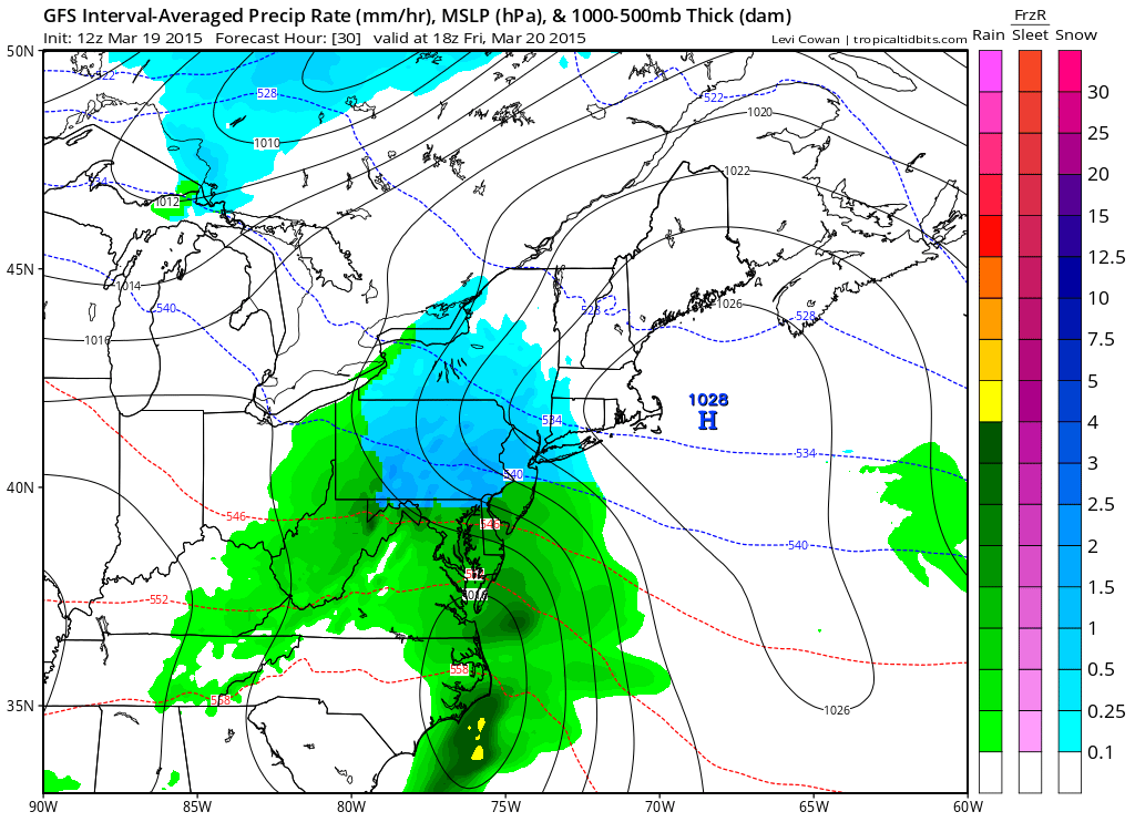
[12Z GFS forecast map for early tomorrow afternoon (blue=snow, green=rain); map courtesy "tropicaltidbits.com", NOAA]

Here are the details for each metro region in the Mid-Atlantic I-95 corridor:

DC region: Snow or rain that will quickly change to snow will develop after midnight and continue into early Friday morning. The snow should then mix with and change to plain rain later in the morning, but not before there are accumulations on the order of a coating to 2 inches in the District and nearby places to its south and east, 2-4 inches in the far N and W suburbs. The highest accumulation amounts should take place on grassy surfaces in elevated locations well to the west and north of the District. The Eastern Shore and Delmarva Peninsula regions should receive an inch or less of snowfall on Friday.

Philly region: Snow should break out right around daybreak and then continue through much of the day. There is a chance that the snow mixes with rain and/or sleet later in the day; especially, in Philly and nearby points to the south and east, but it could remain as all snow well to the north and west of the city. Accumulations expected are on the order of 2-4 inches in and around the immediate Philly metro area, 3-6 inches in the N and W suburbs. The highest accumulation amounts should take place on grassy surfaces in elevated locations well to the north and west of Philly. Southern New Jersey should receive a coating to two inches, central and northern New Jersey should end up in the 3-6 inch range.

NYC region: Snow should begin early Friday and continue through much of the day. There is a chance that the snow mixes with rain and/or sleet later in the day in the NYC metro region and nearby points to the south and east, but it is likely to remain as all snow to the north and west. Accumulations on the order of 3-6 inches are likely with the highest amounts in that range on grassy surfaces in elevated locations to the west and north of NYC.

7:00 AM | ***Winter goes out with a bang...accumulating snow late tonight/early Friday before any changeover to rain***

Paul Dorian

6-Day DC Forecast

Today

Increasing clouds, cold, highs in the mid-to-upper 40’s

Tonight

Cloudy, cold, snow or rain that will quickly change to snow develops after midnight, lows in the lower 30’s

Friday

Cloudy, cold, snow early and it should then mix with and change to plain rain, accumulations on the order of a coating to 2 inches in the District and nearby places to its south and east, 2-4 inches in the N and W suburbs, highs in the upper 30’s

Friday Night

Rain possible early, cold, low 30’s

Saturday

Partly sunny, milder, upper 50’s

Sunday

Partly sunny, colder, mid 40’s

Monday

Partly sunny, cold, mid 40’s

Tuesday

Partly sunny, cold, upper 40’s

Discussion

High pressure will shift off the coast today and this will open the door for moisture to advance northward along the coast from the southern states. Low pressure will organize near the coast on Friday and the result should be the outbreak of wet snow or rain quickly changing to wet snow after midnight in the DC metro region. The snow should continue into early Friday and then mix with and change to plain rain, but not before there are accumulations on the order of a coating to 2 inches in the District and nearby places to its south and east, 2-4 inches in the N and W suburbs. The highest amounts of accumulation should take place on grassy surfaces in higher elevation locations to the N and W of the District. Slippery conditions are likely on the roadways for the morning commute and the snow can come down hard at times. After a milder day on Saturday, another shot of cold air is destined to arrive in the region by early next week.