Contact Us

Use the form on the right to contact us.

You can edit the text in this area, and change where the contact form on the right submits to, by entering edit mode using the modes on the bottom right. 


123 Street Avenue, City Town, 99999

(123) 555-6789

email@address.com


You can set your address, phone number, email and site description in the settings tab.
Link to read me page with more information.

backlit-stratus-clouds-2013-04-05.jpg

Blog

Weather forecasting and analysis, space and historic events, climate information

Filtering by Category: DC

1:15 PM | ***Gusts to 60 mph possible with "pattern-changing" cold front***

Paul Dorian

radar[Latest NEXRAD radar image; courtesy University of Wisconsin]

Discussion

A "pattern-changing" strong cold frontal system is generating showers and embedded strong-to-severe thunderstorms from central Pennsylvania southward to Northern Virginia at mid-day and this band will move rapidly to the east into the I-95 corridor over the next few hours. Wind gusts of up to 60 mph are possible as this line of showers and storms races to the east and there can be brief downpours and small hail in scattered locations. Much colder air will quickly follow with this “pattern-changing” cold frontal passage - already down to 43 degrees in State College - and there is even snow falling across higher elevation locations of western Maryland. Colder-than-normal conditions are likely to not only last for the remainder of the week in the Mid-Atlantic region, but right through the rest of the month of April with 30’s common for overnight lows in many suburban locations to the north and west of the I-95 big cities.

7:00 AM | *Strong "pattern-changing" cold front arrives this afternoon with showers and possible strong-to-severe thunderstorms...30's again likely for lows in suburban locations for the rest of the week...below-normal temperatures expected to hold for the remainder of April*

Paul Dorian

6-Day DC Forecast

Today

Partly sunny skies today and increasingly windy, showers arrive for the afternoon and there can be a strong-to-severe thunderstorm containing wind gusts to 60 mph, small hail and brief downpours, highs in the mid-to-upper 60’s (normal high is now 68 degrees at DCA)

Tonight

An early evening shower possible then gradual clearing and turning noticeably colder, lows by morning in the upper 30's

Thursday

Partly sunny, windy, chilly, upper 50’s

Thursday Night

Partly cloudy, cold, mid 30’s

Friday

Partly sunny, breezy, chilly, mid-to-upper 50’s

Saturday

Becoming mostly cloudy, chilly, showers possible late in the day and at night, near 60 degrees

Sunday

Partly sunny, cool, low-to-mid 60's

Monday

Mainly sunny, cool, mid 60’s

Discussion

A "pattern-changing" strong cold frontal system will arrive later today in the I-95 corridor with showers and perhaps a few strong-to-severe thunderstorms containing wind gusts to 60 mph, small hail and brief downpours. The most likely timetable for this band of showers and thunderstorms to cross the DC metro region is between about noon and 5PM. Following the frontal passage, colder air will pour into the eastern states with the 30's again likely for overnight lows in suburban locations and the colder-than-normal conditions are going to hold here for the remainder of the week. In fact, once this below-normal temperature pattern sets up in the eastern states, it is likely to hold on right through the rest of the month of April.

Video

httpv://youtu.be/NLm20L47t2U

7:00 AM | Colder pattern begins with cold frontal passage on Wednesday...below-normal temperatures on Thursday, Friday and beyond

Paul Dorian

6-Day DC Forecast

Today

Mainly sunny, seasonably mild, quite breezy, highs in the upper 60’s

Tonight

Partly cloudy, quite cool late, lows in the mid 40’s

Wednesday

Partly sunny, quite breezy, a bit cooler, showers likely in the afternoon along with a possible gusty thunderstorm, mid 60’s

Wednesday Night

Mainly cloudy, chance for a shower or thunderstorm early, colder late, near 40 degrees

Thursday

Mainly sunny, breezy, chilly, upper 50’s

Friday

Mainly sunny, chilly, mid-to-upper 50’s

Saturday

Partly sunny, chilly, maybe a shower, upper 50’s

Sunday

Mainly sunny, still on the cool side, near 60 degrees

Discussion

The overall weather pattern is undergoing a transition to colder-than-normal for the eastern two-thirds of the nation and the next cold frontal passage late on Wednesday will set the stage for the change in the I-95 corridor. Temperatures today should climb to seasonably mild levels with increasing amounts of sunshine, but below-normal readings are coming our way for Thursday, Friday, Saturday and beyond. A strong cold front will arrive in the region late tomorrow with PM showers and possible gusty thunderstorms and this system will usher in colder air for the second half of the week.

Video

httpv://youtu.be/luMakZXlyDU

12:15 PM | *Threat exists in DC, Philly for severe thunderstorm activity late today/tonight*

Paul Dorian

vis0
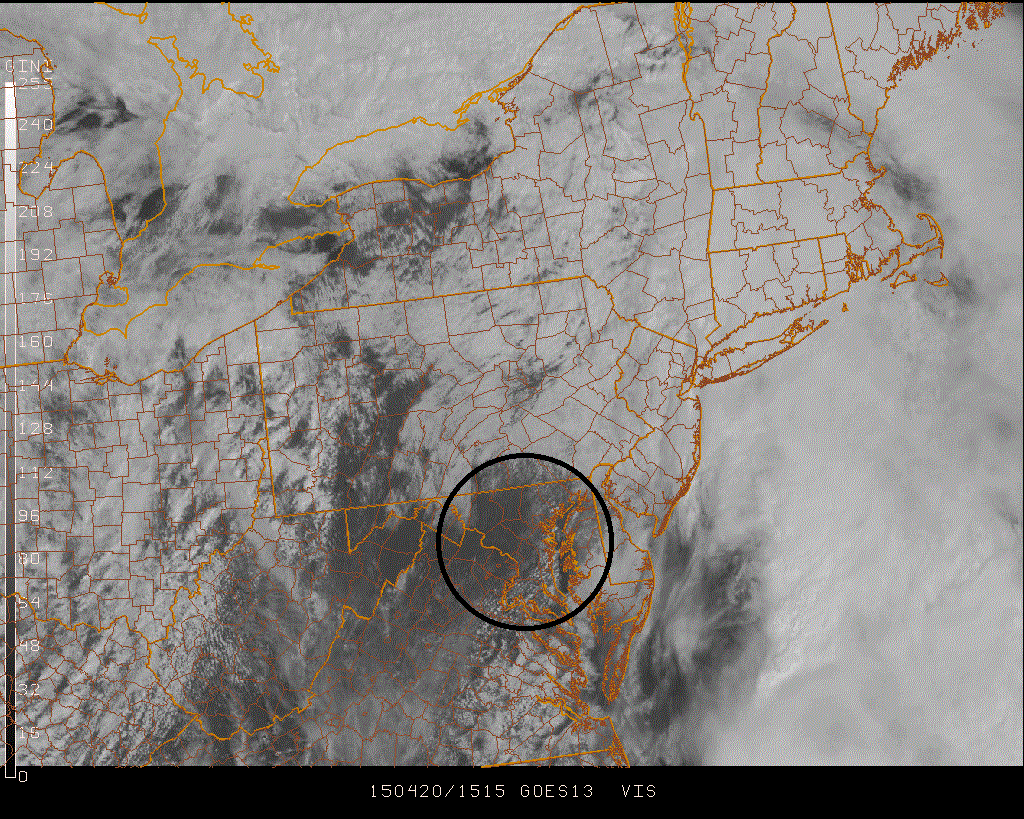
[GOES visible satellite image around noon; courtesy Penn State eWall, NOAA]

Discussion

A warm front pushed through the region this morning and sunshine has broken out across the DC metro region and is likely to appear in southeastern Pennsylvania during the afternoon. As a result, temperatures will jump to quite warm levels and this will help to destabilize the lower atmosphere ahead of the arrival of a strong cold frontal system which is now centered over the eastern Ohio Valley. The current visible satellite image shows the clearing skies across the DC metro region as of noon (circled area) and that area is expanding to the north and east. Any severe thunderstorm late today or tonight in the DC, Philly metro regions could generate damaging wind gusts, hail and possible isolated tornadoes. The latest high-resolution NAM computer forecast simulated radar map (below) for 11PM features a relatively solid line of thunderstorms near DC and just to its east as well as one line approaching southeastern Pennsylvania. The most likely time frame for any severe thunderstorm activity in the DC and Philly metro regions is between 6pm and midnight. The New York City metro region is likely to escape from any potential severe thunderstorm activity due to stubborn low cloud cover and cooler air at surface level in that area.

nam_late_evening 
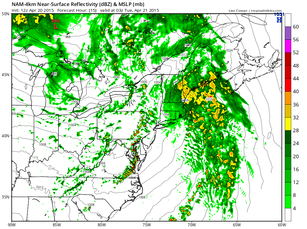
[12Z NAM simulated radar map for 11PM; map courtesy tropicaltidbits.com, NOAA]

7:00 AM | Fresh batch of showers and possible strong thunderstorms for the late day/early evening hours...colder pattern begins by mid-week

Paul Dorian

6-Day DC Forecast

Today

A mix of clouds and sun from mid-morning through early afternoon with nothing more than a lingering shower or two, showers are likely to return late this afternoon with possible strong thunderstorms, warm, highs in the mid-to-upper 70’s

Tonight

Showers and possible strong thunderstorms during the early evening hours, mild, lows in the lower 50's

Tuesday

Partly sunny, breezy, seasonably mild, upper 60’s

Tuesday Night

Partly cloudy, turning colder, low-to-mid 40’s

Wednesday

Partly sunny, a bit cooler, a few showers possible ,maybe a thunderstorm, near 65 degrees

Thursday

Partly sunny, chilly, upper 50’s

Friday

Mainly sunny, chilly, upper 50’s

Saturday

Mainly sunny, chilly, upper 50’s

Discussion

The overall weather pattern is undergoing a significant transition this week which will likely produce colder-than-normal weather conditions in the eastern two-thirds of the nation from around mid-week to the end of the month. Today’s rain event in the Mid-Atlantic region is a two-parter with the steady, soaking overnight rains associated with a warm front now over with in the DC metro region. After a break during the mid-day and early afternoon hours, a fresh batch of showers and possible strong thunderstorms will arrive for late afternoon and early evening hours (4-8pm) associated with a cold frontal system. A secondary cold front could spark some shower activity on Wednesday and then the rest of the week (and perhaps the rest of the month of April) will be colder-than-normal.

7:00 AM | Weekend starts off real well and then goes downhill...significant rain event likely on Sunday night/early Monday

Paul Dorian

6-Day DC Forecast

Today

Partly sunny skies, quite mild, an isolated shower and maybe an afternoon thunderstorm, most of the day will be rain-free, highs in the mid 70’s

Tonight

Mainly cloudy early with a lingering shower possible then partly cloudy late, mild, lows by morning in the mid 50’s

Saturday

Mostly sunny, a bit of a breeze, quite mild, upper 70’s

Saturday Night

Partly cloudy, turning colder late, upper 40’s

Sunday

Increasing clouds, noticeably cooler, rain possible late in the day and at night, mid 60’s

Monday

Periods of rain in the morning, lingering showers in the afternoon, mild, upper 60’s

Tuesday

Partly sunny, mild, chance for a shower, upper 60’s

Wednesday

Mostly sunny, cooler, low 60’s

Discussion

A weak frontal system is approaching the eastern states today and it is generating scattered showers in the Mid-Atlantic region this morning - perhaps there will be an isolated thunderstorm this afternoon. The weekend starts off real well with warm, dry conditions on Saturday, but then Sunday turns cooler along with increasing clouds. A significant rain event is likely in the DC metro region during Sunday night and early Monday as the overall weather pattern begins a transition to colder-than-normal weather which will be the dominate theme in the eastern two-thirds of the nation as we progress through the latter stages of April.

7:00 AM | Shower threat returns by late tonight...decent weekend, but overall unsettled pattern begins early next week with potential heavy rain event...colder pattern sets up for latter part of April

Paul Dorian

6-Day DC Forecast

Today

A mix of sun and clouds, comfortable temperatures, highs in the mid-to-upper 60’s

Tonight

Mostly cloudy, mild, chance for a shower late, lows by morning near 50 degrees

Friday

Mostly cloudy, mild, an occasional shower, but not a total washout, low 70's

Friday Night

Mostly cloudy, mild, chance for a shower, low-to-mid 50’s

Saturday

Mainly sunny, milder, low-to-mid 70’s

Sunday

Partly sunny, mild, chance for showers late in the day or at night, mid 60’s

Monday

Potential for a heavy rain event, mild, mid-to-upper 60's

Tuesday

Mostly cloudy, mild, chance for showers, mid-to-upper 60’s

Discussion

High pressure will control our weather for another day, but will shift off the coast by tomorrow. At the same time, the next cold frontal system will close in on the east coast and it should generate some shower activity in the Mid-Atlantic region as we close out the work week, but it will certainly not be a heavy rain event. The weekend looks quite nice, but then an overall unsettled weather pattern will develop early next week and there is the potential for a heavy rain event on Monday. This pattern change will ultimately result in much colder-than-normal weather for the eastern two-thirds of the nation during the latter part of April.

Video

httpv://youtu.be/BbL_u9TyZyI

7:00 AM | Not bad at all for the mid-week...shower threat returns by late tomorrow/tomorrow night

Paul Dorian

6-Day DC Forecast

Today

A mix of clouds and sun, mild, highs in the mid-to-upper 60’s

Tonight

Partly cloudy, cool, lows by morning in the low-to-mid 40’s

Thursday

Increasing clouds, a bit cooler, maybe a shower late, low-to-mid 60’s

Thursday Night

Mostly cloudy, cool, chance for showers, near 50 degrees for lows

Friday

Mostly cloudy, mild, chance for showers, upper 60’s

Saturday

Partly sunny, milder, chance for a couple of showers, low 70’s

Sunday

Partly sunny, mild, mid 60’s

Monday

Mostly cloudy, cooler, chance for showers, low 60’s

Discussion

A cold frontal system passed through the region on Tuesday and high pressure will build back into the Northeast US for today and Thursday. This high pressure system will move off the coastline on Friday and another frontal system will approach the eastern US bringing with it the chance for showers at the end of the work week.

7:00 AM | Occasional rain today from a slow-moving cold frontal system

Paul Dorian

6-Day DC Forecast

Today

Occasional rain today primarily before 3pm; otherwise, remaining mostly cloudy with some fog possible and a lingering shower or two, not as mild as yesterday with highs in the low-to-mid 60’s

Tonight

Mainly cloudy and quite cool with lingering showers this evening, lows by morning in the mid 40’s

Wednesday

Partly sunny, mild, low-to-mid 60’s

Wednesday Night

Partly cloudy, cool, mid 40’s

Thursday

Partly sunny, a bit cooler, maybe a shower, near 60 degrees

Friday

Mostly cloudy, milder, chance for showers, near 70 degrees

Saturday

Mostly cloudy, mild, chance for showers, upper 60’s

Sunday

Mainly sunny, seasonably mild, mid 60’s

Discussion

A cold frontal system is working its way through the I-95 corridor this morning and the result will be occasional rain in the I-95 corridor that will taper off later today from northwest-to-southeast although lingering showers can last into the early evening hours. High pressure will rebuild into the Northeast US for the mid-week time frame resulting in mainly dry conditions on Wednesday and Thursday. It’ll remain relatively mild on Wednesday, but then turn slightly cooler on Thursday ahead of the next frontal system which should generate more rain around here as we close out the work week. Longer term, a colder pattern is likely to set up for the last 10 days or so of April with below-normal temperatures likely in much of the eastern two-thirds of the nation for much of that time period.

Video

httpv://youtu.be/LE_UBSmYNxY

7:00 AM | Nice start to the week, but rain arrives early tomorrow

Paul Dorian

6-Day DC Forecast

Today

Mostly sunny, breezy, pleasant, highs in the low-to-mid 70’s

Tonight

Increasing clouds with showers possible towards morning, mild, lows in the mid 50’s

Tuesday

Periods of rain mainly before 2PM, not as mild as Monday, mid 60’s

Tuesday Night

Becoming mostly clear, quite cool, mid 40’s

Wednesday

Mostly sunny, mild, mid 60’s

Thursday

Partly sunny, cooler, upper 50’s

Friday

Mostly cloudy, mild, chance for showers, near 70 degrees

Saturday

Partly sunny, mild, chance for showers, upper 60’s

Discussion

Very nice weather to start the week, but clouds will increase tonight ahead of a cold frontal system. Rain is likely on occasion on Tuesday primarily focused on the morning and mid-day hours and some of the rain can come down heavily at times; especially, from I-95 east. High pressure builds in at mid-week before another frontal system likely affects the region late in the week.