Contact Us

Use the form on the right to contact us.

You can edit the text in this area, and change where the contact form on the right submits to, by entering edit mode using the modes on the bottom right. 


123 Street Avenue, City Town, 99999

(123) 555-6789

email@address.com


You can set your address, phone number, email and site description in the settings tab.
Link to read me page with more information.

backlit-stratus-clouds-2013-04-05.jpg

Blog

Weather forecasting and analysis, space and historic events, climate information

Filtering by Category: DC

12:00 PM | Recap of yesterday’s severe storms and spectacular sunset and also an update on the solar storm

Paul Dorian

mammatus.png

mammatus
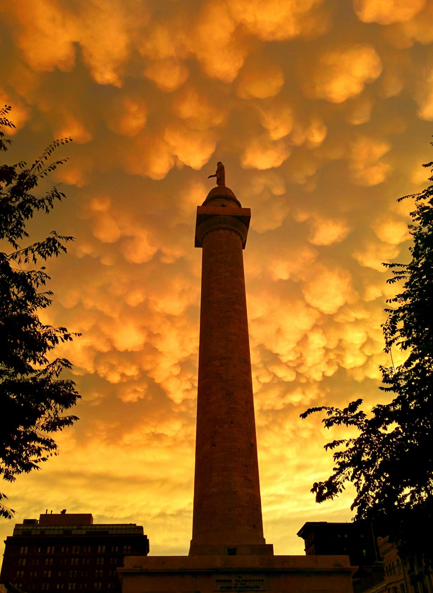
[Mammatus clouds over the Washington Monument in Baltimore, MD last night following the storms; courtesy Washington Post/Capital Weather Gang]

Discussion

Severe storms Severe weather indices were off the charts yesterday from the DC metro region eastward to southern New Jersey and northward into southeastern Pennsylvania and indeed nasty thunderstorms pounded much of this region at the end of the day. Hundreds of thousands of people lost power in this region and there were downed trees in numerous locations. Hail was not a widespread feature with this system; however, there were isolated reports of massive - perhaps record-breaking - hailstones in northern Maryland (Timonium) that were amazingly the size of a softball. Wind gusts as high as 70 mph were reported in King of Prussia, PA, 58 mph in Gaithersburg, MD, and the 5th highest gust ever recorded of 72 mph was measured at Philly International Airport. A tractor-trailer on Route I-95 in Chester, PA was overturned by the powerful winds. The National Weather Service is now investigating whether a possible tornado touched down in southern New Jersey – there were at least 4 reports of funnel clouds in southeastern PA and southern NJ.

Mammatus_23 June 2015 
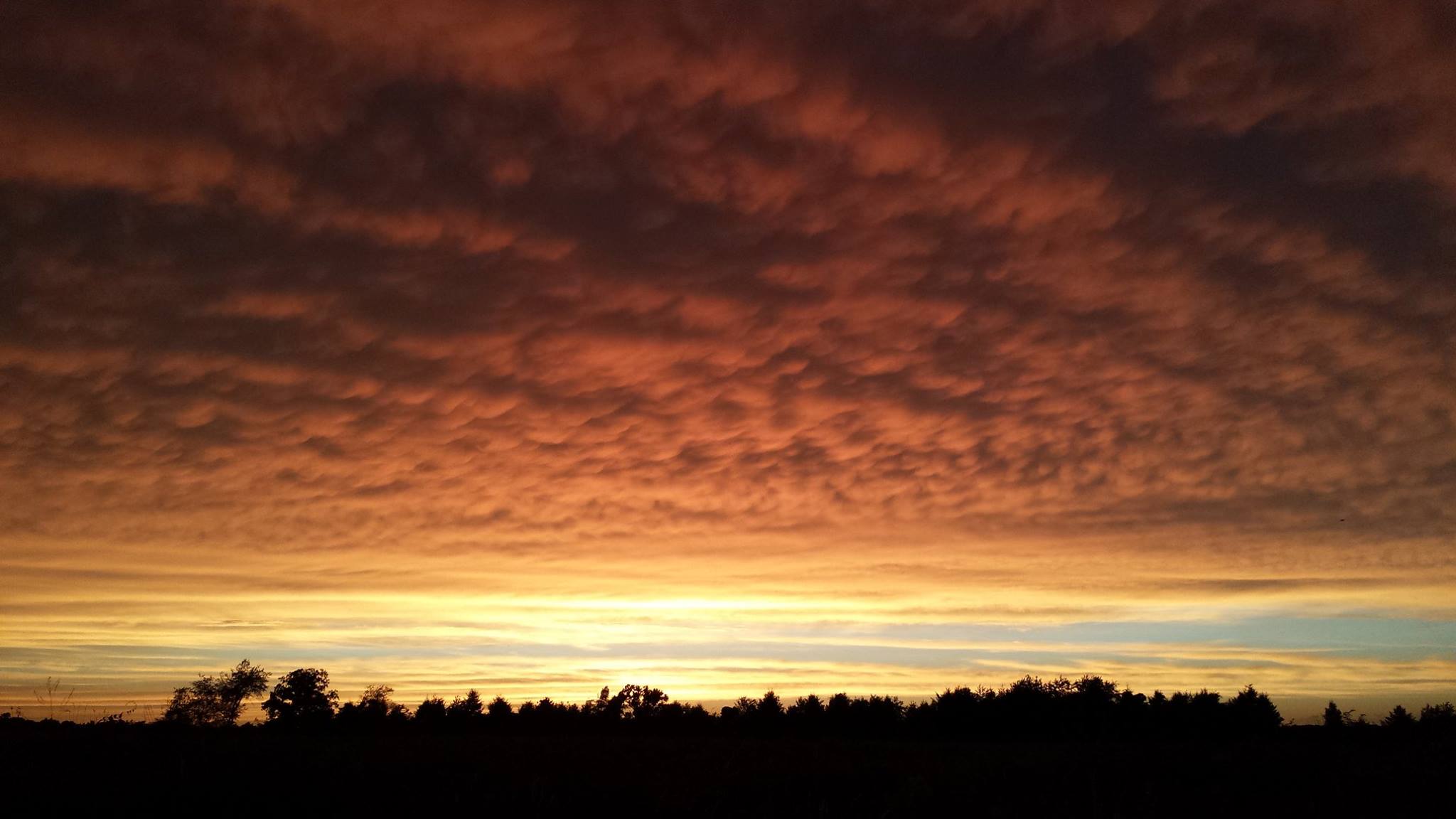
[Mammatus clouds at sunset last night in East Norriton, PA; courtesy Vencore employee John Kelley]

Spectacular sunset The sunset turned out to be quite spectacular following the powerful storms due to a lucky combination of fast-moving multiple-layered clouds and the timing of the day. There was a brief period of mammatus clouds that followed the storms and these can make for spectacular scenes at sunset. Mammatus clouds are often associated with severe weather and are typically seen following storms in areas of sinking air. These clouds look like small pouches hanging beneath a deck of higher clouds and they form as air in the cloud cools and sinks. As the sun reached the horizon, the sky colors tended to change from an orange/yellow to a pink or red.

Solar storm A huge solar storm erupted on the sun this past Sunday – perhaps the biggest since 2005 – and it sent waves of plasma towards the Earth that have produced northern lights in many mid and high latitude locations. Computer forecast modeling suggests another coronal mass ejection (CME) will arrive at the Earth’s magnetic field early tonight and this could generate more northern lights. The intensity of the storm is always hard to predict, but aurora watchers should be on alert and skies should cooperate through the night. Oregon 
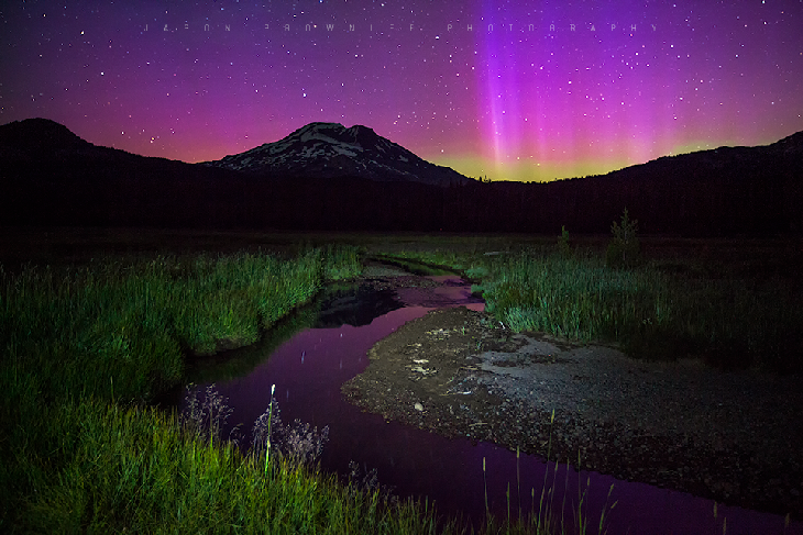
[Northern lights as seen last night in Oregon; courtesy spaceweather.com]

7:00 AM | Much calmer today with less humidity...cool, wet spell for Friday, Saturday, Sunday

Paul Dorian

6-Day DC Forecast

Today

Mainly sunny, still quite warm, but much more comfortable than yesterday with noticeably lower humidity, highs in the upper 80’s

Tonight

Mainly clear, pleasantly cool, lows near 65 degrees

Thursday

Increasing clouds, warm, chance for late day or nighttime showers and thunderstorms, mid 80’s

Thursday Night

Mainly cloudy, mild, chance for showers and thunderstorms, upper 60’s

Friday

Mostly cloudy, cooler, showers likely and possibly some steadier rain, near 80 degrees

Saturday

Mostly cloudy, cool, showers likely and possibly some steadier rain, mid 70’s

Sunday

Mostly cloudy, cool, showers still possible, mid 70’s

Monday

Partly sunny, cool, chance for showers, upper 70’s

Discussion

A strong cool front passed through the Mid-Atlantic region late yesterday associated with a fresh round of showers and thunderstorms. Although today will remain quite warm, it’ll feel much more comfortable with noticeably lower humidity values. Temperatures will continue to trend downward later in the week and a complex low pressure system setting up near the east coast by the weekend could bring us a spell of cool, wet weather from Friday through the upcoming weekend.

Looking even farther ahead, this late week change to a cooler weather pattern in the Northeast US will stick around as we progress through the first part of July. While we turn cooler in the Northeast and Midwest, the Pacific Northwest will become hot and dry under the domain of a strong upper-level ridge of high pressure. Finally, the sun has had an active few days as a large sunspot region produced a G4-class geomagnetic storm on Sunday and northern lights may be visible again tonight from a second wave of plasma expected to arrive this evening.

12:45 PM | **An update on today's serious severe thunderstorm threat and on the latest solar storm**

Paul Dorian

solar_image.gif

CAPE
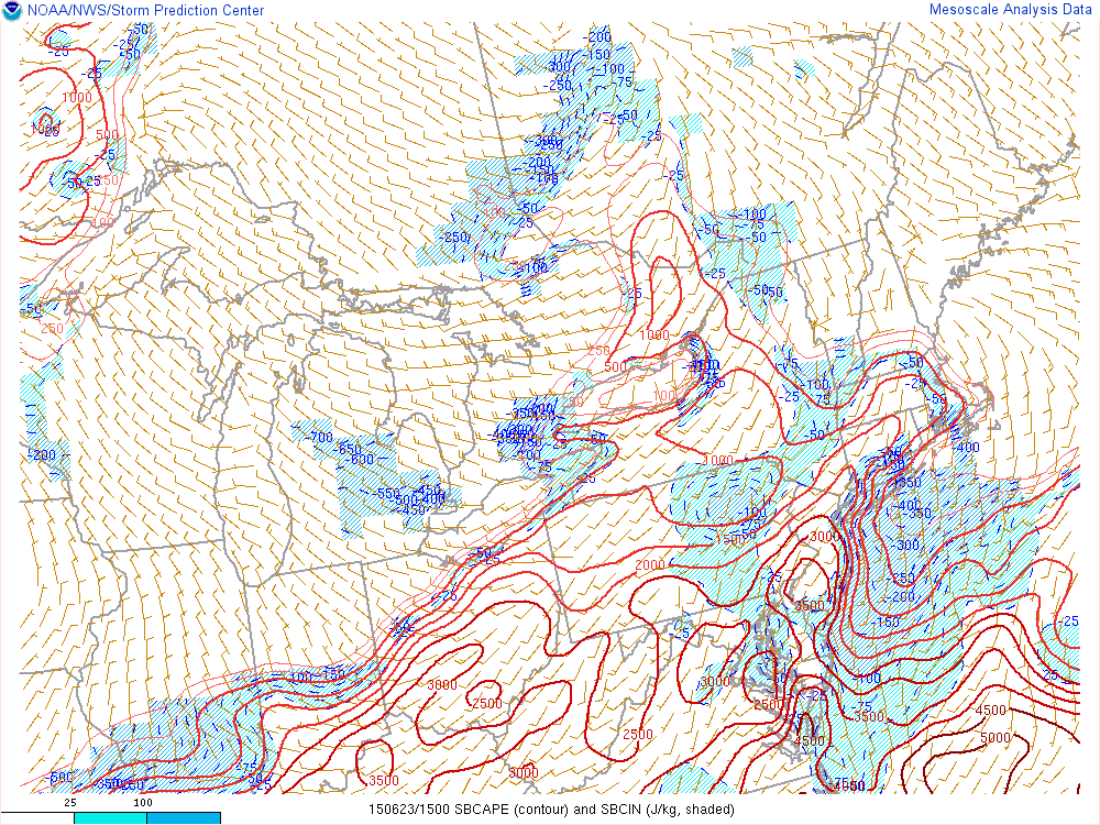
[Current Convective Available Potential Energy (CAPE) index values; courtesy NOAA]

Discussion

Severe weather threat Severe weather indices are often quite useful to weather forecasters in the determination of atmospheric instability and several of these are raising serious red flags for the I-95 corridor for later today/early tonight. One such index is called Convective Available Potential Energy (CAPE) and readings above 2500 are considered to be “extreme” and suggestive of a very unstable atmosphere. Currently, CAPE readings (above) exceed 3000 in much of the area from DC eastward to southern New Jersey and northward into southeastern Pennsylvania. In addition, the Lifted Index (LI) is typically regarded as indicative of “extreme instability” when calculated at -8 or less and the current map (below) shows “extreme” levels of -8 or -9 in the same general region from DC eastward to southern New Jersey and northward into southeastern Pennsylvania. All of this makes the entire Philly metro region, southern New Jersey, the DC metro region, and the Delmarva Peninsula especially vulnerable late today/early tonight to some nasty thunderstorm activity. The timetable for the potential severe thunderstorm activity is the usual summertime "prime time" period of 5-9pm. Any thunderstorm later today/early tonight in the I-95 corridor can contain torrential downpours with flash flooding, frequent lightning with possible power outages, damaging wind gusts, hail and there can even be isolated tornadoes during this event.

LI 
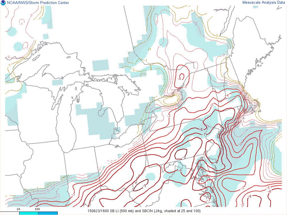
[Current Lifted Index (LI) values; courtesy NOAA]

solar_image 
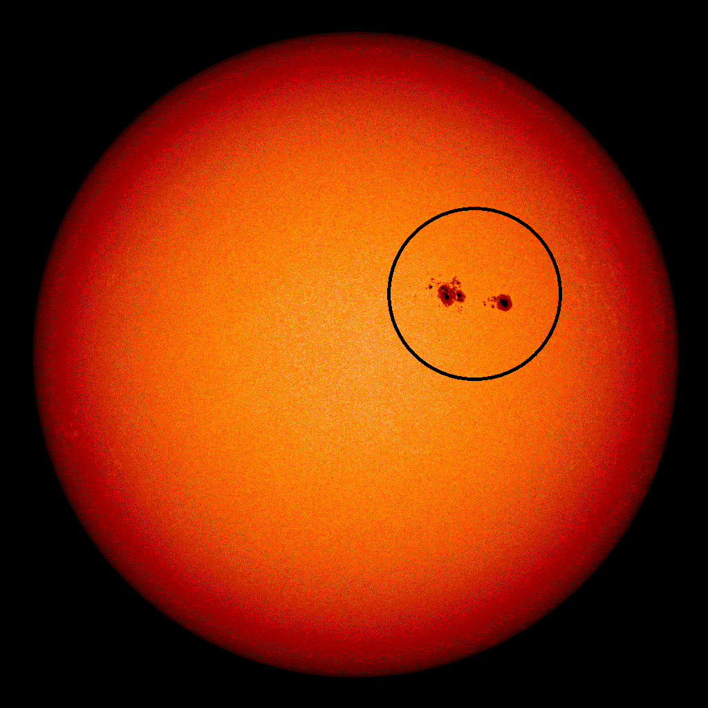
[Latest solar image with active sunspot region circled; courtesy NOAA]

Solar storm In addition to the lower atmosphere instability being experienced today in the Mid-Atlantic region, the upper atmosphere around here and all the way to the North Pole has been affected by a series of coronal mass ejections (CMEs) since Sunday which created northern lights last night as far south as Georgia. In general, the latest image of the sun (above) is actually rather quiet-looking except for one large and active sunspot region (circled) that has been directly facing the Earth in recent days and the culprit of this latest solar outburst. The interesting part of the story here is that NOAA modeling of the June 22 CME suggests another outburst will arrive early tomorrow night and this could cause a renewed round of northern lights across many mid and high latitude locations. The lower left image below depicts the Earth as a small green circle (arrow) with lots of "yellows and reds" representing the plasma associated with the recent coronal mass ejection and it has it arriving by around 7pm tomorrow night. Bottom line…if you’re an aurora watcher you might want to check things out tomorrow night (and skies should cooperate) and perhaps even after midnight later tonight when skies should clear following late afternoon and evening thunderstorms.

solar_storm 
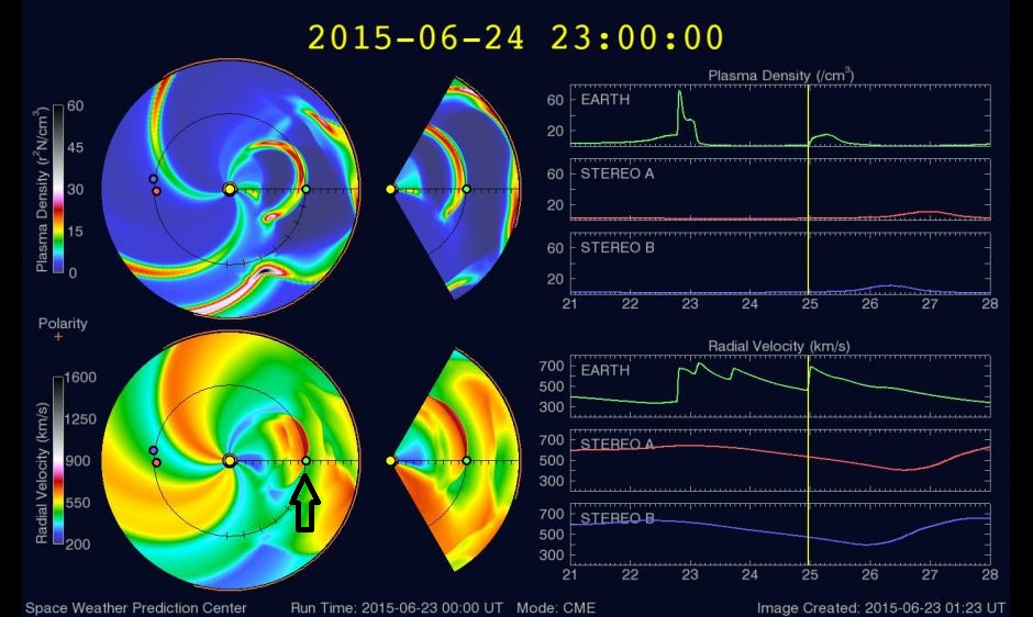
[NOAA forecast model of coronal mass ejection; courtesy NOAA Space Prediction Center]

7:00 AM | Late day/early evening showers and thunderstorms some of which can be strong-to-severe...cooling trend later in the week with a possible cool, wet weekend on its way

Paul Dorian

6-Day DC Forecast

Today

Partly sunny, hot, humid, a fresh round of showers and thunderstorms likely late in the day and some of the storms can be on the strong-to-severe side, highs in the middle 90’s

Tonight

Evening showers and thunderstorms still possible, some of the storms can be on the strong-to-severe side, becoming partly cloudy after midnight, lows late in the upper 60’s

Wednesday

Mainly sunny, still quite warm, but much more comfortable with lower humidity, upper 80’s

Wednesday Night

Partly cloudy, pleasant, mid-to-upper 60’s

Thursday

Increasing clouds, warm, chance for late day or nighttime showers and thunderstorms, mid 80’s

Friday

Mostly cloudy, cooler, showers likely and possibly some steadier rain, low 80’s

Saturday

Mostly cloudy, cool, showers likely and possibly some steadier rain, mid-to-upper 70’s

Sunday

Mostly cloudy, cool, showers still possible, mid-to-upper 70’s

Discussion

Today should turn out to be the hottest day of the week with temperatures soaring into the 90’s; however, an end to this hot weather is on its way with the passage of a strong cool frontal system. That front is likely to produce a fresh round of showers and thunderstorms later today and early tonight and some of the storms can be on the strong-to-severe side in the I-95 corridor with damaging wind gusts, heavy downpours and possible hail. Tomorrow will remain quite warm, but much more comfortable than today with noticeably lower humidity values following the frontal passage. Temperatures will continue to trend downward later in the week and a complex low pressure system setting up near the east coast by the weekend could bring us a spell of cool, wet weather from Friday through the upcoming weekend.

Looking even farther ahead, this late week change to a cooler weather pattern in the Northeast US will stick around as we progress through the first part of July. While we turn cooler in the Northeast and Midwest, the Pacific Northwest will become hot and dry under the domain of a strong upper-level ridge of high pressure. Finally, the sun has had an active couple of days as a large sunspot region produced a G4-class geomagnetic storm on Sunday and northern lights were seen last night as far south as Georgia.

Video

httpv://youtu.be/52FTDIdZnNI

7:00 AM | Week starts off quite hot with plenty of sunshine; the hot weather will then give way to a cooler second half of the week

Paul Dorian

6-Day DC Forecast

Today

Mainly sunny, quite warm, highs near 90 degrees

Tonight

Partly cloudy, mild, lows in the lower 70's

Tuesday

Partly sunny, hot, humid, a fresh round of showers and thunderstorms late and some of the storms can be strong, near 95 degrees

Tuesday Night

Evening showers and thunderstorms and some of the storms can be on the strong side then becoming partly cloudy, mild, lows late in the mid-to-upper 60's

Wednesday

Mainly sunny, more comfortable with lower humidity, mid 80's

Thursday

Partly sunny, not as warm, humid, chance for showers and thunderstorms, low-to-mid 80’s

Friday

Mostly cloudy, cooler, humid, chance for showers and thunderstorms, near 80 degrees

Saturday

Mostly cloudy, cool, chance for showers and thunderstorms, upper 70's

Discussion

The weather this week will start off quite warm with plenty of sunshine and temperatures climbing to the 90 degree mark. A cold front will approach late Tuesday and it should set off a fresh round of showers and thunderstorms and some of the storms can be on the strong side. Temperatures will trend downward during the second half of the week with below normal highs for much of the time. Another frontal system will keep things unsettled around here later in the week with the possibility of additional showers and thunderstorms.

7:00 AM | **The remains of Tropical Storm Bill headed our way for late Saturday night and early Sunday**

Paul Dorian

6-Day DC Forecast

Today

Partly sunny, noticeably warmer than yesterday, slight chance for a shower or thunderstorm, highs in the mid-to-upper 80’s

Tonight

An evening shower or thunderstorm possible; otherwise, partly cloudy skies, mild, lows not far from 65 degrees

Saturday

Partly sunny, warm, humid, chance for showers and thunderstorms late in the day, mid 80’s

Saturday Night

Mostly cloudy skies with the chance for showers and thunderstorms; especially, late at night, some of the rain can be heavy, mild, muggy, near 70 degrees

Sunday

Periods of rain and possible thunderstorms primarily during the morning hours, some of the rain can be heavy at times, very warm with tropical-like humidity levels, upper 80’s

Monday

Mostly sunny, very warm, near 90 degrees

Tuesday

Mainly sunny, very warm, near 90 degrees

Wednesday

Mainly sunny, warm, mid 80’s

Discussion

A warm front pushed through the area on Thursday and the result will be noticeably warmer weather conditions today in the Mid-Atlantic region to close out the work week and the slight chance for another shower or thunderstorm. Meanwhile, the remains of Tropical Storm Bill continue to trek slowly to the northeast across the south-central states and it appears as though they’ll push into the I-95 corridor region of DC, Philly and NYC by Father's Day. As a result, the threat exists for periods of heavy rain late Saturday night and early Sunday with embedded thunderstorms and localized flooding conditions. Total rainfall amounts in the I-95 corridor from this system can certainly reach a few inches in a relatively short period of time. The afternoon on Sunday may actually turn out to be pretty decent following the expected heavy rainfall. The rain will be accompanied by tropical-like warmth and humidity levels. Following the “tropical” activity on Sunday, the first half of next week looks quite warm and generally rain-free in the Mid-Atlantic region.

Video

httpv://youtu.be/MRqZh2hBCik

7:00 AM | Tracking the remains of Tropical Storm Bill...heavy rain possible on Sunday in the Mid-Atlantic region

Paul Dorian

6-Day DC Forecast

Today

Mainly cloudy with showers likely this morning, a shower or thunderstorm possible this afternoon, warm, humid, highs in the mid-to-upper 80’s

Tonight

Chance for showers and thunderstorms, mild, lows in the upper 60’s

Friday

Partly sunny, quite warm, chance for a shower or thunderstorm, upper 80’s

Friday Night

Mostly cloudy, mild, muggy, chance for showers and thunderstorms, upper 60’s

Saturday

Partly sunny, warm, humid, chance for showers and thunderstorms late in the day or at night, mid 80’s

Sunday

Mostly cloudy, quite warm, tropical-like humidity, chance for rain and thunderstorms, some of the rain can be heavy, upper 80's

Monday

Partly sunny, quite warm, humid, chance for showers and thunderstorms, upper 80's

Tuesday

Partly sunny, quite warm, slight chance for showers and thunderstorms, mid 80’s

Discussion

After a welcome break in the active weather pattern on Wednesday, a warm front is pushing through the region this morning causing some steady light rain or drizzle and a weak cool front will approach on Friday. This next cool front will then stall in the area this weekend and moisture associated with the remains of Tropical Storm Bill will likely ride right along the frontal boundary zone late in the weekend. As a result, there is the threat for periods of heavy rain and thunderstorms on Father's Day Sunday from the remains of Tropical Storm Bill.

12:00 PM | Potential for heavy rainfall from tonight into early Thursday and then again late Saturday night/early Sunday

Paul Dorian

us3comp.gif

us3comp
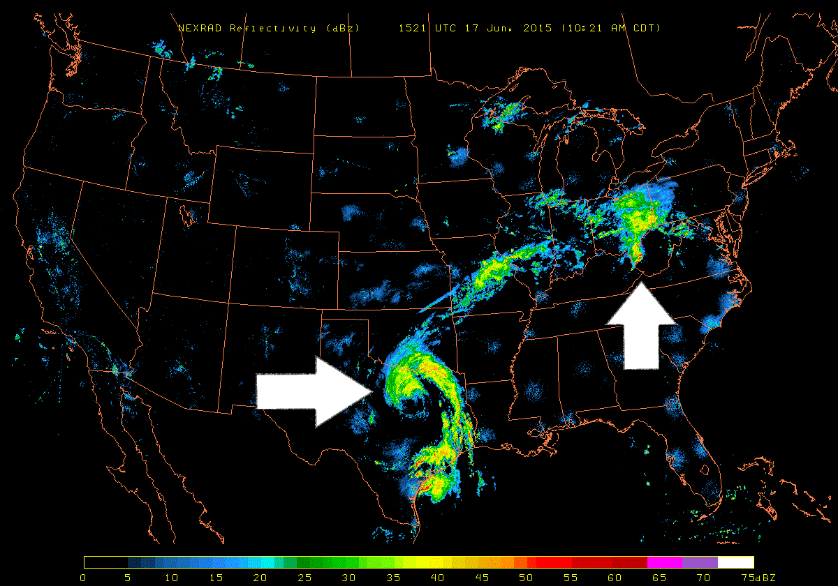
[Mid-day NEXRAD (radar) image; courtesy University of Wisconsin]

Discussion

The latest NEXRAD image across the US shows two impressive moisture fields and both could end up affecting the I-95 corridor region from DC-to-Philly-to-NYC. The first area of interest is seen at mid-day over the Ohio Valley and it is associated with an advancing warm frontal system. This area of rainfall is moving eastward at a pretty good clip and could very well produce downpours in much of the I-95 corridor from tonight into early Thursday. The second area of interest can be seen as a "spiral" over eastern Texas at mid-day and it is associated with the remains of Tropical Storm Bill. It is quite likely that this area of moisture moves northeast over the next few days and reaches the I-95 corridor late Saturday night and early Sunday with more heavy rainfall and possible strong thunderstorm activity. Stay tuned.

7:00 AM | More comfortable today, but shower/storm threat returns quickly...weekend could include the remains of Tropical Storm Bill

Paul Dorian

6-Day DC Forecast

Today

Increasing clouds, warm and less humid, chance for showers and thunderstorms late, highs in the mid 80’s

Tonight

Showers likely and maybe a thunderstorm, mild, becoming muggy by morning, lows in the mid-to-upper 60’s

Thursday

Mostly cloudy, warm, humid, chance for showers and thunderstorms, upper 80’s

Thursday Night

Chance for showers and thunderstorms, mild, muggy, near 70 degrees

Friday

Mainly cloudy, warm, humid, chance for more showers and thunderstorms, mid-to-upper 80’s

Saturday

Mainly cloudy, warm, periods of rain possible late in the day or at night, maybe a thunderstorm, all depending on the movement of the remains of Tropical Storm Bill, mid-to-upper 80’s

Sunday

Mostly cloudy, quite warm, humid, chance for rain and thunderstorms depending on the movement of the remains of Tropical Storm Bill, near 90 degrees

Monday

Partly sunny, quite warm, humid, chance for showers and thunderstorms, near 90 degrees

Discussion

A cool front passed through the area late yesterday and much more comfortable air has pushed into the Mid-Atlantic region. This break in the overall active weather pattern will not last too long; however, as the front will return northward as a warm front later today and this will renew the chances for rain and thunderstorms by early tonight. It’ll stay somewhat unsettled on Thursday and Friday as well with the chance for showers and a thunderstorm each day and then attention will turn to the impressive moisture field associated with Tropical Storm Bill which has pounded Texas with heavy rainfall. This area of moisture is likely to get pushed to the north and east over the next few days by upper-level winds and it could very well generate some heavy rainfall in the Mid-Atlantic region late Saturday into Sunday.

1:00 PM | Weekend heavy rain threat with a tropical connection

Paul Dorian

avn0-lalo.gif

avn0-lalo
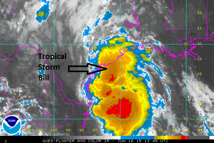
[Latest colorized IR satellite image; courtesy Penn State eWall]

Discussion

Tropical Storm Bill is pushing ashore at this hour over the central Texas coastline bringing with it torrential rainfall and renewed concerns for flooding. The latest colorized infrared satellite image (above) shows an extensive area of high clouds (reds, oranges) over the Gulf of Mexico associated with strong thunderstorm activity near the tropical system. The strongest winds associated with Bill are likely to occur to the east of the storm track where gusts can reach 65 mph or so as the system moves inland. The heaviest rainfall likely to fall over the next 24 hours or so will be on areas that suffered through flooding rains in May such as eastern Texas, northwestern Louisiana and southeastern Oklahoma. Some of these locations could receive more than a foot of rain on top of the 1-2 feet of rain experienced there back in May.

After the storm moves inland, it’ll transition to a non-tropical system, but flooding rainfall will continue in its path. Bill’s immediate moisture field is likely to advance to the north and east as it gets influenced by southwesterly upper-level winds. In fact, there is already an impressive moisture field that extends from the Texas coastline to the Mid-Atlantic region as indicated below by the blueish-green colors on the following wind flow and precipitable water map. Note the circulation center at the Texas coastline associated with Tropical Storm Bill.

PW 
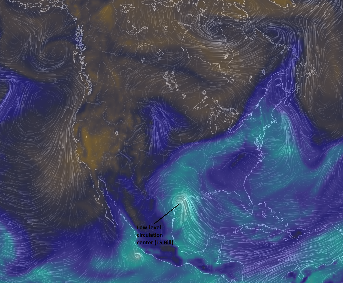
[Low-level wind flow and precipitable water; courtesy earth.nullschool.net]

There is the chance that heavy rainfall from the remains of Tropical Storm Bill will reach the Mid-Atlantic region sometime this weekend. The latest GFS computer model forecast (below) depicts an area of heavy rainfall in the Mississippi Valley by early Friday afternoon (top, circled area) that then progresses to the I-95 corridor region by early Sunday morning (bottom, circled area). Stay tuned.

Picture1 
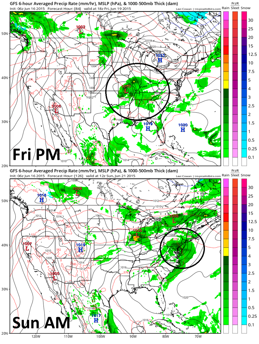
[GFS forecast maps for early Friday PM (Top) and early Sunday morning (bottom); courtesy NOAA]