Contact Us

Use the form on the right to contact us.

You can edit the text in this area, and change where the contact form on the right submits to, by entering edit mode using the modes on the bottom right. 


123 Street Avenue, City Town, 99999

(123) 555-6789

email@address.com


You can set your address, phone number, email and site description in the settings tab.
Link to read me page with more information.

backlit-stratus-clouds-2013-04-05.jpg

Blog

Weather forecasting and analysis, space and historic events, climate information

Filtering by Category: DC

7:00 AM | Frontal system showers later today, maybe a gusty thunderstorm...cool weekend follows

Paul Dorian

6-Day DC Forecast

Today

Mainly cloudy, warmer, breezy, more humid, good chance for mid-to-late afternoon showers, maybe a brief, gusty thunderstorm, highs in the upper 70’s

Tonight

Showers still possible early, maybe a thunderstorm; otherwise, clouds give way to some clearing skies, turning cooler late, lows by morning in the lower 50’s

Saturday

Partly sunny, breezy, quite cool, low-to-mid 60’s

Saturday Night

Mainly clear, quite chilly with the lowest temperatures of the season so far, lows not far from 40 degrees

Sunday

Mainly sunny, cool, upper 60’s

Monday

Mainly sunny, pleasant, low 70's

Tuesday

Partly sunny, comfortable, low 70's

Wednesday

Partly sunny, a bit cooler, mid-to-upper 60’s

Discussion

A strong cool front will arrive in the Mid-Atlantic region today and it is going to break our recent dry spell with occasional showers and perhaps a brief, gusty thunderstorm or two - gusts can reach 50+ mph in isolated spots. This does not look like a significant rain event and it should pull out of here in time for a decent, but quite cool weekend. In fact, temperatures late Saturday night/early Sunday morning are likely to drop to the lowest levels of the season so far with lows not far from the 40 degree mark in many spots. Another cool front arrives on Tuesday of next week and it will be followed by another cool air mass for the mid-week time period.

Video

httpv://youtu.be/kDE8L3m9tUQ

7:00 AM | Quite a cool air mass follows for the weekend after Friday showers

Paul Dorian

6-Day DC Forecast

Today

Mainly sunny, comfortable, highs in the mid 70’s

Tonight

Increasing clouds, cool, lows in the middle 50’s

Friday

Mainly cloudy, warmer, more humid, good chance for showers, maybe a thunderstorm, upper 70’s

Friday Night

Mostly cloudy with early showers possible, turning cooler late, lows by morning near 55 degrees

Saturday

Early clouds give way to sunshine, breezy, quite cool, mid 60’s

Sunday

Mainly sunny, cool, upper 60’s

Monday

Mainly sunny, pleasant, low-to-mid 70’s

Tuesday

Mostly sunny, comfortable, low 70’s

Discussion

A strong cool front will approach the region on Friday and it is likely to generate numerous showers and possibly a thunderstorm or two; however, this does not look like a signficant rain event. This front will be followed by a cool air mass for the weekend as high pressure builds back into the area.

7:00 AM | Next threat for showers comes on Friday...rocket launch tonight at NASA/Wallops may be visible here

Paul Dorian

6-Day DC Forecast

Today

Clouds this morning will give way to partly sunny skies, warm, highs in the mid 70’s

Tonight

Partly cloudy, quite cool late, lows in the lower 50’s

Thursday

Mainly sunny, a bit cooler, low-to-mid 70’s

Thursday Night

Partly cloudy, cool, mid 50’s

Friday

Mainly cloudy, warm, more humid, good chance for showers, maybe a thunderstorm, mid 70’s

Saturday

An early shower possible; otherwise, becoming partly sunny, breezy, cooler, mid 60’s

Sunday

Mainly sunny, cool, mid-to-upper 60’s

Monday

Mainly sunny, comfortable, low 70's

Discussion

Our overall quiet and dry weather pattern will continue for the next couple of days as high pressure across the northern tier of the US continues to have an influence on our weather here in the DC metro region. A strong cold front approaches on Friday and it is likely to generate numerous showers in the region and then a cool air mass will follow for the upcoming weekend.

One final note…there is a launch scheduled for this evening (7-9pm) at the NASA/Wallops facility and it could be visible in the DC metro region depending upon cloud cover (look low in the southeastern sky). In addition, one of the main purposes of this experiment is to generate "glowing vapor” clouds which also may be visible in this region way up in the sky. For more info: http://vencoreweather.com/2015/10/05/1245-pm-nasa-launch-tomorrow-evening-should-be-visible-in-the-mid-atlantic-region/

7:00 AM | Quiet weather continues

Paul Dorian

6-Day DC Forecast

Today

Mainly sunny, nice, highs in the low-to-mid 70’s

Tonight

Partly cloudy, cool, lows in the lower 50's

Wednesday

Partly sunny, pleasant, mid 70’s

Wednesday Night

Partly cloudy, cool, low 50’s

Thursday

Mainly sunny, nice, near 75 degrees

Friday

Mainly cloudy, more humid, good chance for showers, low-to-mid 70’s

Saturday

Mainly sunny, a bit cooler, mid 60’s

Sunday

Mainly sunny, comfortably cool, mid-to-upper 60’s

Discussion

High pressure centered over northern New England remains in control of our weather today, but it’ll push away tomorrow and a weak cold front will cross the area. While this mid-week front is likely to come through on the dry side, a stronger front will approach on Friday and it is quite likely to generate numerous showers in the Mid-Atlantic region. One final note…the launch originally set for tonight at NASA/Wallops has been postponed until tomorrow night.

7:00 AM | A much quieter week in store for the region

Paul Dorian

6-Day DC Forecast

Today

Becoming mainly sunny, comfortably cool, highs in the mid 60’s

Tonight

Mainly clear, cool, lows in the upper 40's

Tuesday

Mainly sunny, pleasant, low-to-mid 70's

Tuesday Night

Partly cloudy, cool, near 50 degrees

Wednesday

Mainly sunny, nice, mid 70's

Thursday

Mainly sunny, comfortable, low 70's

Friday

Mainly cloudy, cool, good chance for showers, near 70 degrees

Saturday

Partly sunny, a bit cooler, upper 60’s

Discussion

Hurricane Joaquin continues to trek across the Atlantic Ocean this morning now to the northwest of Bermuda and high pressure will build into the Mid-Atlantic region over the next couple of days. The bullseye of the weekend rainfall occurred over South Carolina where 2 feet of rain fell in spots aided by a deep, slow-moving upper-level trough and stationary strong high pressure to the north. It is likely to stay rain-free around here for much of the week with the next good chance for showers coming on Friday as a cold front approaches the region.

7:00 AM | **Rain, wind in the Mid-Atlantic region...Joaquin continues to churn over the western Atlantic..."out to sea" solution still most likely**

Paul Dorian

6-Day DC Forecast

Today

Cloudy, windy, quite cool, periods of rain, some of the rain will be heavy at times, highs in the middle 50’s

Tonight

Cloudy, windy, cool, periods of rain, some of the rain will be heavy at times, lows near 50 degrees

Saturday

Cloudy, windy, quite cool, periods of rain still likely, upper 50's

Saturday Night

Cloudy, windy, cool, showers possible, mid-to-upper 50’s

Sunday

Considerable clouds, windy, cool, showers possible, low-to-mid 60’s

Monday

Partly sunny, windy, cool, chance of showers, mid-to-upper 60’s

Tuesday

Partly sunny, pleasant, upper 60’s

Wednesday

Mostly sunny, nice, near 70 degrees

Discussion

Hurricane Joaquin continues to churn near the Bahama Islands as a category 4 storm and is under the influence of weakening upper-level ridging, but soon it will come under the influence of an upper-level trough. Once this upper-level trough approaches the hurricane, it will likely turn northward and then northeast away from the US east coast. In the meantime, the combination of a cold front, strong high pressure to the north, and a "nor'easter-like" low pressure system will produce heavy rainfall and strong onshore winds in the Mid-Atlantic region right into tomorrow. Rainfall amounts of one to as much as four inches are possible in the I-95 corridor from this setup by later tomorrow (the higher amounts near DC, the lesser amounts near NYC). Winds will remain persistent out of the northeast over the next 24 hours with 35 mph gusts at inland locations and 50 mph gusts at the coast. Farther south, staggering amounts of rain can fall over the next few days with 1-2 feet possible in parts of the Carolinas and widespread flooding is quite likely in that part of the country.

Video

httpv://youtu.be/J_ZTu9d0aWQ

12:40 PM | **“Out to sea” solution for Hurricane Joaquin continues to look viable**

Paul Dorian

Joaquin.png

Joaquin
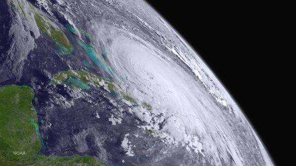
[Satellite image of Hurricane Joaquin from GOES West; courtesy NOAA]

Discussion

Hurricane Joaquin has strengthened slightly in the past few hours with sustained winds now at 125 mph and central pressure at 27.82 inches. Joaquin (image above) has moved slowly to the southwest during the past several hours, but the shortwave ridge causing this motion is weakening and an upper-level trough is developing over the Southeast US. Once this upper-level trough becomes well-established by the weekend, it is likely to begin to influence Joaquin's movement. In fact, the hurricane is likely to turn northward on a track towards the US east coast early in the weekend; however, odds are increasing that Joaquin will then steer away from the coast later in the weekend without ever making landfall.

In the meantime, the combination of a cold front, strong, stationary high pressure to the north, and a "nor'easter-like" low pressure system will produce heavy rainfall and increasingly strong onshore winds in the Mid-Atlantic region from later today into Saturday as the pressure gradient tightens between the high and low. Rainfall amounts of one to three inches are possible in the I-95 corridor between now and early Saturday (higher near DC, lower near NYC) and there can be minor-to-moderate coastal flooding. Winds will be persistent out of the northeast with 30 mph gusts possible at inland locations by the weekend and up to 50 mph at the coast.

Farther south, staggering amounts of rain can fall over the next several days with 1-2 feet possible in parts of the Carolinas and widespread flooding is quite likely in that part of the country. Should Joaquin ever impact the Mid-Atlantic region with a direct hit – and odds are slowly diminishing - it would be in the Sunday-Tuesday time frame. Indeed, odds are probably better right now for some sunshine in the Mid-Atlantic region by the time Sunday afternoon rolls around rather than "stormy" conditions associated with Joaquin; however, stay tuned as this is a slow-moving dangerous hurricane that comes awfully close to the coast for comfort.

145823W5_NL_sm 
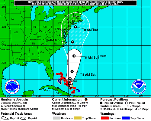
[The latest track of Joaquin from NOAA's Hurricane Center].

7:00 AM | ***Significant rain and wind for the Mid-Atlantic from initial system...Hurricane Joaquin could stay out to sea***

Paul Dorian

Joaquin
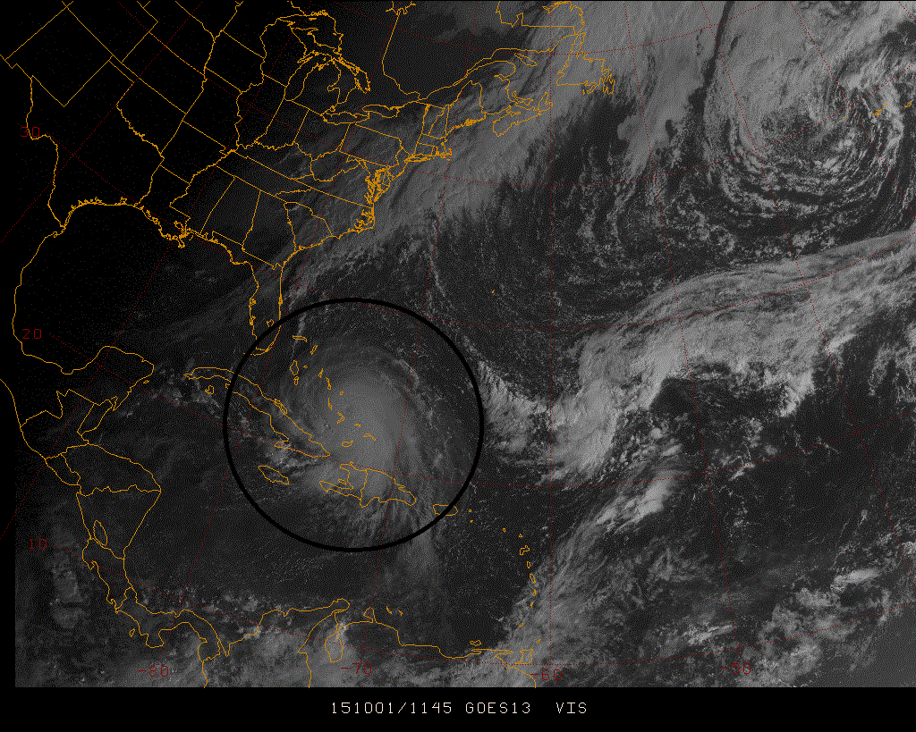
[Latest visible satellite image of Hurricane Joaquin; courtesy Penn State eWall]

6-Day DC Forecast

Today

Cloudy, breezy, quite cool, occasional showers, highs near 60 degrees

Tonight

Cloudy, windy, cool, periods of rain, lows in the lower 50’s

Friday

Cloudy, windy, quite cool, periods of rain, mid 50's

Friday Night

Cloudy, windy, cool, periods of rain, low 50’s

Saturday

Cloudy, windy, cool, showers likely, low-to-mid 60’s

Sunday

Cloudy, windy, cool, more rain possible depending on the track of Joaquin, mid-to-upper 60’s

Monday

Cloudy, windy, cool, more rain possible depending on the track of Joaquin, mid-to-upper 60’s

Tuesday

Partly sunny, cool, still the threat for showers, upper 60’s

Discussion

The combination of a cold front, strong high pressure to the north, and a "nor'easter-like" low pressure system will produce heavy rainfall and strong, long-lasting onshore winds in the Mid-Atlantic region from later today into Saturday. Beyond that, another round of heavy rain and strong winds is possible here depending on the track of Hurricane Joaquin; however, there is the chance that this tropical system stays out to sea.

Hurricane Joaquin strengthened overnight into a category 3 ("major") hurricane now with sustained winds of 120 mph. It continues on a southwest track at slow speeds, but soon will be changing direction as deep upper-level low sets up in the Southeast US. Once Joaquin is captured by the deep upper-level low, it will turn towards the north and begin to close in on the US east coast. Whether it then turns northwest towards the Mid-Atlantic coastline is still uncertain and there certainly is the chance that Joaquin remains out to sea. The intensification of Joaquin could continue in the near future as it remains over warmer-than-normal waters and is in a rather favorable environment with little or no wind shear.

Stay tuned - nothing is set in stone yet regarding Joaquin.

Video

httpv://youtu.be/dZjkhUpwxWo

1:15 PM | ***Significant rainfall for the Mid-Atlantic region and a hurricane threat late in the weekend***

Paul Dorian

joaquin.png

joaquin[Visible satellite image of Hurricane Joaquin with signs of an "eye" forming; courtesy Penn State/Weather World]

Discussion

A potentially dangerous weather pattern is unfolding for the Mid-Atlantic region that can include very heavy rainfall, flooding and beach erosion along coastal sections over the next few days from the combination of strong “blocking” high pressure to the north and a “nor’easter-like” storm system. In addition, there is the potential for major impacts from Hurricane Joaquin in the Mid-Atlantic region late in the weekend or early next week. Exactly where Hurricane Joaquin makes landfall – if ever – is still in question with some of the most recent model information suggesting North Carolina and others sticking with an "out to sea" solution. However, whether or not Joaquin actually makes landfall in the US, significant rainfall is still likely to occur and NOAA's GFS forecast model continues to predict 5-10 inch amounts in much of the Mid-Atlantic region over the next seven days (shown below).

gfs_namer_168_precip_ptot [12Z GFS total rainfall output for the next 7 days (orange area is 5-10 inches; courtesy NOAA]

Hurricane Joaquin has strengthened slightly in the past few hours with sustained winds now at 80 mph. Joaquin has moved slowly to the southwest during the past several hours, but the shortwave ridge causing this motion will weaken in a day or two as a strong upper-level trough forms over the Southeast US. Once this upper-level trough becomes well-established, the hurricane is likely to turn northward and then “pin wheeling” action around the upper-level low could cause Joaquin to push to the northwest – perhaps right towards the Mid-Atlantic coastline.

shear [Shear tendency during the past 24 hours; courtesy University of Wisconsin/CIMSS]

As far as intensification is concerned, Joaquin is moving into a region with little or no wind shear (circled area on map above) and over warmer-than-normal waters - all of this should allow further strengthening – perhaps even to category 3 (“major hurricane”) status. Joaquin is likely to reach its lowest pressure in about 72 hours or so and then begin to weaken slowly as it pulls farther up the coast on its way over somewhat cooler waters. Strong “blocking” high pressure will set up later this week across southeastern Canada and this will be a key player in the eventual possible push of Joaquin towards the Mid-Atlantic coastline and also in its slow movement throughout the next several days.

One of the reasons for concern in this unfolding pattern is that there will be a “nor’easter-like” event ahead of a potential strike by Joaquin. Heavy rain and a long-lasting period of strong onshore flow (20-40 mph E-NE winds) will take place in the Thursday-Saturday time period and this would make any potential rainfall from Joaquin late in the weekend or early next week that much more damaging.

Bottom line…all eyes from North Carolina to Long Island should continue to closely monitor this unfolding situation.

7:00 AM | ***Significant rainfall for the Mid-Atlantic region and a weekend hurricane threat***

Paul Dorian

6-Day DC Forecast

Today

Mostly cloudy, muggy, an occasional shower likely, highs in the middle 70's

Tonight

Mostly cloudy, cooler, showers likely, lows in the upper 50’s

Thursday

Cloudy, breezy, cool, periods of rain likely, near 60 degrees

Thursday Night

Cloudy, breezy, cool, periods of rain likely , low 50’s

Friday

Cloudy, windy, cool, periods of rain likely, near 60 degrees

Saturday

Cloudy, windy, cool, periods of rain likely, potentially hurricane-like conditions depending on the track of Joaquin, mid 60’s

Sunday

Cloudy, windy, cool, periods of rain likely, potentially hurricane-like conditions depending on the track of Joaquin, mid 60’s

Monday

Cloudy, windy, cool, periods of rain likely, potentially hurricane-like conditions depending on the track of Joaquin, mid 60’s

Discussion

Tropical Storm Joaquin was in an environment yesterday that featured some vertical wind shear which kept a lid on intensification, but that wind shear relaxed somewhat overnight and strengthening has now brought Joaquin to hurricane status (category 1) with 75 mph winds. It is entirely possible that Hurricane Joaquin reaches category 2 or 3 levels over the next couple of days as it churns over the western Atlantic Ocean in a favorable environment. Quite a serious and complicated weather pattern is unfolding for the Mid-Atlantic region with many players on the field and it could all result in very significant rainfall between tomorrow and the end of the weekend and - given the real threat of a hurricane strike - there is the possibility for damaging winds, power outages and beach erosion in coastal areas.

A strong cold front is slowly pushing through the region at this time and it will soon stall out along the east coast. This frontal system generated some heavy rainfall in the Mid-Atlantic region, but that is likely just the opening event. Low pressure now situated over the northeastern Gulf of Mexico is then likely to ride up along the stalled out frontal boundary zone generating additional significant rainfall later in the work week. Then, as deep upper-level low sets up in the Southeast US, Hurricane Joaquin is likely to "pin wheel" towards the northwest on a track that could bring it to the Mid-Atlantic coastline over the weekend. All eyes from New Jersey to Virginia should closely monitor this situation. Computer forecast models are not universal in a Mid-Atlantic strike...there is still a scenario that keeps Joaquin out to sea although significant rainfall would still occur in the region. Stay tuned.

Video

httpv://youtu.be/kKRN3c5aszA