Contact Us

Use the form on the right to contact us.

You can edit the text in this area, and change where the contact form on the right submits to, by entering edit mode using the modes on the bottom right. 


123 Street Avenue, City Town, 99999

(123) 555-6789

email@address.com


You can set your address, phone number, email and site description in the settings tab.
Link to read me page with more information.

backlit-stratus-clouds-2013-04-05.jpg

Blog

Weather forecasting and analysis, space and historic events, climate information

Filtering by Category: NYC

1:50 PM | *Cold air blasts into the Mid-Atlantic region this weekend as strong storm forms off the coast*

Paul Dorian
gfs_500_sat_am

Discussion

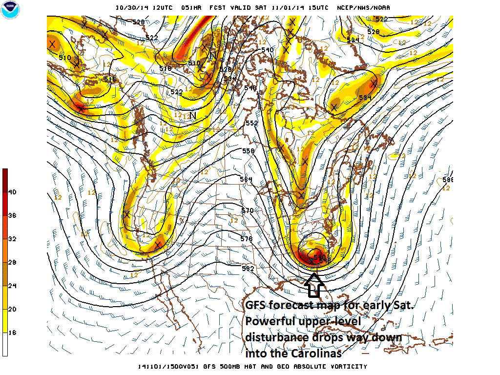
An unusually strong upper-level disturbance dropping southeastward from south-central Canada over the next couple of days will combine with Arctic air to help spawn a strong storm off the Mid-Atlantic coastline on Saturday. This series of events will generate snow this weekend for some higher elevation locations of the Mid-Atlantic region with significant accumulations possible in mountainous regions like eastern West Virginia, western Virginia, and western North Carolina. In addition, cold air will flood the I-95 corridor region from DC-to-Philly-to-NYC on Saturday night and Sunday riding in on increasingly strong winds as the storm intensifies off the coastline and ultimately begins a turn towards the northeast. The storm will probably be too far off the coast to produce heavy precipitation in the immediate I-95 corridor, but rain showers can occur at any time from late Friday night into early Saturday night and it is not out of the question that snowflakes mix in at times; especially, in higher elevation locations to the north and west Philly and DC.

Winds will be sustained at 20 to 30 mph up and down the east coast from Saturday night through Sunday with gusts to 40 mph possible at times. Coastal areas are likely to get buffeted by wind gusts over 50 mph on Saturday night and Sunday. Temperatures will likely flirt with the freezing mark on two occasions this weekend in the I-95 corridor: late Saturday night/early Sunday and – perhaps even more likely - late Sunday night/early Monday. Also, since the upper-level disturbance will drop so far to the south over the next couple of days from south-central Canada into the Carolinas (see GFS 500 millibar forecast map for Saturday morning), the cold air will plunge way down into the Southeast US and records could be broken this weekend from the Carolinas-to-Florida. There will be a gradual warm up in the Mid-Atlantic region during the first half of next week.

One final note...the weather looks dry and cool for Halloween trick-or-treating early tomorrow night as any rain showers in the area will likely hold off until later at night.

7:00 AM | Dry, cool weather through tomorrow evening; windy and chilly this weekend as a strong storm forms off the coast

Paul Dorian

6-Day Forecast

Today

Mostly sunny, noticeably cooler than yesterday, highs in the upper 50’s

Tonight

Partly cloudy, chilly, lows by morning in the low-to-mid 40’s

Friday

Partly sunny, cool, mid-to-upper 50’s

Friday Night

Becoming cloudy, chilly, rain showers possible late, mid-to-upper 40’s

Saturday

Cloudy, becoming windy and unseasonably chilly, rain showers likely, low 50's

Sunday

Partly sunny, windy, unseasonably cold, mid-to-upper 40’s

Monday

Mostly sunny, chilly, but a bit milder than Sunday, low-to-mid 50’s

Tuesday

Partly sunny, cool, near 60

Discussion

A cool front passed through the region yesterday and ushered in noticeably cooler air for today and tomorrow and an even colder air mass will arrive over the weekend. Following two dry and cool days to close out the work week, deep upper-level trof will set up early this weekend in the Northeast US and the result will be the development of a strong storm off the Mid-Atlantic coastline. Winds will increase later Saturday, temperatures will hold at below normal levels, and there will be some rain shower activity, but the steadiest, heaviest precipitation is likely to stay to our south and east as the storm intensifies off the coast. Cold pours into the I-95 corridor Saturday night once the off-shore low pressure system pulls to the northeast and temperatures on Sunday will hold in the 40's along with a stiff wind. A gradual warm up will take place in the Northeast US during the first half of next week.

Video

httpv://youtu.be/698LnTxOr7o

7:00 AM | *A major cold shot for the weekend; rain and even snow a threat for the Mid-Atlantic*

Paul Dorian

6-Day Forecast

Today

Mostly cloudy, not as warm as yesterday, a couple of showers are likely this afternoon, highs in the upper 60's

Tonight

Clouds early with a possible shower then becoming partly cloudy, turning cooler late, lows by morning in the mid-to-upper 40’s

Thursday

Mostly sunny, cooler, near 60

Thursday Night

Partly cloudy, chilly, low 40’s

Friday

Partly sunny, cool, mid-to-upper 50’s

Saturday

Considerable clouds, windy and unseasonably cold, rain showers likely that could even mix with snowflakes at times, mid 40’s

Sunday

Mostly sunny, breezy, still unseasonably cold, upper 40’s

Monday

Mostly sunny, not as chilly, low-to-mid 50’s

Discussion

A cool front is passing through the region today and there can be a couple of mid-day and afternoon showers associated with it and it’ll turn out a bit cooler than yesterday. Temperatures tomorrow and Friday behind the frontal system will be even cooler with the 50's likely for highs on both days. By Saturday, a deep upper-level trough of low pressure will set up in the northeastern US and the result will be a major shot of cold air into the Mid-Atlantic region along with increasingly strong winds. Low pressure will develop quickly near the coastline on Saturday and this system will produce some precipitation that should be mainly in the form of rain; however, there is the real threat that the rain mixes with or changes to snow in nearby higher elevation locations to the northwest and perhaps even into the big cities along I-95. Warmer weather does return to the region next week following the abnormally cold weekend.

Video

httpv://youtu.be/FV8ioACmU1c

7:00 AM | A surge in temperatures today, but a major cold shot for the weekend and snow is not out of the question in the metro region; Antares rocket launch postponed until early tonight

Paul Dorian

6-Day Forecast

Today

Mostly sunny, warmer, highs in the low-to-mid 70’s

Tonight

Increasing clouds, mild, chance for a shower or two late, lows near 60 degrees

Wednesday

Mostly cloudy, a bit cooler, a couple of showers possible, upper 60’s

Wednesday Night

Mostly cloudy, turning cooler late, mid-to-upper 40’s

Thursday

Mostly sunny, cool, near 60

Friday

Partly sunny, even cooler, mid-to-upper 50’s

Saturday

Considerable clouds, windy, unseasonably cold, rain and/or snow showers possible, mid-to-upper 40’s

Sunday

Mostly sunny, breezy, still unseasonably cold, upper 40’s

Discussion

There will be a surge in temperatures today ahead of an approaching cold front with highs well up in the 70’s up and down the I-95 corridor from DC-to-NYC. This warm up will be short-lived; however, as a cold frontal passage will begin a downward trend in temperatures for the second half of the week. A major cold shot will arrive on Saturday as deep upper-level troughing develops in the eastern US and this will lead to the formation of a storm near the Mid-Atlantic coastline. As a result, winds will howl on Saturday, high temperatures will be confined to way below normal levels in the 40's, and some precipitation is likely which can be in the form of snow in higher elevation locations just to the northwest of Route I-95 and perhaps even into the big cities from DC-to-NYC.

One other note, last night's Antares rocket launch at NASA/Wallops Island, VA was scrubbed due to a boat in the launch site area. The rescheduled time for the launch is 6:22PM early tonight. While clouds were not an issue last night in terms of viewing conditions around here, they will be a bit more of a concern early tonight. For more information on this go to http://vencoreweather.com/2014/10/27/930-am-rare-dual-space-event-early-tonight-1st-nighttime-launch-of-an-antares-rocket-at-645-pm-and-at-nearly-the-same-time-transit-of-the-international-space-station-both-should-be-visible-t/.

Video

httpv://youtu.be/ubKClmeHdBc

7:00 AM | *Major cold shot arrives for the weekend...snow showers likely in higher elevations to our northwest*

Paul Dorian

6-Day Forecast

Today

Mostly sunny, seasonably cool, highs in the low-to-mid 60’s

Tonight

Partly cloudy, cool, lows in the low 50’s

Tuesday

Mostly sunny, warmer, low-to-mid 70’s

Tuesday Night

Mostly cloudy, mild, chance for a shower, lows in the upper 50’s

Wednesday

Mostly cloudy, breezy, cooler, maybe a shower or two, mid-to-upper 60’s

Thursday

Mostly sunny, cool, upper 50’s

Friday

Partly sunny, cool, mid 50’s

Saturday

Partly sunny, windy, cold, upper 40’s

Discussion

High pressure will push into the area today and generate seasonably cool weather as we begin the new work week. Temperatures will surge on Tuesday ahead of another cold front, but we'll cool down again behind the frontal system for the second half of the week. A strong push of downright cold air for this time of year will arrive by the weekend and high temperatures on Saturday – the first day of November – will likely hold in the 40's around here which is way below normal and snow showers are likely in higher elevation locations just to our northwest.

Video

httpv://youtu.be/WCjk_grP63E

7:00 AM | An extended stretch of chilly weather begins on Sunday after a couple of nice days; next important rain threat comes by mid-week

Paul Dorian

6-Day Forecast

Today

Mostly sunny, pleasant, highs in the low 70’s

Tonight

Partly cloudy, cool, chance for a late shower, lows in the mid-to-upepr 50's

Saturday

Partly sunny, seasonably cool, becoming breezy later in the day with the chance for a shower, near 70

Saturday Night

Mostly cloudy, windy, maybe a shower, turning quite chilly late with lows in the mid-to-upper 40’s

Sunday

Mostly sunny, windy, quite cool, upper 50’s

Monday

Partly sunny, quite cool, upper 50’s

Tuesday

Mostly cloudy, quite cool, showers likely, near 60

Wednesday

Mostly cloudy, breezy, quite cool, showers likely, upper 50’s

Discussion

High pressure will push in today and generate nice weather around here as we end the work week and begin the weekend. Another strong cold front, however, will whip through the region tomorrow night and it’ll turn much cooler for an extended period of time beginning Sunday. High temperatures today and Saturday will not be far from the 70 degree mark, but should generally be confined to the 50’s on Sunday, Monday, Tuesday and Wednesday. The cold front will primarily pass through on the dry side tomorrow evening; however, a shower or two cannot be ruled out; especially, in the western suburbs and the breeze will kick up noticeably late tomorrow and it'll stay quite windy tomorrow night and Sunday. Low pressure will drop southeastward from the Great Lakes region into the Mid-Atlantic by Tuesday and it could then strengthen along the east coast at mid-week giving us the chance for some rain on both Tuesday and Wednesday along with continued cool conditions. Elsewhere, Gonzalo weakened a bit overnight, but it remains a major hurricane (category 3) this morning with sustained winds at 130 mph and it makes its closest approach to Bermuda today bringing with it hurricane-force winds for several hours and a strong storm surge.

Video

httpv://youtu.be/UJKY_MRjVmM

7:00 AM | Rain threat hangs on early today...big improvement waits until tomorrow and Saturday

Paul Dorian

6-Day Forecast

Today

Mostly cloudy, not as warm as the past couple of days, periods of rain winding down this morning, a residual afternoon shower or two possible, highs in the lower 70’s

Tonight

Mostly cloudy, turning cooler late, maybe an evening shower, upper 50’s towards morning

Friday

Mostly sunny, rather nice, low 70’s

Friday Night

Partly cloudy, cool, near 55 degrees for lows

Saturday

Mostly sunny, seasonably cool, becoming breezy, maybe a shower late, upper 60’s

Sunday

Mostly sunny, breezy, quite cool, upper 50’s

Monday

Mostly sunny, still quite cool, upper 50's

Tuesday

Partly sunny, quite cool, chance for showers late, upper 50’s

Discussion

The powerful cold front that generated heavy rain around here late yesterday and again last night will slowly pull away from the region to the northeast this morning, but it’ll stay somewhat unsettled through the afternoon as the upper-level low associated with the surface front passes nearby. Big improvement comes for tomorrow and Friday as high pressure returns to the region, but it turns quite cool beginning Sunday for an extended period of time following the passage of another cold front. High temperatures from Sunday through Tuesday of next week will likely be confined to the 50's in much of the I-95 corridor.

Elsewhere, on the tropical front, Gonzalo has reached major hurricane status (category 4) with sustained winds at 140 mph and is bearing down on Bermuda with a serious hit expected there on Friday. It is the first Atlantic hurricane to reach category 4 status since 2011 (Ophelia). Fortunately, the US mainland has not been hit by a major hurricane since the crazy year of 2005 - the longest stretch without a major hurricane in the US since at least the year 1900. In the Pacific Ocean, Tropical Storm Ana is likely to miss Hawaii to the south later this week.

Video

httpv://youtu.be/RnifxOne9j0

1:00 PM | **Heavy rain and embedded strong thunderstorms**

Paul Dorian

Discussion

An active cold frontal system supported by vigorous upper-level energy will generate heavy showers and potential strong thunderstorms in the I-95 corridor into early Thursday. Heavy rain on the order of 1-3 inches has the potential to create some localized flooding problems during the next 18 hours or so. The heaviest and steadiest rain will end by early tomorrow, but residual showers are possible later Thursday as the powerful upper-level low associated with this dynamic system passes nearby. High pressure will bring improvement to the Mid-Atlantic region as we close out the work week and begin the weekend with the return of some sunshine, but it'll turn noticeably cooler for Sunday and Monday.

7:00 AM | **Heavy rain event from early tonight into Thursday...heavy showers and potential strong thunderstorms associated with strong cold front and powerful upper-level energy**

Paul Dorian

6-Day Forecast

Today

Mostly cloudy, breezy, muggy, warm, showers and thunderstorms possible by the end of the day, highs in the mid-to-upper 70’s

Tonight

Heavy showers and embedded strong thunderstorms possible, some of the rain will be heavy at times, mild, lows near 65

Thursday

Showers continue and possibly a thunderstorm or two, some of the rain will be heavy at times, breezy and mild, mid 70’s

Thursday Night

Mostly cloudy, cooler late, slight chance for a shower, upper 50’s towards morning

Friday

Mostly sunny, pleasant, near 70

Saturday

Mostly sunny, seasonably cool, upper 60’s

Sunday

Mostly sunny, quite cool, near 60

Monday

Partly sunny, quite cool, near 60

Discussion

An active cold frontal system supported by vigorous upper-level energy will generate heavy showers and potential strong thunderstorms in the NYC metro region from late today into early Thursday. Heavy rain on the order 1-3 inches has the potential to create some localized flooding problems and scattered strong thunderstorms are possible during this upcoming heavy rain event. The heaviest and steadiest rain will end early tomorrow, but residual showers are possible Thursday afternoon as the upper-level low associated with this dynamic system passes nearby. High pressure will bring improvement to the Mid-Atlantic region as we close out the work week and begin the weekend with the return of some sunshine, but it'll turn noticeably cooler for Sunday and Monday.

7:00 AM | Much warmer today and Wednesday; heavy rain event late Wednesday into Thursday

Paul Dorian

6-Day Forecast

Today

Becoming partly sunny and turning much warmer, breezy, highs in the upper 70’s

Tonight

Mostly cloudy and mild, drizzle and patchy fog possible late, lows in the middle 60’s

Wednesday

Mostly cloudy, breezy, warm, showers and thunderstorms possible at the end of the day, mid-to-upper 70’s

Wednesday Night

Showers and thunderstorms likely, some of the rain will be heavy at times, mild, low 60’s

Thursday

Cloudy, not quite as warm, showers likely and possibly a thunderstorm, some of the rain will be heavy, near 70

Friday

Partly sunny, seasonably cool, near 70

Saturday

Mostly sunny, cool, mid-to-upper 60’s

Sunday

Mostly sunny, quite cool, low-to-mid 60’s

Discussion

A warm front passed through the region late yesterday and it’ll turn much warmer for today and Wednesday with some I-95 corridor spots flirting with the 80 degree mark for highs during both afternoons. An active cold frontal system supported by vigorous upper-level energy will generate a heavy rain event in the Mid-Atlantic region from later tomorrow into early Thursday. Heavy rain on the order of an inch to an inch and a half has the potential to create some localized flooding problems tomorrow night into early Thursday and strong thunderstorms are possible during this upcoming heavy rain event. Clearing will hold off until Friday at which time high pressure will build back into the region and bring improvement to close out the work week and begin the weekend.

Video

httpv://youtu.be/_q0Xlbl6VFo