Contact Us

Use the form on the right to contact us.

You can edit the text in this area, and change where the contact form on the right submits to, by entering edit mode using the modes on the bottom right. 


123 Street Avenue, City Town, 99999

(123) 555-6789

email@address.com


You can set your address, phone number, email and site description in the settings tab.
Link to read me page with more information.

backlit-stratus-clouds-2013-04-05.jpg

Blog

Weather forecasting and analysis, space and historic events, climate information

Filtering by Category: NYC

2:50 PM | Strong-to-severe thunderstorm threat for tonight

Paul Dorian
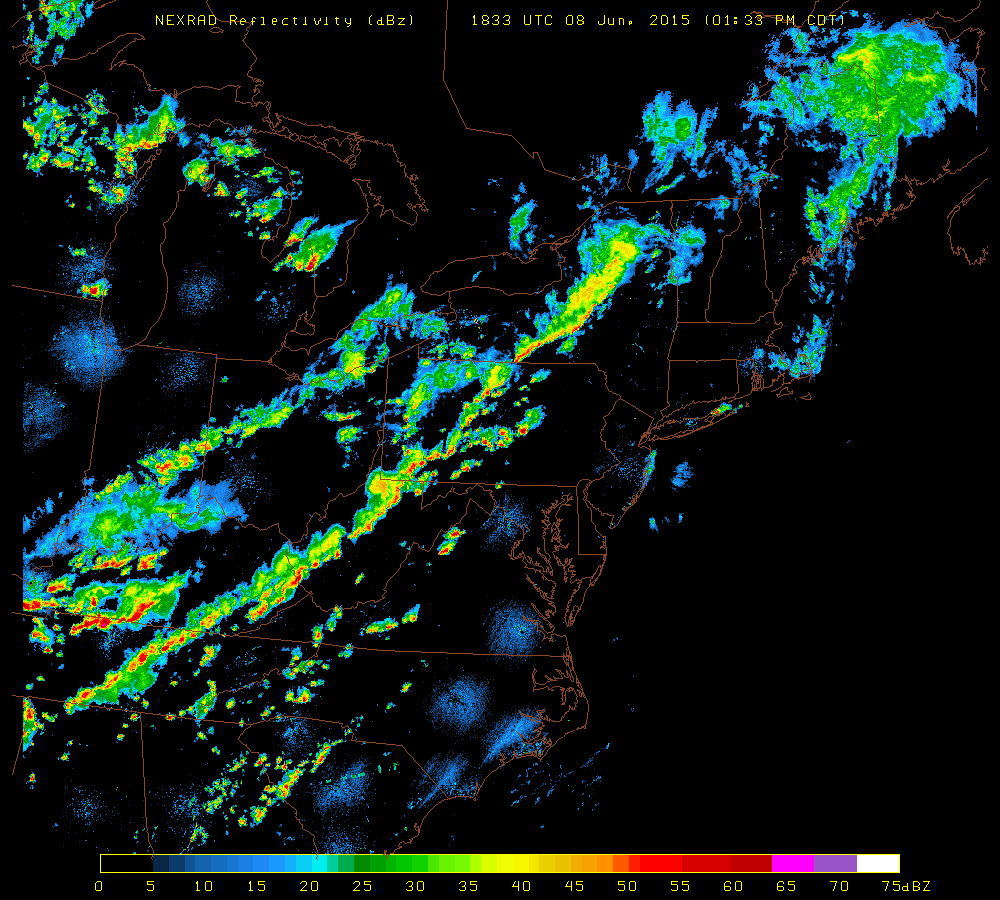
ne3comp[NEXRAD radar image at 2:33 PM; courtesy University of Wisconsin]

Discussion

The combination of an approaching cold front, building heat and humidity, and an upper-level wave of energy is sparking the formation of strong-to-severe thunderstorms in much of western portions of the Mid-Atlantic region. Latest radar (above) shows an impressive line of thunderstorms from central Pennsylvania to West Virginia in a pre-frontal trough of low pressure. Skies have partially cleared along the I-95 corridor from the morning low cloud deck and this has allowed for afternoon de-stabilization of the atmosphere with increasing low-level heating. The National Weather Service has not put out any watches or warnings for the immediate I-95 corridor; however, they have issued “tornado watches” for areas just to the west of the big cities. NWS “watches/warnings” are likely to be issued later today for the I-95 corridor from DC-to-Philly-to-NYC. Any thunderstorm this evening can contain damaging wind gusts, brief downpours, hail and perhaps even an isolated tornado with the expected timetable of ~6pm to midnight.

7:00 AM | Showers and thunderstorms later today and early tonight...some of the storms can reach strong-to-severe levels

Paul Dorian

6-Day NYC Forecast

Today

Clouds and limited sun, breezy, warm, a few showers north of the city this morning, showers and thunderstorms possible everywhere late, highs near 80 degrees

Tonight

Showers and thunderstorms likely, some of the thunderstorms that form can be on the strong-to-severe side with heavy rainfall and gusty winds, mild, lows not far from 65 degrees

Tuesday

Mainly cloudy, warm, still the chance for a shower or thunderstorm, low-to-mid 80’s

Tuesday Night

Chance for an early shower or thunderstorm then becoming partly cloudy, mild, mid 60’s

Wednesday

Mainly sunny, warm, low-to-mid 80’s

Thursday

Mainly sunny, warm, mid 80’s

Friday

Mainly sunny, warm, mid 80’s

Saturday

Partly sunny, warm, chance for showers and thunderstorms, low-to-mid 80’s

Discussion

A strong cool front will approach the region later today and tonight bringing with it a fresh round of showers and thunderstorms to the I-95 corridor. Some of the thunderstorms that form later today in the Mid-Atlantic region will be on the strong-to-severe side with heavy rainfall, gusty winds and possible hail. Improvement will follow the frontal passage by mid-week, but temperatures will reach very warm levels during the second half of the week with highs climbing well into the 80's each day.

Video

httpv://youtu.be/QbVhZcnUoys

7:00 AM | Weekend looking pretty decent after another cloudy, damp and cool day

Paul Dorian

6-Day NYC Forecast

Today

Mostly cloudy, still on the cool side with a spotty shower or two, highs in the upper 60’s

Tonight

Mostly cloudy, cool, slight chance for showers, lows not far from 60 degrees

Saturday

Partly sunny, a bit warmer, slight chance for a shower or thunderstorm, upper 70’s

Saturday Night

Partly cloudy, cool, mid-to-upper 50’s

Sunday

Mainly sunny, pleasant, low-to-mid 70’s

Monday

Mainly cloudy skies, warmer, a fresh round of showers and thunderstorm likely late, upper 70's

Tuesday

Partly sunny skies, still warm, chance for a shower or thunderstorm, near 80 degrees

Wednesday

Mainly sunny skies, warm, near 80 degrees

Discussion

All in all, the weekend is looking pretty decent…a cold front will cross the region early Saturday and it could set off a spotty shower or thunderstorm in the I-95 corridor on Saturday, but much of the day will be rain-free and Sunday looks especially nice with sunshine, comfortable temperatures and humidity levels. Another cold front will approach the region later Monday and it is likely to bring a fresh round of showers and thunderstorms to the region along with warmer conditions.

Video

httpv://youtu.be/kPWjYxq-iw0

7:00 AM | Weekend looking pretty nice

Paul Dorian

6-Day NYC Forecast

Today

Mainly cloudy, cool, slight chance for showers, highs in the lower 60’s

Tonight

Mostly cloudy, cool, chance for showers, lows in the upper 50’s

Friday

Mainly cloudy, still cool, cannot rule out a shower or thunderstorm, near 70 degrees

Friday Night

Mostly cloudy, cool, slight chance for showers, near 60 degrees

Saturday

Partly sunny skies, comfortable, cannot rule out a spotty shower or thunderstorm, mid-to-upper 70’s

Sunday

Mainly sunny skies, pleasant, low-to-mid 70’s

Monday

Mainly cloudy skies, a bit warmer, chance for another fresh round of showers and thunderstorms late, upper 70’s

Tuesday

Partly sunny skies, warm, chance for showers and thunderstorms, near 80 degrees

Discussion

A frontal system stalled to our south will keep us unsettled today and on the cool side of normal for this time of year. Another frontal system will cross the area Friday night into Saturday and then high pressure will build in for much of the weekend.

7:00 AM | Still on the cool side with some temporary clearing late

Paul Dorian

6-Day NYC Forecast

Today

Cloudy early, some clearing likely late, cool, highs in the upper 60’s

Tonight

Mostly cloudy, cool, lows in the middle 50’s

Thursday

Mostly cloudy, still cool with the chance for a few showers, mid 60's

Thursday Night

Mostly cloudy, cool, chance for showers, mid 50's

Friday

Mainly cloudy skies, a bit warmer, cannot rule out a few showers or even a thunderstorm, low-to-mid 70’s

Saturday

Partly sunny skies, warm, cannot rule out a shower or thunderstorm, mid-to-upper 70’s

Sunday

Partly sunny skies, not as warm, low 70’s

Monday

Mainly cloudy skies, a bit warmer, chance for showers and thunderstorms, mid 70’s

Discussion

High pressure will try to push into our region today from the north, but yesterday’s frontal system has stalled out rather close by. As a result, it’ll clear some this afternoon, but clouds should return overnight and Thursday can bring us a few more showers. Temperatures yesterday were held to unusually cool levels in the Northeast US by an ocean flow of air with Central Park's high at only 55 degrees - nearly 20 degrees below normal. Boston, MA had its coldest "2nd of June" ever with a high of only 49 degrees. Looking ahead, another frontal system will approach the region late Friday into Saturday and, while there can be a shower or thunderstorm on Saturday, the weekend should turn out to be pretty decent.

7:00 AM | Lingering showers today and quite cool...improvement comes for the second half of the week

Paul Dorian

6-Day NYC Forecast

Today

Occasional showers today and quite cool, highs in the upper 50’s

Tonight

Evening showers possible; otherwise, mostly cloudy skies, cool, lows in the low 50’s

Wednesday

Partly sunny, comfortably cool, upper 60's

Wednesday Night

Mostly cloudy, cool, low-to-mid 50’s

Thursday

Mainly cloudy skies, cool, cannot rule out a couple of showers, upper 60's

Friday

Mainly cloudy skies, a bit warmer, chance for showers, mid 70’s

Saturday

Mainly cloudy skies, warm, chance for showers and maybe a thunderstorm, near 80 degrees

Sunday

Partly sunny skies, not as warm, low 70’s

Discussion

The frontal system that is grudgingly pushing through the I-95 corridor will finally pull off the east coast by tonight. As a result, lingering showers are likely today and it'll stay unusually cool with a low-level ocean flow of air. While the second half of the week will be quieter than the beginning of the week, there will be enough instability in the atmosphere to generate a few showers each day as we head into the weekend or perhaps even a thunderstorm.

7:00 AM | *More heavy rain with possible flash flooding*

Paul Dorian

6-Day NYC Forecast

Today

Mostly cloudy, cooler with additional showers and thunderstorms, some of the rain will be heavy at times with possible flash flooding, highs in the upper 60’s

Tonight

Cloudy and cool with showers and thunderstorms likely, some of the rain will be heavy at times with possible flash flooding, lows in the upper 50’s

Tuesday

Periods of rain and possibly a thunderstorm mixed in, some of the rain will be heavy at times with possible flash flooding, mid-to-upper 60’s

Tuesday Night

Evening showers possible then late night clearing likely, cool, low-to-mid 50’s

Wednesday

Mainly sunny skies, comfortable, low 70’s

Thursday

Partly sunny skies, pleasant, cannot rule out a shower or thunderstorm, low-to-mid 70’s

Friday

Mostly cloudy skies, a bit warmer, chance for showers and thunderstorms, upper 70's

Saturday

Mostly cloudy skies, warm, chance for showers and thunderstorms, near 80 degrees

Discussion

Waves of low pressure are riding along a frontal boundary zone that is slowly working its way through our area. As a result, in the transition to a cooler weather pattern, showers and thunderstorms will continue into late Tuesday and some of the rain will be heavy at times with possible flash flooding. Most locations along the I-95 corridor from DC-to-Philly-to-NYC will see an additional 1.50 to 3.00 inches of rainfall in the next 24 hours or so on top of last night's soaking rains with localized amounts of 4+ inches possible. The second half of the work week will feature some improvement and pretty comfortable temperatures, but a shower or thunderstorm cannot be ruled on Thursday and Friday.

Video

httpv://youtu.be/L19kFFWwnkk

7:00 AM | Weekend showers and thunderstorms to usher in noticeable relief for early next week...some of the rain from Sunday into Monday can be heavy at times

Paul Dorian

6-Day NYC Forecast

Today

Mainly sunny skies, comfortably warm and less humid, highs not far from 80 degrees

Tonight

Partly cloudy skies, quite mild, lows in the mid-to-upper 60’s

Saturday

Partly sunny skies, warm and more humid, chance for showers and thunderstorms late in the day, low 80’s

Saturday Night

Showers and thunderstorms possible, mild, mid-to-upper 60’s

Sunday

Mostly cloudy skies, cooler, showers likely and possible thunderstorms, some of the rain can be heavy at times, low-to-mid 70’s

Monday

Mostly cloudy skies, noticeably cooler, showers likely, some of the rain can be heavy at times, low-to-mid 60’s

Tuesday

Mostly cloudy skies, still cool, chance for showers, mid-to-upper 60’s

Wednesday

Partly sunny skies, comfortable, low-to-mid 70’s

Discussion

High pressure will re-establish itself off the east coast today into Saturday and this will continue our warm weather pattern, but the humidity has dropped somewhat in the overnight hours. A strong cool front will move slowly across the area from Sunday into Monday bringing with it showers and thunderstorms and some of the rain can be heavy at times. Once this front clears the region, high pressure over southeastern Canada will promote an easterly flow of air in the Mid-Atlantic and it’ll turn much cooler as a result on Monday and Tuesday. In fact, temperatures are likely to be confined to the 60’s for highs on both of those days in much of the I-95 corridor.

Video

httpv://youtu.be/QhXtZK20bk8

7:00 AM | Shower and thunderstorm threat continues today...weekend showers and thunderstorms to bring much relief for early next week

Paul Dorian

6-Day NYC Forecast

Today

Partly sunny skies, quite warm and humid, still the chance for showers and thunderstorms, some of the storms can be on the strong side; especially, north of the immediate NYC region, highs in the low 80’s

Tonight

An evening shower or thunderstorm possible; otherwise, partly cloudy skies, quite mild, lows in the mid-to-upper 60’s

Friday

Mostly sunny skies, warm, low 80’s

Friday Night

Partly cloudy skies, mild, mid-to-upper 60’s

Saturday

Partly sunny skies, warm, low 80’s; chance for showers and thunderstorms at night

Sunday

Mostly cloudy skies, much cooler, chance for showers and thunderstorms, low-to-mid 70’s

Monday

Mostly cloudy skies, even cooler, chance for showers and thunderstorms, low-to-mid 60's

Tuesday

Mostly cloudy skies, cool, chance for showers, low-to-mid 60’s

Discussion

A weakening cool frontal system approached the region yesterday and it will stall out in the area today while continuing to dissipate. This frontal boundary zone - albeit on the weak side - will still generate enough instability in the atmosphere to continue the threat today for an afternoon or evening shower or thunderstorm and some of the storms can be on the strong side; especially, just to the north of NYC. Another frontal system - a much more significant cool front - will arrive late Saturday night/Sunday and with it will come a solid band of showers and thunderstorms. Following this weekend frontal passage, there will be much in the way of relief of this warmth and humidity for Sunday, Monday and Tuesday. In fact, temperatures should hold in the 60's for highs in many parts of the I-95 corridor on Monday and Tuesday as cool high pressure in southeastern Canada takes control.

12:55 PM | Strong-to-severe thunderstorm threat for later today along the I-95 corridor

Paul Dorian

radar.jpg

radar[Latest PA/MD radar image; courtesy NOAA, RadarScope]

Discussion

Latest radar (above) shows an impressive line of thunderstorms forming from central Pennsylvania to western Maryland in a pre-frontal trough of low pressure. Skies have partially cleared along the I-95 corridor from the morning low cloud deck and this will allow for afternoon de-stabilization of the atmosphere with increasing low-level heating. A high-resolution computer forecast model (HRRR, below) shows a pretty solid line of thunderstorms at 6pm this evening ranging from DC-to-Philly-to-NYC. Any thunderstorm this afternoon and early evening can contain damaging wind gusts and brief heavy downpours. There are currently no severe thunderstorm watches issued by the National Weather Service for the I-95 corridor, but that could very well change over the next couple of hours. The window of opportunity for any strong-to-severe thunderstorm activity is approximately 2 to 8pm.

HRRR_6pm [HRRR computer forecast model map for 6pm this evening; courtesy NOAA]