
12:10 PM | **Major snowstorm potential continues for late week**
Paul Dorian

Movement of the main upper-level feature crucial to the development of the storm (based on 12Z NAM forecasts)
Overview
Low pressure will pull out of the south-central states late this week and should reach the Mid-Atlantic coastline by Friday night or early Saturday strengthening all along the way to a powerful – and potentially news making - system by the weekend. The potential exists for a major snow event in the I-95 corridor in the Friday/Saturday time period, but there are still a few days to go and several details have to still be ironed out. The upper-level feature that will help to generate this potential powerful storm is still out over the Pacific Ocean and it won’t come ashore onto the US west coast until Tuesday night and then it should slide to the south-central states by Thursday night (500 millibar forecast maps from 12Z NAM). As a result, while the numerous computer forecast models are in general agreement on a big storm, high confidence will have to hold off until Wednesday or so as it won’t be until then that there is better data sampling over land of the all-important upper-level system that will play a crucial role. By the way, there is potential for another big storm by the middle or latter part of next week.
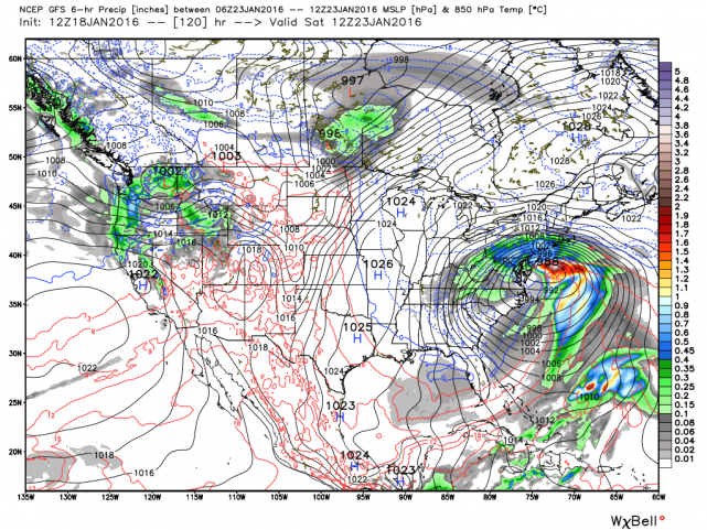
12Z GFS surface forecast map for Saturday morning; courtesy Weather Bell Analytics
Latest GFS forecast model
All systems are go from the latest GFS computer model run (12Z) as far as a major snowstorm is concerned for the I-95 corridor region from DC-to-Boston. Low pressure pulls out of the Tennessee Valley on Friday and intensifies explosively at the Mid-Atlantic coastline by Saturday. The 12Z GFS surface map for Saturday morning shows the major storm near the Mid-Atlantic coast with a tight pressure gradient (as represented by the black lines) between the surface low pressure system and "banana-shaped" high pressure to the north and northwest. This tight pressure gradient suggests winds could become a serious issue and there will be a full moon on Saturday which won’t help the situation as far as tides are concerned at coastal areas. The "banana-shaped" high pressure to the north and northwest is a crucial ingredient for Mid-Atlantic snowstorms as it helps to sustain cold air in the region. The total snowfall map from the latest run of the GFS forecast model shows a “bullseye” of accumulating snow in the region from DC to Philly.

12Z GFS total accumulated snowfall map by Sunday morning; courtesy Weather Bell Analytics
Details still to be ironed out
The rain/snow line is often an issue with Mid-Atlantic snowstorms and it appears rain can become a part of this storm in coastal sections of NJ and the Delmarva Peninsula - and perhaps even close to the immediate I-95 corridor. However, even in those areas, significant accumulating snow is possible. The latest Canadian forecast model is slightly warmer than the GFS and it has mixing as an issue even into the immediate I-95 corridor – along with significant accumulating snow.
Another detail to be ironed out is the timing of the arrival of the precipitation. Currently, snow could arrive in the DC region during Friday morning and then into Philly during the afternoon hours – but too early here for anything definite.

12Z Canadian surface forecast map for early Friday afternoon (blue=snow, green=rain, pink=mix)
Stay tuned.
Meteorologist Paul Dorian
Vencore, Inc.