
11:45 AM Friday | *****The "Blizzard of 2016" - an increase in accumulations in some areas*****
Paul Dorian

Suomi NPP VIIRS view rfom space of the "Blizzard of 2016" from 0723 UTC (1:23 am CST). Note the lightning streaks in the cold front that extends south over the Gulf of Mexico. Note also clouds streaming out over the Atlantic Ocean due to very cold air in place where the storm is headed and expected to produce heavy snow, ice and high winds. Lights can be seen in many cities across the eastern U.S.; image courtesy CIMSS-University of Wisconsin
The "Blizzard of 2016" will go down as one of the all-time great snowstorms in the Mid-Atlantic region and total snowfall accumulations may be historic over a wide area. It continues to look like this storm will be a paralyzing, high-impact and long-lasting storm for the DC, Philly and NYC metro regions that will include significant snow accumulations, some serious blowing and drifting, possible power outages, and perhaps even some thunder snow and lightning. The zone of heaviest snowfall now appears that it will extend from the DC metro region to across the entire Philly metro region, interior New Jersey, and to the southern side of the NYC metro region.
Latest accumulation estimates are as follows (and some totals have increased based on recent observations, latest computer model info, etc.):
DC area - 20-30 inches (with higher amounts possible in spots),
Philly area - 18-25 inches (with higher amounts possible in spots),
NYC area - 10-20+ inches (Note- these 20+ inch estimates are for just to the south of the city and that kind of accumulation could certainly end up shifting northward to throughout the NYC metro region)
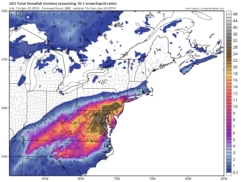
12Z GFS total snowfall map; courtesy tropicaltidbits.com
The snow arrives in DC between noon and 2pm, Philly area between 5 and 7pm and NYC between 9pm and 21am. There is a chance for some mixing with sleet at times in the I-95 corridor, but this should primarily be a snow event for the big cities and points to the north and west. There can be some mixing in with rain or sleet at times or even a temporary changeover to rain and/or sleet across New Jersey and the Delmarva Peninsula during this storm, but even there significant snow accumulations will take place (6-12" at the immediate coastline of southern New Jersey, 15-25 inches across interior locations across NJ and the Delmarva). Temperatures should generally be confined to the 20’s during the storm.
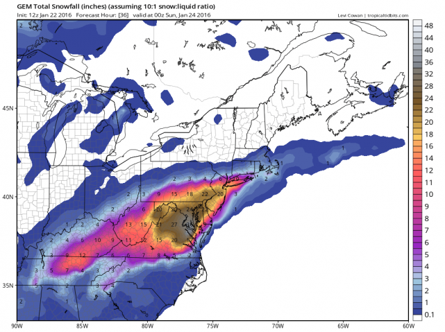
12Z Canadian total snowfall map; courtesy tropicaltidbits.com
The snow is likely to come down at varying rates later tonight and on Saturday as small-scale or “mesoscale” banding is likely to set up given the impressive dynamics involved with this unfolding system. Specifically, the snow can fall heavily at times with blizzard conditions and can also slacken off to “little or nothing” at times as well if a "dry slot" develops. There may be a sharp drop off in snow accumulation amounts on the northern edge of the storm’s precipitation field across upstate PA and northern New Jersey.
In addition to the significant snowfall, problems at coastal locations will include flooding and beach erosion given the expected long-lasting period of strong NE winds (plus Saturday’s full moon). Wind gusts could reach 70 mph at coastal locations by later tomorrow and 50 mph at inland areas including along I-95. A storm surge of 4 to 5 feet can be expected at the Delaware coastline, and 3 to 4 feet in southern New Jersey. Also, given the expected long-period of strong winds at and near the coast and the mixture of snow, sleet and rain, more widespread power outages are a real concern along and just inland of the coastline.
One final note - computer forecast models should approach more common solutions as the event time approaches and, indeed, today's GFS, NAM and Canadian forecast models have converged on a pretty similar outcome as far as total snow accumulations are concerned (see three maps).

12Z Canadian total snowfall map; courtesy tropicatidbits.com
Meteorologist Paul Dorian
Vencore, Inc.