
11:20 AM | **Coastal storm to produce snow accumulations in much of the region late tonight/early Friday...next threat continues for Monday night/Tuesday**
Paul Dorian

GOES 13 morning visible satellite image; courtesy NASA
Overview
An active weather pattern with multiple storm threats is setting up in the Mid-Atlantic region for the next couple of weeks and it will be a challenging time for weather forecasting. The first storm to affect the region is rapidly evolving and it will affect the region from late tonight into early Friday. This storm will produce snow accumulations across much of the region and it will very likely have an impact on the Friday morning commute. Another snow threat comes next week - most likely in the Monday night/Tuesday time frame - and this one could be even more significant than tonight's system possibly affecting the entire I-95 corridor from the Mid-Atlantic to New England.
Details
A cold front slid through the region earlier today and it will stall out just off the east coast later today in a north-to-south orientation. The latest satellite image shows an extensive cloud band associated with the frontal system and it has an impressive influx of moisture from the southern Gulf of Mexico to New England. Low pressure will ride up along that frontal boundary zone later tonight and early tomorrow and it looks like it will throw some snow back into the immediate I-95 corridor and points eastward to the coastline. The precipitation could begin as rain later tonight; especially, near coastal sections of New Jersey and in the Delmarva Peninsula, but the rain will change to snow and accumulations are likely in many areas. The snow will have trouble sticking at first given the current boundary layer conditions, but it shouldn't take too long for it to stick considering it'll be dark and the flakes could be on the big (heavy, wet) side. This snowfall can unfortunately have an impact on the Friday AM commute, but not on this evening’s rush hour as it should arrive around or after midnight. This coastal storm is likely to turn into a more significant snow event up the coastline from Providence, RI to Boston, MA. The next snow threat most likely comes in the Monday night/Tuesday time frame.
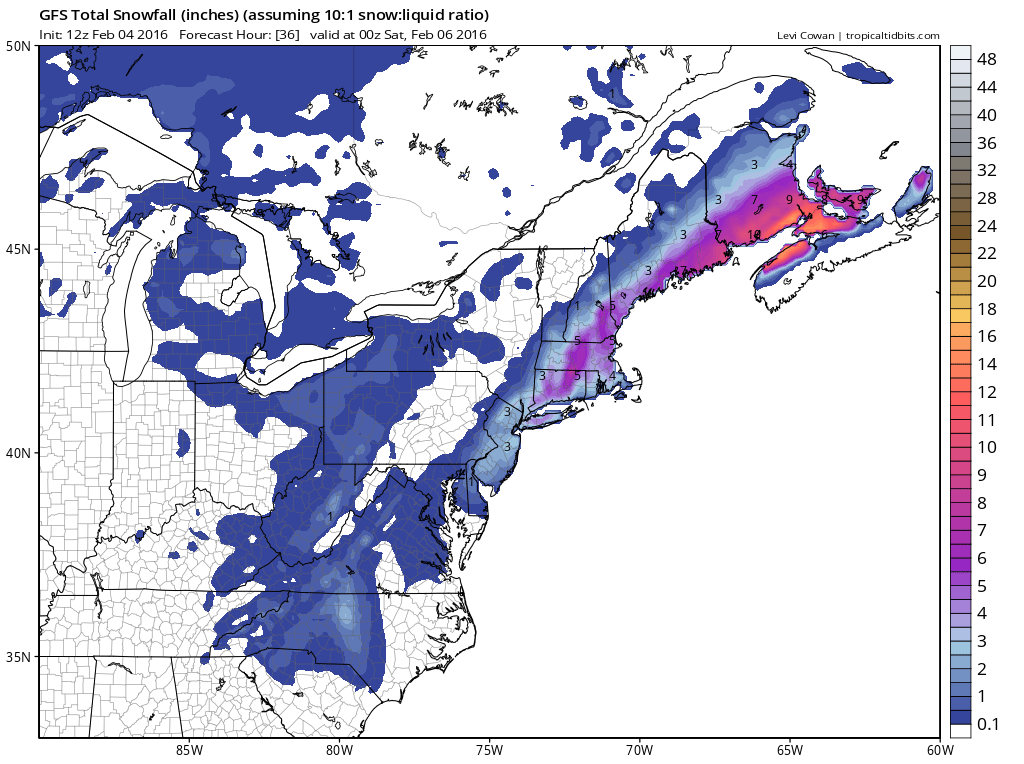
12Z GFS snowfall map for upcoming system (late tonight/early Friday); courtesy tropicaltidbits.com, NOAA
Here are some preliminary snowfall estimates in the Mid-Atlantic region for the period of late tonight into early Friday:
DC metro region: dusting to an inch or two (highest amounts likely on the eastern side of the District)
Philly metro region: dusting to 3 inches (best chance of highest amounts in eastern sections closest to NJ state line such as southern Bucks County)
NYC metro region: 2-5 inches (4-7 inches Long Island)
Interior and coastal NJ, Delmarva Peninsula: 3-6 inches
Meteorologist Paul Dorian
Vencore, Inc.