1:55 PM | *Coastal storm threat late Sunday into Monday*
Paul Dorian
Overview
Tomorrow will likely be the mildest day of the week with high temperatures well up in the 60’s in much of the I-95 corridor – perhaps even 70+ degrees in the DC metro region – but then a couple of cold fronts will create a downward trend in temperatures around here late in the week and this weekend. One cold front arrives on Thursday in the Mid-Atlantic region and this will be followed by a secondary push of colder air late Friday. By the early part of the weekend, building high pressure to our north will usher in progressively colder air and then attention will shift to the east coast at the end of the weekend for the potential of a coastal storm.

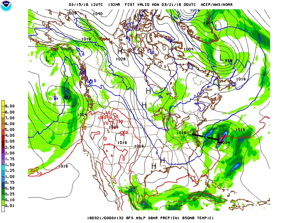
12Z GFS forecast map for Sunday evening with low pressure well off the coast, but an inverted trough of low pressure that extends back into the Mid-Atlantic region; courtesy NOAA
Coastal storm threat
There are signs for a storm to form near the Mid-Atlantic coastline late Sunday or early Monday and it could be cold enough for this potential storm to produce snow in the Northeast US. There are still several days to go before this possible event and many different solutions are on the table. One possible solution is that a storm develops on Sunday and takes an inland track producing only rain in the I-95 corridor and points to the east. Another possibility is that any storm that forms late in the weekend stays far enough out-to-sea to produce only a minimal impact on the I-95 corridor or even nothing at all. Finally, there is the chance that a strong storm forms near the Mid-Atlantic coastline and this particular scenario could result in some snow for the immediate I-95 corridor and points to the north and west of there back to the Appalachian Mountains.

12Z Canadian forecast map for early Monday with intense low pressure near the Mid-Atlantic coastline; map courtesy tropicaltidbits.com
Signals from NAO and AO indices
The solution for an inland type of storm late in the weekend is probably the least likely given the signs coming from the North Atlantic Oscillation (NAO) and Arctic Oscillation (AO) indices. Both of these are forecasted to drop into negative territory (below) over the next few days and that generally favors a coastal storm track as opposed to the inland runner. Indeed, negative NAO and AO indices this time of year generally favor a colder solution in the I-95 corridor with cold air farther to the south and east (i.e., towards the coastline) compared to an inland runner scenario.

Trending of AO and NAO indices from positive to negative territory over the next few days; courtesy NOAA
Model forecasts
The 12Z GFS model forecast for Sunday evening (above) suggests there will be a storm, but it would be well off the east coast. However, there are clues that this is not a clear cut solution by the GFS as it does hold onto moisture in the Mid-Atlantic region (green) despite the far east look to its current storm track prediction. In addition, this model run depicts an inverted trough of low pressure extending from the surface low center well off the coast to the Mid-Atlantic region (as indicated by the black line). This trough suggests to me that the ultimate forecast may show low pressure closer to the coastline than currently depicted by the GFS model. In other words, the GFS is likely to correct to the west and closer to the coast with the surface low pressure system as we get closer to event time. Meanwhile, the 12Z Canadian forecast model already has an intense coastal storm near the Mid-Atlantic coastline as of Monday morning (above) throwing snow back into the DC metro region (as indicated by blue). Also, last night’s 00Z European ensemble forecast map for Sunday evening (below) has low pressure relatively close to the Mid-Atlantic coastline.

00Z Euro ensemble forecast map for Sunday evening; map courtesy tropicaltidbits.com
Meteorologist Paul Dorian
Vencore, Inc.