11:25 AM | **The real “March Madness”…accumulating snow a possibility in DC, Philly, NYC as spring begins**
Paul Dorian
00Z Euro "ensemble" run with multiple solutions on low pressure location as of Sunday night; courtesy Weather Bell Analytics
Overview
A cold front will arrive later today with scattered showers and thunderstorms and its passage will send high temperatures down some ten degrees or so between this afternoon and tomorrow afternoon. An even more important and stronger cold front will push through the region late Friday and this frontal passage will usher in noticeably colder (Arctic) air for the weekend as cold high pressure builds to our north. By early Sunday, attention will shift to the east coast as it is quite likely that a strong storm will form near the Mid-Atlantic coastline and - given the cold air that will be in place - there is a possibility for accumulating snow in the DC-to-Philly-to-NYC corridor with several inches on the table.
00Z UKMET model forecast map for Sunday night with "tucked" in low pressure near the Mid-Atlantic coastline
Coastal storm threat
Signs continue to point to a storm forming near the Mid-Atlantic coastline on Sunday and it could be just cold enough for this potential storm to produce significant accumulating snow in the I-95 corridor. There are still a few days to go before this possible event and different storm tracks are still on the table. One possible storm track would keep the storm far enough off the coast to prevent anything significant in the I-95 corridor. Another storm track would keep the storm near the Mid-Atlantic coastline as it intensifies and pulls slowly to the northeast. This second “closer to the coast” scenario is increasingly likely and it could put the I-95 corridor in the “sweet spot” for accumulating snow on Sunday and Sunday night although rain can still mix in at times; especially, to the south and east of I-95. One last possible storm track would take this storm and push it well inland which would likely produce only rain in the I-95 corridor. The signals from the now slightly negative NAO index argue against an inland track and this scenario is rapidly fading from feasibility as the event time approaches.
09Z SREF forecast map for Sunday afternoon with low pressure location in orange; courtesy NOAA
Computer forecast models
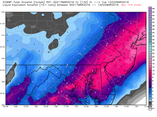
The recent runs of the European computer forecast model have been the most bullish in terms of snowfall (see snow map below) for the I-95 corridor from this potential late weekend coastal storm. The 00Z Euro model run favors a storm track near the Mid-Atlantic coastline which would indeed put the I-95 corridor in the “sweet spot” for accumulating snow. The Euro model intensifies the storm rapidly on Sunday just off the Mid-Atlantic coastline and pushes it to the northeast so that by the time Monday morning rolls around, there is forecasted to be a very powerful storm sitting near eastern Maine. The 00Z European “ensemble” run from last night (top) displays multiple scenarios and it “clusters” most low pressure systems near the Mid-Atlantic coastline which supports the Euro “operational” model idea of a “close to the coast” storm track and potential significant snowfall in the I-95 corridor. The 00Z UKMET computer forecast model (above) also supports the idea of a “tucked in” coastal low as does the most recent 09Z Short-Range Ensemble Forecast (SREF) model run (depicts the low pressure location in orange right near the Mid-Atlantic coastline). The 12Z GFS model run produces a nice hit of accumulating snow in the I-95 corridor (below), but not as bullish as last night's Euro model run.
00Z Euro (operational model run) snowfall forecast map for upcoming storm; courtesy Weather Bell Analytics
Stay tuned- the first day of spring could be quite exciting around here.
Meteorologist Paul Dorian
Vencore, Inc.
12Z GFS total snowfall map for upcoming storm; map courtesy tropicaltidbits.com


