1:30 PM | *Strong-to-severe thunderstorm threat here later today…tornado outbreak possible across the central Plains*
Paul Dorian
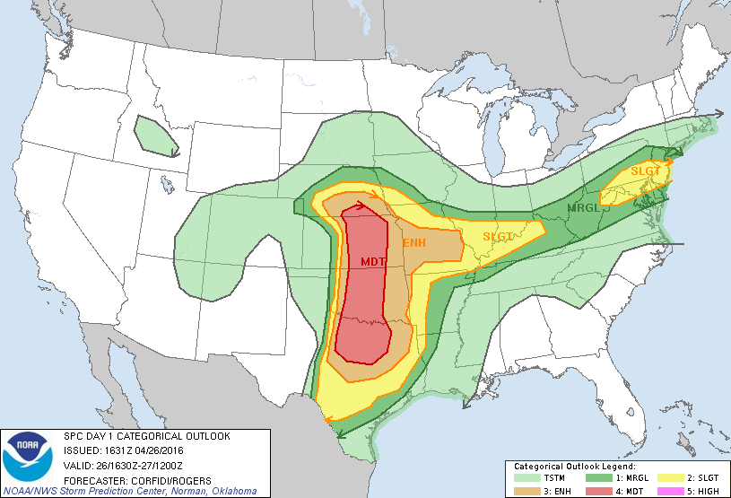
Categorical outlook for severe weather according to NOAA's Storm Prediction Center (SPC) in Norman, Oklahoma
Overview
It is nearly May and yet snow is falling today across much of Northern New England and also across portions of the Rockies and western US. These two unusually cold air masses associated with the snow are contributing to increasing atmospheric instability in the Mid-Atlantic region and the central Plains as they clash with neighboring warm, humid air. As a result, scattered strong-to-severe thunderstorms are likely in the DC-to-Philly-to-DC corridor later this afternoon and evening, and a more serious severe weather outbreak is possible from Texas to Nebraska with several tornadoes possible across the U.S. heartland.
GOES visible image reveals clearing skies across much of the Mid-Atlantic region following morning clouds which will help to destabilize the atmosphere; image courtesy Penn State eWall, NOAA
Mid-Atlantic region
There is a strong cold front dropping southward through the Mid-Atlantic and its boundary zone is separating relatively cold air to the north and warm, humid air to the south. The “frontogenesis” map (below) indicates that the main frontal boundary zone which separates the cold and warm air masses extends in an east-west fashion from Ohio to New Jersey. Temperatures are currently at least 20 degrees cooler from Northern New Jersey to Southern New Jersey and that same type of temperature difference exists between the northern and southern halves of Pennsylvania and Ohio. Adding to the unfolding destabilization of the atmosphere are the clearing skies as seen on the latest visible satellite image (above). The resultant warming in the lower atmosphere will destabilize the atmosphere this afternoon from DC-to-Philly-to-NYC as temperatures soar through the 70's. As this east-west frontal boundary zone drops slowly southward, scattered strong-to-severe thunderstorms will form in the DC-to-Philly-to-NYC corridor during the mid-afternoon and evening hours (~3PM to 9PM). Any strong-to-severe thunderstorm later today can contain brief heavy downpours, damaging winds, and small hail. The weather will quiet down around here late tonight and Wednesday, but more instability returns later this week.
Red lines indicate "frontogenesis" values, black line depicts boundary zone separating cold air to the north and warm, humid air to the south; courtesy NOAA
Central Plains severe weather and tornado threat
A deep upper-level low currently sits over the central Rockies along with an unusually cold air mass and this may contribute to a significant severe weather event later today and through much of tonight in the central Plains. Up until now, tornadoes have been running at below normal levels for this stage of the spring season, but they’ll likely rise some later today and then perhaps again late in the week as another outbreak is possible. The main zone of concern for today’s severe weather outbreak extends from Nebraska to Texas with a focus on central and eastern Oklahoma and central and eastern Kansas. Any severe thunderstorm in this region later today can contain heavy downpours, damaging winds, large hail and can spawn tornadoes.
Stay tuned in both parts of the country for updates later today and tonight.
Meteorologist Paul Dorian
Vencore, Inc.


