12:30 PM | Cooler conditions likely for Memorial Day following first stretch of summer-like weather
Paul Dorian
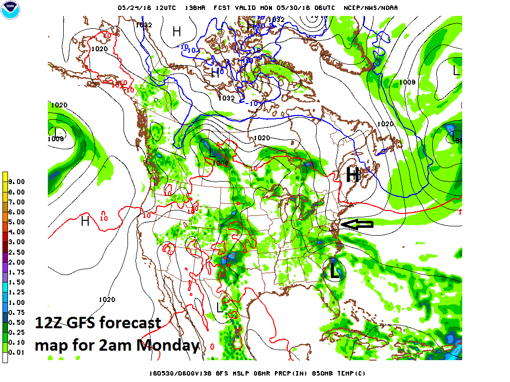
12Z GFS forecast map for early Monday (Memorial Day) with strong high pressure over northern New England, strengthening easterly flow into the DC-to-Philly-to-NYC corridor, and low pressure with tropical moisture near the Southeast US coastline; map courtesy NOAA
Overview
In our part of the world, cold frontal systems generally move in from the west passing through places like Chicago and Pittsburgh before they arrive here in the Mid-Atlantic region. However, there are occasions in which a cold front can slide through the Mid-Atlantic region by moving in a southwesterly direction down the Northeast US coastline; especially, during the late winter and spring season. These types of fronts are commonly referred to as “back door” cold fronts as they “sneak” in from the northeast as opposed to the usual “front door” type cold fronts that move in from the west. This time of year a “back door” cold front can make a huge difference in temperatures - suddenly replacing a very warm air mass with a chilly, damp flow of air. These fronts are characterized by a high pressure system to the north that can result in a wind shift to an easterly or northeasterly direction which around here is right off the ocean and the current sea surface temperatures are in the still chilly 50’s off of the New Jersey coastline.
Details on back door cold front and potential tropical system
There is a good chance that a backdoor cold front will “sneak” down the coast late this holiday weekend following the first real stretch of summer-like weather in the I-95 corridor that will begin in earnest on Wednesday. Temperatures tomorrow will soar to the 80’s and highs will remain well up in the 80’s for the last two days of the work week and right into the upcoming holiday weekend. In addition, humidity will become more noticeable as the week progresses and all of this will feel very different compared to what we’ve experienced during the bulk of the month of May.
By Sunday, high pressure will begin to build across southeastern Canada and that is the first sign that a back door cold front may be in the cards for the Northeast US. By Monday, strong high pressure will push into Northern New England and the clockwise flow around the high will generate E-NE low-level winds in the I-95 corridor region from DC-to-Philly-to-NYC. As a result, temperatures could drop noticeably by Monday (or even later Sunday) from the summer-like conditions expected earlier in the weekend – all following the passage of the dreaded back door cold front.
One final note, there will be low pressure with tropical moisture near the Southeast US coastline by early Monday and it could play an important role in our weather early next week. At a minimum, this low pressure system will help to tighten the pressure gradient in the Mid-Atlantic region and, in turn, strengthen easterly winds. There is an outside chance that this low pressure system becomes the second named storm of the 2016 Atlantic Basin tropical season (Alex was actually the first named system and formed during the month of January).
Meteorologist Paul Dorian
Vencore, Inc.

