12:00 PM | *Severe weather threat this afternoon in parts of the Mid-Atlantic and again on Thursday*
Paul Dorian
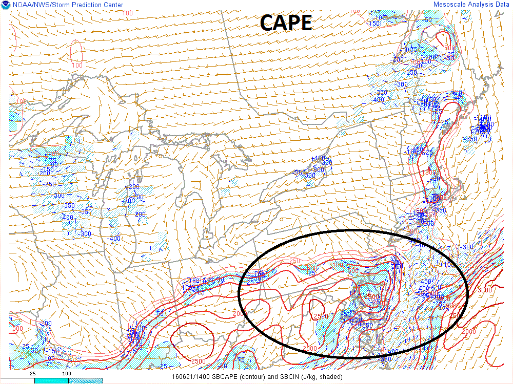
Surface-based Convective Available Potential Index (CAPE) shows instability in the southern Mid-Atlantic region; map courtesy NOAA/Storm Prediction Center
Overview
An active weather pattern over the next few days will bring two shots of strong-to-severe thunderstorm activity to the Mid-Atlantic region with damaging wind gusts, hail and even isolated tornadoes on the table. The first shot comes this afternoon and early evening primarily to the southern half of the Mid-Atlantic with the DC and Baltimore metro regions especially vulnerable as a cold front arrives from the northwest. A second opportunity will come on Thursday and this one looks even more impressive and is likely to be more widespread as a vigorous low pressure system and its associated cold front heads to the local area from the Ohio Valley. The good news is that all of this activity will quiet down at the end of the week as high pressure builds into the Mid-Atlantic and it looks like we are in store for another nice weekend.
Surface-based Lifted Index (LI) shows instability in the southern Mid-Atlantic; map courtesy NOAA/Storm Prediction Center
This afternoon
A cold front currently stretches from New England to Pennsylvania and the air mass is quite unstable in the southern half of the Mid-Atlantic region from far southern Pennsylvania southward to the DC metro region and eastward to southern New Jersey. This is the region that has the highest chance for strong-to-severe thunderstorm activity this afternoon whereas places farther north such as the NYC metro region have much lower probabilities. Surface-based stability indices such as the Convective Available Potential Energy (CAPE) and Lifted Index (LI) give us a pretty good idea as to where the most instability currently exists and it is generally in the region from far southern Pennsylvania southward to the DC metro region and eastward to southern New Jersey. Atmospheric instability increases as CAPE values go up and as LI values go down. CAPE values of 2500+ can be seen stretching from DC to southern NJ and the most negative LI values (-5) stretch across the same general region. A high-resolution computer forecast model suggests the afternoon activity will be scattered in nature with one batch to the northwest of DC early in the afternoon (below, left) and then scattered storms across the southern Mid-Atlantic late in the day (below, right).
High-resolution (HRRR) computer forecast model simulated radar maps for early this afternoon (left) and late this afternoon (right); maps courtesy Weather Bell Analytics, NOAA
Thursday
Activity on Thursday promises to be more widespread than today and there is the potential for some heavy rainfall and strong-to-severe thunderstorms throughout the Mid-Atlantic region from DC-to-Philly-to-NYC. Low pressure will trek across Pennsylvania from the Great Lakes region along with a trailing cold front. At the same time, hot air will be pressing northeastward into the Ohio Valley and the combination may produce a large mesoscale convective system (MCS) over Ohio, West Virginia and/or southwestern PA early in the day. If this does occur, then new development may occur later in the day in the “outflow boundary” region of this MCS and that would be the area to watch for potential late day storms in our region. Strong winds in the upper atmosphere on Thursday combined with strong convergence near the surface low pressure may be supportive of damaging wind gusts and hail.
12Z GFS forecast map for Thursday evening; map courtesy tropicaltidbits, NOAA
Meteorologist Paul Dorian
Vencore, Inc.


