1:00 PM | *Showers and thunderstorms later today into tonight...some of the storms can be strong-to-severe...another interesting event early next week*
Paul Dorian
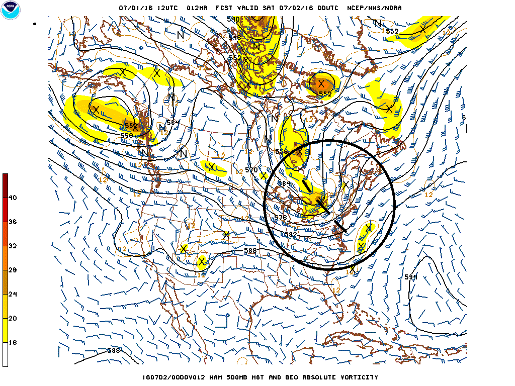
12Z NAM 500 mb forecast map for early tonight with "negatively tilted" upper-level short wave (circled region); map courtesy NOAA
Overview (Friday, July 1, 2016)
The combination of an impressive upper-level short wave, a strong surface cold front, an increasingly moist southerly flow of air, and some low-level heating will help to generate showers and thunderstorms later today into tonight for the region from DC-to-Philly-to-NYC. Some of the thunderstorms that form will likely reach strong-to-severe levels with potential damaging wind gusts, downpours, hail and even isolated tornadoes. Then, after a couple of nice weekend days with noticeably lower humidity, interesting weather could return early next week. A warm front will approach from the Ohio Valley on Monday and showers and thunderstorms are likely to return to at least portions of the Mid-Atlantic region and this could turn into a significant rain event; especially, near and south of the PA/MD border.
Moisture transport in lower levels of the atmosphere with south/southwest flow along the coast; map courtesy NOAA
Event #1 (This afternoon/Early Tonight)
A strong upper-level wave of energy now swinging eastward across the eastern Great Lakes will enhance upward motion around here later today as it becomes “negatively tilted” (above). Low-level heating will combine with this enhanced upward motion to destabilize the atmosphere as the afternoon progresses and showers and thunderstorms are likely to arrive in the usual summertime time frame of mid afternoon to late evening (i.e., 3pm to midnight). The cold front involved with today’s event will slide off the east coast on Saturday and that’ll set the stage for nice weather on Saturday and Sunday with comfortable conditions and plenty of sunshine.
Event #2 (Later Monday into Tuesday)
A warm front will form over the Ohio valley on Sunday and bring some heavy rainfall by early Monday to places that don’t need the rain (e.g. West Virginia). This area of rain along the warm frontal boundary zone will likely slide eastward on Monday, July 4th, and showers and thunderstorms could actually break out in the DC metro region during the afternoon hours. There is also the chance that these showers and thunderstorms reach the Philly and NYC metro regions later Monday into Tuesday, but those chances are a little less certain than in those areas along and south of the PA/MD border. The potential does exist for significant rainfall in the southern Mid-Atlantic from this next weather event including the DC metro region on Independence Day.
Potential heat second half of next week
Looking farther ahead, hot weather could arrive in the I-95 corridor by the middle of next week with high temperatures approaching the 90 degree mark. In fact, there is a chance that by the end of next week and weekend (9th, 10th), temperatures could be climbing well up into the 90’s.
June results
In general, June turned out to be slightly warmer-than-normal and drier-than-normal in the I-95 corridor. Temperatures ended the month at +0.9° in Philly, +0.8° in NYC (Central Park) and +1.0° at DCA (Reagan National Airport). Rainfall was below-normal as follows: Philly -1.56”, NYC -1.81”, DCA -0.10”. The normal high temperatures as we begin July are as follows: PHL 86°, NYC 83° and DCA 88°.
Meteorologist Paul Dorian
Vencore, Inc.


