10:50 AM | *Drenching rain to break the back of the current hot spell*
Paul Dorian
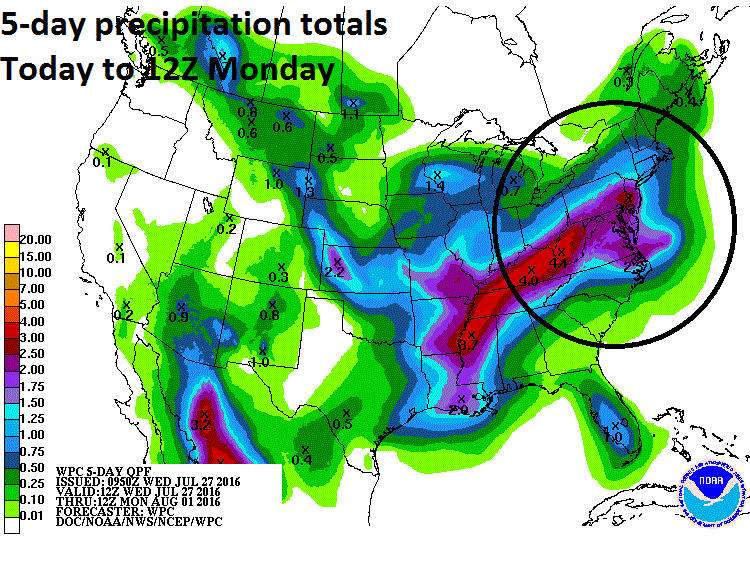
5-day precipitation totals between today and 8AM Monday; courtesy NOAA
Overview
Today is another hot day in the Mid-Atlantic region and tomorrow should feature high temperatures at or above the 90 degree mark, but a storm system pushing in from the Deep South at the end of the work week is likely to bring soaking rainfall to the area and it will help to break the back of this current heat wave. This low pressure system is likely to produce showers and thunderstorms in the local region from late tomorrow night into the day on Friday with heavy rain possible at times and some of the thunderstorms can be on the strong side. In addition, this type of unsettled weather pattern featuring a stalled out frontal boundary zone might just lead to a repeat performance over the weekend with more soaking rainfall possible associated with a second low pressure system. The strong likelihood for copious amount of clouds and occasional rainfall at the end of the work week and upcoming weekend will help to contribute to a noticeable reduction in temperatures so that highs are quite likely to be confined to the 80’s in coming days.
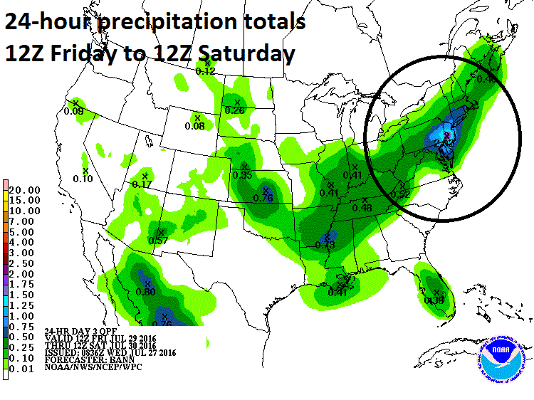
24-hour precipitation totals between 8AM Friday and 8AM Saturday; courtesy NOAA
Details
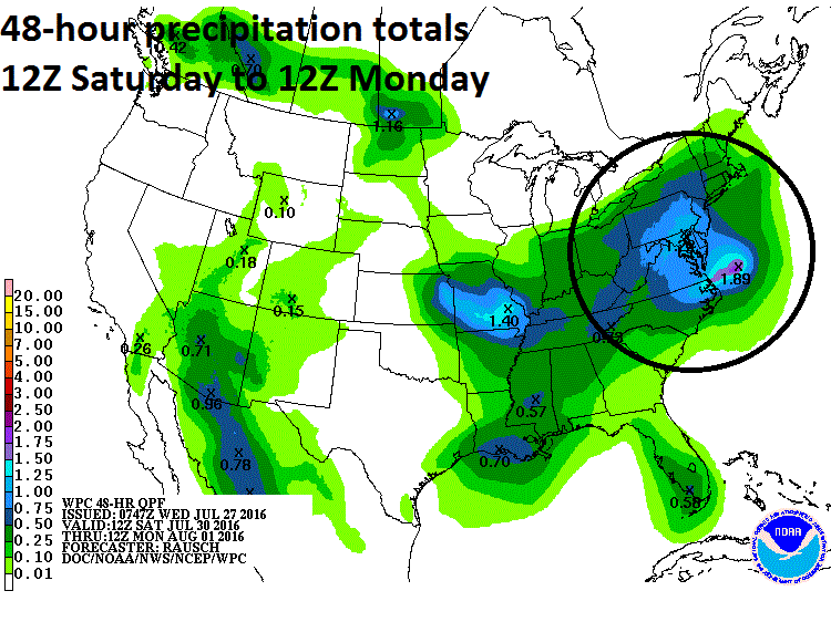
More than three inches of rain can fall in portions of the Mid-Atlantic region over the next five days as multiple low pressure systems ride along a stalled out frontal boundary zone from the Deep South into this area. Precipitable water amounts will be quite high at the end of the work week and during the weekend with abundant moisture ready to be squeezed out of the atmosphere. The first low pressure system to affect us with showers and thunderstorms will likely arrive later tomorrow night and continue into Friday. Some of the rain with this system could be heavy at times and there can be strong thunderstorms.
High temperatures on Thursday ahead of the storm system are likely to reach 90 degrees or slightly above, but this could turn out to be the last 90 degree day until sometime later next week as highs are likely to be confined to the mid and upper 80’s on Friday, Saturday and Sunday and even right through the early part of next week. NOAA forecasters "precipitation totals" are shown for 24 hours (early Friday to early Saturday), 48 hours (early Saturday to early Monday), and the 5-day period from today into Monday - I think they have a good handle on the overall situation. Stay tuned on this outlook as the exact timing and track of each individual impulse of low pressure is somewhat difficult to predict and this will impact the timetable for the bursts of heaviest rainfall.
48-hour precipitation totals from 8AM Saturday and 8AM Monday; courtesy NOAA
Meteorologist Paul Dorian
Vencore, Inc.


