11:15 AM | **Torrential rain and possible strong-to-severe thunderstorms on the way**
Paul Dorian
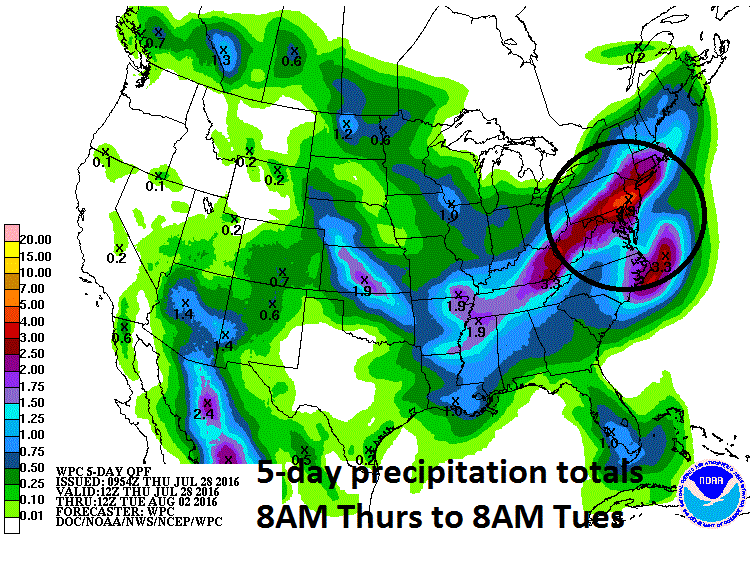
NOAA's 5-day precipitation totals from today until 8AM Tuesday; courtesy NOAA
Overview
Today will be the last for awhile in which high temperatures can reach the 90 degree mark as an important pattern change is about to take place in the Mid-Atlantic region and the result will be torrential rainfall and possible strong-to-severe thunderstorms. A storm system will push towards the Mid-Atlantic coastline over the next 12-24 hours with rain and slow-moving thunderstorms pushing in later today and continuing into early Friday. Some of the rain will be heavy at times from this low pressure system and some of the thunderstorms can reach strong-to-severe levels with gusty winds, flash flooding potential even isolated tornadoes.
On top of that, this type of weather pattern featuring a stalled out frontal boundary zone might just lead to a repeat performance over the weekend with more soaking rainfall possible associated with a second low pressure system - perhaps Saturday night into Sunday. The strong likelihood for copious amount of clouds and occasional rainfall over the next several days will help to contribute to a reduction in high temperatures so that they will be confined to the 80’s from tomorrow into next the middle of next week.
12Z 4-km NAM forecast map for 8PM Thursday; courtesy tropicaltidbits.com, NOAA
Details
As much as four inches of rain can fall in parts of the Mid-Atlantic region over the next five days as multiple low pressure systems ride along a stalled out frontal boundary zone from the Deep South into this area. Precipitable water amounts are quite high in the atmosphere and any lifting motion generated by low pressure systems over the next few days will be able to “squeeze out” abundant moisture that can lead to some serious flooding problems. The 12Z high-resolution (4-km) NAM model run shows low pressure over southern Virginia by 8pm this evening and it reaches the Mid-Atlantic coastline during the wee hours of the morning. Rain and possible thunderstorms could break out any time this afternoon and are very likely tonight into early Friday with torrential downpours and possible strong-to-severe thunderstorms. The rain is likely to slacken off or even completely end on Friday afternoon - but this won't be the end of the wet weather.
12Z 4-km NAM forecast map for 2AM Friday; courtesy tropicaltidbits.com, NOAA
High temperatures ahead of the storm system today could top out near 90 degrees - but it’ll be a struggle given the abundance in cloudiness - and they will have very little chance to climb that high tomorrow, this weekend, and early next week. NOAA’s precipitation totals for the next 5 days shows some spots accumulating more than 4 inches of rain in the Mid-Atlantic region and I believe that is quite likely - and perhaps even an underestimate. Stay tuned on this very wet outlook as the timing of each individual impulse of low pressure is difficult and this will impact the timetable for the bursts of heaviest rainfall.
Meteorologist Paul Dorian
Vencore, Inc.


