12:30 PM | ***Hermine approaching Florida Panhandle and makes landfall tonight…potential major impact later this weekend on Mid-Atlantic coastline***
Paul Dorian
Close-up satellite view of Hermine with the possible formation of an "eye" now underway; courtesy NOAA
Latest info on Hermine
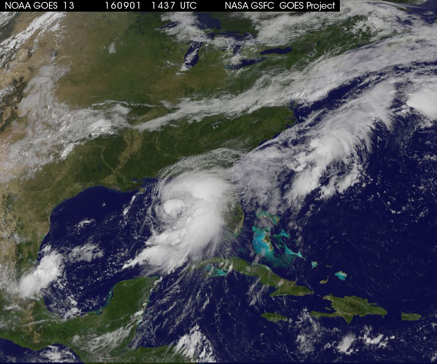
Hermine has become better organized this morning and could very well reach hurricane status by the time it makes landfall tonight in the Florida Panhandle region (just east of Apalachicola). If indeed it makes landfall as a hurricane, it would end an unprecedented hurricane drought for Florida where they haven’t seen a hurricane of any intensity since Wilma struck in October 2005 (3965 days ago). The latest movement is estimated to be north-northeast at around 12 knots with maximum sustained winds at 65 mph. Its central pressure has dropped significantly in the last several hours down to 29.27 inches. The latest satellite image of Hermine is quite impressive with the more familiar circular pattern setting up with respect to the clouds and convection and an “eye” is trying to form – not good news for Florida.
NOAA/NHC track and cone; my hand-drawn track in black; courtesy NOAA
Short-term Outlook
Hermine will generally move to the northeast after tonight’s landfall likely as a hurricane across northern Florida and then into southeastern Georgia by early tomorrow. At that point, Hermine will continue to the northeast along the South and North Carolina coastlines to a position not far from the Outer Banks of NC by early Saturday morning. On Saturday, Hermine will become embedded within a frontal boundary zone so whether it is still officially referred to as a “tropical” system at this time or it becomes considered “extra tropical” is up in the air and that is a NOAA/National Hurricane Center (NHC) decision. From a sensible weather standpoint, it doesn’t matter at all whether it is referred to as a major nor'easter later this weekend or a hurricane (and it could be that strong) as its potential significant impact on the Mid-Atlantic coastline will remain the same.
Sea surface temperatures are quite warm just off the Mid-Atlantic coastline; map courtesy Weather Bell Analytics
Mid-Atlantic concern
Once Hermine pushes off the northeastern coastline of NC, it’ll start to become under the influence of strong high pressure building across the Northeast U.S. As a result, its direction and movement will likely undergo an important change and this is where big problems may result for the Mid-Atlantic coastline from Virginia to New Jersey. (I have hand-drawn the potential path of Hermine - in my opinion - on top of NOAA’s official storm track and cone of probability). Hermine is likely to turn more to the north and slow-down in its movement during the Sunday/Monday time frame. This action would result in a real pounding along the coastline from Virginia to New Jersey and there is even a chance that it loops or backs into an inland position later in the weekend somewhere in this region.
00Z Euro forecast maps for Sunday PM (left) and Monday PM (right) showing very little movement; courtesy tropicaltidbits.com
In general, more rain and wind is likely closer to the coast and less inland; nonetheless, significant rain and wind is definitely still on the table for the immediate I-95 corridor in the late Saturday to early Monday time period. Coastal flooding is a serious threat given the potential slow-down of this system which would allow for a long period of strong northeast winds - and allow for the water to pile up. Hurricane-force winds are indeed on the table for coastal sections on Sunday from Virginia to New Jersey. Very warm sea surface temperatures off the Mid-Atlantic coastline will play a role in maintaining or even increasing the intensity of this storm once it reaches this general region.
12Z GFS forecast map for early Sunday afternoon; courtesy tropicaltidbits.com
Computer model forecasts
Overnight runs of the European computer forecast model featured a powerful storm sitting off the Mid-Atlantic coastline by Sunday PM that moves very little by Monday PM and this slow-down is the reason for serious concern along coastal regions. The latest 12Z (12-km) NAM computer forecast model features a stalling out powerful system just off the Virginia coastline come Sunday morning with rain and wind back into the I-95 corridor. The 12Z GFS also has rain and wind back to the I-95 corridor and also suggests there are big concerns for coastal sections of NJ, Delmarva and VA in terms of persistent strong winds and the prospects for coastal flooding.
Big picture satellite view of Hermine; courtesy NOAA, NASA
All eyes in the Mid-Atlantic region should continue to closely monitor this system over the next couple of days; especially, along the coastline.
Stay tuned.
Meteorologist Paul Dorian
Vencore, Inc.


