2:25 PM | **Wall of cold to head into central and eastern US later next week**
Paul Dorian
12Z GFS Ensemble (GEFS) forecast maps of 850 mb temperature anomalies in 6-hour increments from next Tuesday, December 5th, until Friday, December 15th; maps courtesy tropicaltidbits.com, NOAA/EMC
Overview
If you still have to put up outside Christmas lights and rake some more leaves then this weekend may be the last chance with seasonal temperatures in the Mid-Atlantic region. There are continuing strong signs for a major pattern shift in the central and eastern half of the nation that will bring some serious and sustained cold thanks to a combination of strong high-latitude blocking centered over Greenland, an intensifying upper-level trough in the central and eastern US, and strong high-pressure ridging along the west coasts of the US and Canada. The transition time period from the current mild weather pattern to this upcoming cold pattern looks like it will come around next Wednesday, December 6th with the arrival of a strong cold frontal system in the eastern states that will be followed by a wall of cold.
Discussion
Extremely cold air has been building up on the other side of the North Pole during the past few days and some of this Arctic air may push into the central and eastern US in a week or so. Siberia can be an important cold air source for the central and eastern US during the winter season and they have experienced temperatures more than sixty degrees below zero this week in that part of the world - more typical of late January rather than late November. For example, a low temperature of minus 69 degrees (F) was recorded early Tuesday in Delyankir, Russia and this actually is colder than the all-time record lows in every U.S. state except Utah (-69 degrees), Montana (-70 degrees) and Alaska (-80 degrees).
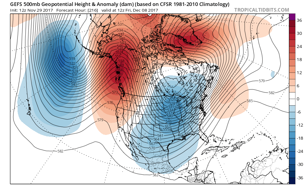
12Z GFS Ensemble (GEFS) forecast map of 500 mb height anomalies for next Friday, December 8th, with strong high-pressure ridging (orange) along the west coasts of US and Canada and also across northern latitudes and deep upper-level troughing (blue) over the central and eastern US; courtesy tropicaltidbits.com, NOAA/EMC
Across the US, the next several days will feature above-normal heights and a zonal flow of air (west-to-east) which will keep it anywhere from above-normal to near normal for much of the nation. Higher-than-normal pressure has existed during the past few days near Greenland where temperatures have been well above normal, but this high pressure area will tend to weaken this weekend before re-intensifying early next week. Also, strong ridging will extend westward into western Canada and down the west coast of the US by the middle and latter parts of next week. At the same time, upper-level troughing will intensify over the central US by the middle of next week and then it’ll expand into the eastern US.
As a result, temperatures are likely to start off on the mild side in the Mid-Atlantic region for the first half of next week – ahead of the strong cold front – but then they should drop sharply by the time Thursday rolls around. Once the cold air becomes established in the central and eastern US, it looks like it will be quite sustained due in large part to the blocking pattern unfolding across northern latitudes.
As far as snow is concerned, the initial blast of cold air is likely to generate some snow for the Great Lakes and Ohio Valley during the middle part of next week, but the Mid-Atlantic may have to wait until the following weekend for the threat of some snow. There are signs that a wave of energy may swing around the base of the expected upper-level trough at the end of next week and this could result in a coastal storm by early in the weekend (i.e., around Saturday, December 9th).
Stay tuned.
Meteorologist Paul Dorian
Vencore, Inc.
vencoreweather.com


