
12:05 PM *Still monitoring the threat for accumulating snow late Wednesday night/early Thursday morning*
Paul Dorian

12Z GFS surface forecast map for late Wednesday night; map courtesy tropicaltidbits.com, NOAA/EMC
The weather pattern will be very active in the I-95 corridor over the next few days ranging wildly from rain and high temperatures in the 60’s to the potential for some accumulating snow. It’ll turn much warmer on Tuesday and Wednesday in the DC-to-Philly-to-NYC corridor and the warm up will be accompanied by some rainfall. Colder air will then push into the region late Wednesday night and early Thursday and this temperature transition may result in a period of rain changing to accumulating snow. The greatest chance for accumulating snow late Wednesday night and early Thursday in the I-95 corridor will be in the northern and western suburbs and likely to the north of the Pennsylvania/Maryland border.

00Z Euro EPS snowfall accumulation map for the next five days
Models are coming into general agreement on the formation of low pressure along a cold frontal boundary zone by late Wednesday and this system is likely to move fairly quickly to a position just off the Mid-Atlantic coastline by early Thursday morning. Upper-level energy will drop into the middle of the country by mid-week and this should be the catalyst for the formation of low pressure in the eastern states just at the same time colder air pushes in from the northwest after an unusually warm couple of days. Precipitation from this developing low pressure system is likely to arrive in the I-95 corridor during the Wednesday late evening hours - likely in the form of rain - but as colder air works its way into the area a changeover to snow is possible; especially, to the north and west of the big cities and north of the Mason-Dixon Line.
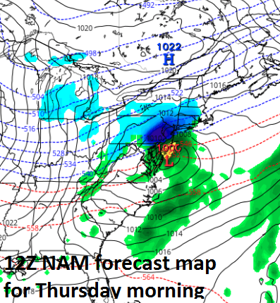
12Z NAM surface forecast map for early Thursday morning; map courtesy tropicaltidbits.com, NOAA/EMC
As the storm reaches the relatively warm waters just off the New Jersey coastline early Thursday morning, there could be a brief “sweet zone” time period where it is just cold enough for snow and the precipitation is falling quite heavily (i.e., as accumulating snow). The 12Z NAM shows this “sweet zone” possibility in its latest forecast map for early Thursday morning with heavy snow shown (in dark blue) across much of eastern PA, northern NJ and southeastern NY. Just a word of caution on the NAM computer forecast model; however, in my experience, it is generally more reliable within about 48 hours of event time. Nonetheless, this 72-hour forecast map by the 12Z NAM raises a red flag about the potential for this storm system.
Last night’s Euro ensemble model run also indicated the strong likelihood for accumulating snow in the Mid-Atlantic region during the five day period which encompasses this storm threat. The 12Z GFS features low pressure off the Mid-Atlantic coastline late Wednesday night (1am) with a changeover to snow (blue) seen in areas to the northwest of Philly and NYC, but plain rain (green) throughout the DC metro region at this particular time. The cold air that arrives in full force on Thursday will stick around into the weekend, but then – as has often been the case this winter – temperatures are likely to rebound once again.
Stay tuned, lots of details still to iron out.
Meteorologist Paul Dorian
Vencore, Inc.
vencoreweather.com
Video discussion on the upcoming storm threat: