12:15 PM | *”Clipper” system to feature three different phases with accumulating snow for parts of the Mid-Atlantic region on front and back ends*
Paul Dorian
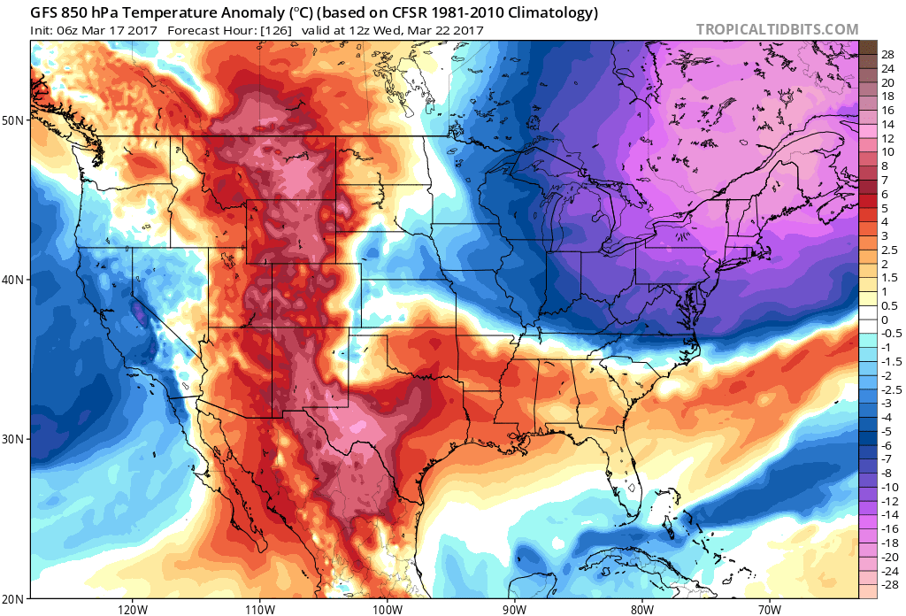
Another significant cold air outbreak arrives by the middle of next week in the Northeast US; map courtesy tropicaltidbits.com, NOAA/EMC (06Z GFS)
Overview
The next system to deal with in the Mid-Atlantic region will be a “clipper” system that drops southeastward from the Great Lakes later today and tonight. This system will feature three different phases that will produce a variety of weather conditions in the Mid-Atlantic region including the threat for accumulating snow on the front and back ends; primarily, in areas north of the PA/MD border. After another cold day on Sunday following the “clipper” system, it’ll turn milder early next, but then another major cold air outbreak arrives at mid-week with significantly below-normal temperatures.
Warm frontal phase (1) of "clipper" system; map courtesy tropicaltidbits, NOAA/EMC (12Z NAM)
“Clipper”
A “clipper” can be defined as a fast-moving system with limited moisture content that drops southeastward from southwestern Canada into the Northern Plains and then across the Great Lakes and ultimately, these systems can produce accumulating snow in the I-95 corridor when they reach the east coast. Our next system to deal with around here will indeed be a “clipper” low pressure system that will cross the Great Lakes region by early tomorrow and then reform off the Mid-Atlantic coastline on Saturday night. There will be three different phases of precipitation associated with this system that can be summarized as follows:
1) an initial burst of “warm air advection” late tonight associated with a warm frontal system
2) “warm sector” spotty and light precipitation on Saturday while in a slightly milder air mass and
3) precipitation associated with rapid intensification of the “clipper” low pressure system over the western Atlantic on Saturday night as colder air gets drawn in from the north and this is perhaps the most volatile phase.
Warm sector phase (2) of "clipper" system; map courtesy tropicaltidbits, NOAA/EMC (12Z NAM)
The first phase of precipitation late tonight associated with a warm frontal system is likely to be primarily in the form of rain south of the PA/MD border although snow and/or sleet can mix in at times and primarily in the form of snow in the Philly and NYC metro regions although rain and/or sleet can mix in at times. Small snow accumulations are possible late tonight and early Saturday during this phase (1) across the Philly and NYC metro regions on the order of a coating to an inch or so. On Saturday, any snow or mixed precipitation that remains early in the day is likely to change to all plain rain for the mid-day and afternoon hours as it turns somewhat milder following the passage of the warm front. The precipitation during this phase (2) will be rather light and spotty and there will be precipitation-free times throughout the day.
Intensification phase (3) of "clipper" system; map courtesy tropicaltidbits, NOAA/EMC (12Z NAM)
By Saturday night, the intensification phase (3) of the “clipper” low pressure system will take place off the Mid-Atlantic coastline and colder air will be drawn in from the north. As a result, any rain or mixed precipitation early in the evening is likely to change to all snow later tomorrow night – perhaps even a period of steady snow - and additional accumulations are likely across the Philly and NYC metro regions. Specifically, in the Philly metro region, there can be another coating to an inch or two later tomorrow night into early Sunday morning and 1-3 inches is likely in and around New York City with an outside chance at as much as 4 inches in some areas (e.g., Long Island). Snow showers may very well extend all the way south into the northern sections of the DC metro region, but little or no accumulation is expected there. Snow should come to an end by the early-to-mid-morning hours on Sunday along the I-95 corridor.
Another significant cold air outbreak
In addition to the threat for more accumulating snow in parts of the Mid-Atlantic region, there will be another significant cold air outbreak that arrives by the middle of next week. Temperatures will modify some on Monday afternoon and Tuesday will also be relatively mild, but another Arctic blast will arrive by mid-week and we’ll return to well below normal levels for this time of year on Wednesday and Thursday. There are signs, however, that this next cold blast will give way to noticeably milder conditions at the end of next week.
Meteorologist Paul Dorian
Vencore, Inc.
vencoreweather.com
Today's video discussion:


