12:20 PM | **Major storm to bring heavy rain and possible strong thunderstorms to the I-95 corridor**
Paul Dorian
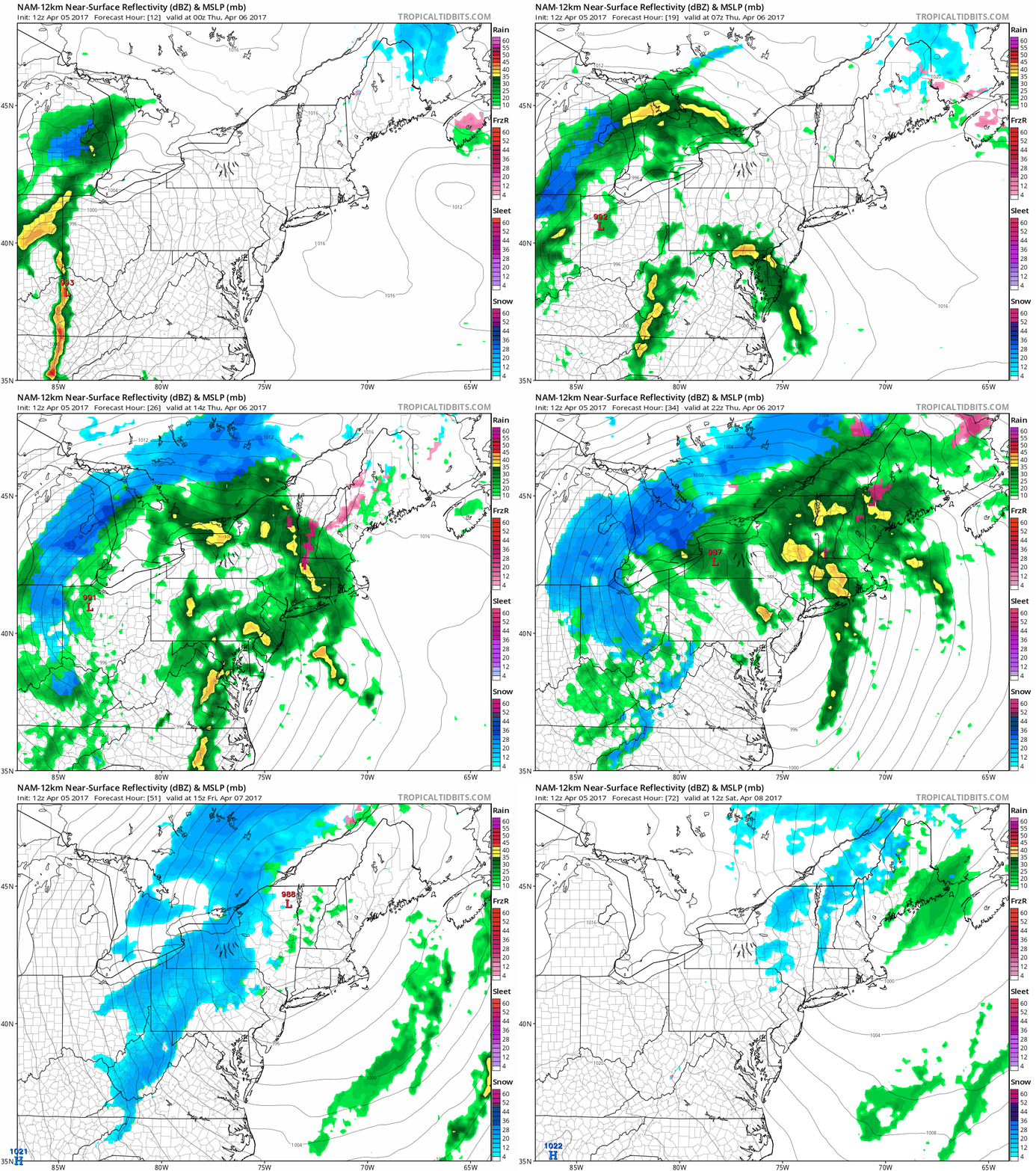
12Z NAM loop of forecasted precipitation maps from this evening until early Saturday; maps courtesy tropicaltidbits.com, NOAA/EMC
Overview
The active weather pattern that we have been experiencing during the past several days has one more potent system to send our way and it looks like it’ll be a major storm with some heavy rain and possible strong thunderstorms in the Mid-Atlantic region. Low pressure will form early tomorrow just east of the mountains in northern Virginia and then intensify rapidly as it pushes northward through Pennsylvania and into western New York. Aiding in the development of this powerful low pressure system and possible severe weather outbreak will be a combination of strong upper-level energy and energetic jet streaks at multiple levels of the atmosphere. The main severe weather threat area today is in the Southeast US with a focus on Georgia and South Carolina, but that'll transfer to the Mid-Atlantic on Thursday; especially, in those sections near the coastline.
On the backside of the storm, it’ll turn much cooler and windy on Friday with additional rain showers likely in the I-95 corridor region from DC-to-Philly-to-NYC. In addition, this major storm will likely generate accumulating snow on Friday in the Ohio Valley, Great Lakes, and the higher elevations of the Appalachian Mountains. One final note, grounds are now pretty well saturated in areas north of the PA/MD border after recent soaking rain events and this will raise concerns for localized flooding on Thursday and Thursday night.
Severe weather threat shifts from the Southeast US today (left) to the Mid-Atlantic region on Thursday (right); forecast maps courtesy NOAA/SPC
Details
Ingredients are coming together for a major storm to develop in the Mid-Atlantic region on Thursday and it may be accompanied by strong-to-severe thunderstorm activity. After an initial surface low pressure system dissipates over the Ohio Valley, a second low pressure area will form early tomorrow just on the east side of the Appalachians and then intensify as it treks from around northern Virginia through Pennsylvania and into New York State. In the upper atmosphere, there will strong jet streaks and a strong wave of energy that will take on a negative tilt (i.e., oriented from northwest-to-southeast) and this will generate strong upward motion in the eastern Mid-Atlantic region from mid-morning to early afternoon. This setup will likely support some heavy downpours and the potential of strong-to-severe thunderstorms with the most volatile time period likely from mid-morning to early afternoon in the I-95 corridor. The total rainfall amounts from this unfolding powerhouse storm system will likely increase to the northeast in the I-95 corridor with around 0.50-1.00 inches in DC, 1.0-1.5 inches in Philly, and 1.5-2.0 inches in NYC. Localized flooding is a concern in PA, NJ, and NY as a result of the expected heavy rainfall on top of already saturated grounds (not quite as saturated south of the PA/MD border).
12Z NAM forecast map for early tomorrow afternoon showing deep upper-level energy in the Mid-Atlantic region; map courtesy tropicaltidbits.com, NOAA/EMC
On the backside of the storm, much cooler air will push into the Mid-Atlantic region on Friday and winds will be quite strong out of the west-to-northwest. There are likely to be occasional rain showers on Friday in the I-95 corridor and accumulating snow is going to occur in the Ohio Valley, Great Lakes region, and Appalachian Mountains. It’ll stay cool and breezy on Saturday around here, but calmer and noticeably warmer conditions will return for Sunday, Monday and Tuesday as we’ll finally get a nice break in the action.
Meteorologist Paul Dorian
Vencore, Inc.
vencoreweather.com


