12:05 PM | *Cooler-than-normal pattern likely to return heading into the Memorial Day weekend*
Paul Dorian

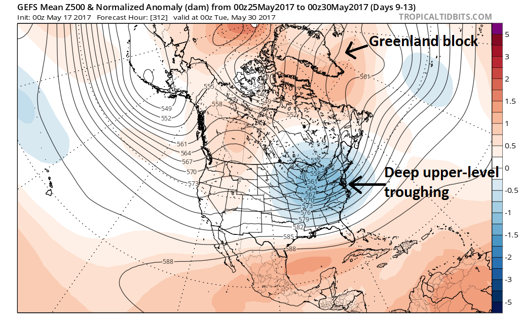
00Z GEFS forecast map of 5-day average 500 mb height anomalies for the period of May 25th to May 30th; map courtesy tropicaltidbits.com, NOAA/EMC
Overview
The next few days will bring some of the warmest conditions so far this year into the DC-to-Philly-to-NYC corridor including the first 90 degree readings in some spots and possible record-breaking high temperatures. This warm spell does not, however, mark the end of the cool air outbreaks for the eastern US and there are signs for fairly sustained cooler-than-normal period as we head into the Memorial Day weekend.

00Z GEFS forecast map of 5-day average 850 mb temperature anomalies for the period of May 25th to May 30th; map courtesy tropicaltidbits.com, NOAA/EMC
The return of the Greenland block
One of the main factors contributing to some springtime chill across parts of the Northern Hemisphere in recent weeks has been an occasional blocking pattern in the upper part of the atmosphere that has set up over places like Greenland and Iceland. This type of pattern typically allows for the transfer of colder-than-normal air from high latitudes to middle latitudes on both sides of the Atlantic Ocean. Indeed, it appears that blocking will return over the northern latitudes as we progress into the latter stages of May and this could very well result in some cooler-than-normal weather in the eastern US as we head into the Memorial Day weekend. The 00Z GEFS 5-day average forecast map of 500 millibar height anomalies for the period of May 25th to May 30th (days 9-13) features significant blocking (i.e., high pressure ridging) over the northern latitudes (orange) and the return of deep upper-level troughing (i.e., low pressure) over the central and eastern US (blue). The impact of this forecasted upper-level pattern on lower atmosphere temperatures can be seen with the 00Z GEFS 5-day average forecast map of 850 millibar temperature anomalies for the same time period which shows colder-than-normal conditions for most of the eastern half of the nation during late May.
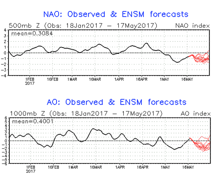
NAO (top) and AO (bottom) forecasted to spend much of the time in negative territory (red) as we go through the second half of May; courtesy NOAA
AO, NAO indices provide support for the Greenland block idea
Two indices that meteorologists can track in order to monitor the pressure patterns over the northern latitudes are the Arctic Oscillation (AO) and North Atlantic Oscillation (NAO). When these indices drop into negative territory for extended periods this time of year, the result is often an upper-level blocking pattern across the northern latitudes. In recent weeks, the AO and NAO have indeed been generally negative and strong blocking way up north has contributed to the recent chill across parts of the Northern Hemisphere. The NAO has been in negative territory in recent days and is forecasted to remain there (in red) during the last part of May. The AO is predicted (in red) to drop back into negative territory for the latter part of May after a brief uptick into the positive zone.
Meteorologist Paul Dorian
Vencore, Inc.
vencoreweather.com