12:15 PM | **July nor’easter for parts of the Mid-Atlantic region**
Paul Dorian
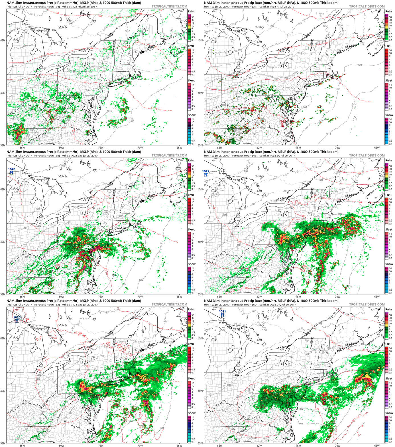
12Z high-resolution NAM (3km) surface and radar forecast maps from 8AM Friday morning to 8PM Saturday night; courtesy tropicaltidbits.com, NOAA/EMC
Overview
Ingredients are coming together for a storm to hit parts of the Mid-Atlantic region from later tomorrow into Saturday and it should produce some heavyrainfall, possible strong thunderstorms, and winds at the coastline of more than 40 mph. This unfolding scenario is somewhat analogous to wintertime nor’easters in the Mid-Atlantic region with strong surface low pressure near the coastline, chilly high pressure anchored to the north and west, and vigorous energy aloft. While there can be scattered showers and thunderstorms later today and tonight, the main event from this developing storm should take place from later tomorrow into Saturday morning.
Discussion
Vigorous energy in the upper atmosphere will slide across the Great Lakes region over the next 24 hours and this will ultimately result in a deep upper-level low over the Mid-Atlantic region. During the same time period, surface low pressure will form along a stalled out frontal boundary zone and it'll intensify as it pushes towards the Mid-Atlantic coastline.
Total precipitation amounts between now and 8PM Saturday night according to the 12Z version of the high resolution NAM model (3km). Courtesy tropicaltidbits.com, NOAA/EMC
On Friday, the lower levels of the atmosphere will remain fairly warm with temperatures likely climbing to 80+ degrees in the DC-to-Philly-to-NYC corridor and as colder air aloft spreads to the east coast, destabilization of the atmosphere will take place. The result could be some strong thunderstorm activity later tomorrow and tomorrow night which could result in heavy downpours. Indeed, with or without thunderstorm activity, the rain tomorrow night will likely fall heavily at times in the I-95 corridor region between DC and Philly - NYC should remain to the north of the heaviest rainfall. By Saturday, this system will become more like a typical wintertime nor’easter with stiff low-level NE winds and much cooler conditions in the I-95 corridor - perhaps even confined to the lower 70's. During this latter stage of the storm, the threat for strong-to-severe thunderstorms will diminish, but the rain can continue to be heavy at times. After all is said and done, there can be anywhere from 2 to as much as 4 inches of rain in parts of the Mid-Atlantic region (e.g., DC metro region, Delmarva Peninsula, southern NJ, southern half of Philly metro region). Given the already well-saturated grounds, flash flooding may become a problem – expect flash flood watches to be posted by the National Weather Service as we get closer to event time.
Meteorologist Paul Dorian
Vencore, Inc.
vencoreweather.com
Extended video discussion:


