11:45 AM | *Two tropical systems to monitor…one poses a major threat to Texas/Louisiana in terms of tremendous flooding potential…another could impact the Southeast US coastline with heavy rainfall*
Paul Dorian

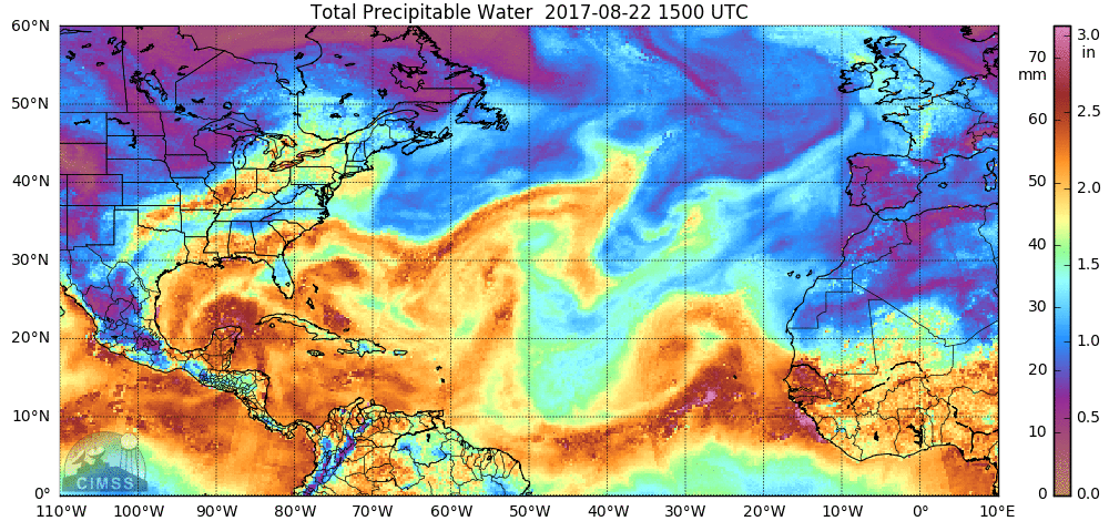
Precipitable water amounts are showing very high levels in the southwestern Gulf of Mexico associated with the remains of Tropical Storm Harvey; courtesy University of Wisconsin/CIMSS
Overview
There are currently two tropical waves of interest in and around the Gulf of Mexico and both appear to be headed for a period of intensification and slow-movement. This particular outlook for intensification and slow-movement raises the possibility for some excessive rainfall amounts in coming days; especially, from southeastern Texas to southwestern Louisiana and perhaps in the coastal region from Florida to North Carolina. There is yet a third wave of interest that looks quite impressive just now coming off the west coast of Africa in this typically climatologically-active time of year for the Atlantic Basin.

NOAA's forecast of precipitation amounts over the next 7 days with tremendous amounts associated with the two tropical systems
Threat of tremendous flooding rainfall in Texas and Louisiana
An area of showers and thunderstorms over the southwestern Gulf of Mexico are associated with the remnants of Tropical Storm Harvey and is very likely to undergo intensification over the next day or so. As a result, this tropical wave is likely to first regain status as a "tropical depression" and then to a re-named (Harvey) tropical storm and ultimately perhaps to a category 1 or 2 hurricane. The movement across the Gulf of Mexico will be in a general northwest fashion over the next couple of days and right towards the coast of southeastern Texas - perhaps to right near the region of Corpus Christi. Whether this system actually makes landfall in this area is still just too far away to be certain.
Once the tropical system nears the coastline of Texas, it is likely to begin to slow down in its forward progress due to upper-atmospheric conditions. Specifically, weak steering currents in the atmosphere could very well lead to a period in which this system stalls out completely or even performs some sort of a loop near the southeastern Texas coastline. This anticipated slow-movement or possible loop could lead to an extended period of very heavy rainfall from southeastern Texas into southwestern Louisiana. Precipitable water amounts are already very high in the vicinity of the re-developing tropical system (see loop of PW amounts above) and there are prospects for as much as two feet of rain in this region during the next week or so (some forecast models have even double that amount!!). Longer term, this tropical system is likely to make a turn to the northeast and could even ultimately result in some rainfall for the Mid-Atlantic region as the month of August winds down or the month of September gets underway.
One final note of interest regarding Texas, there has not been been any hurricane that has made landfall there since 2008 (Dolly, Ike).

Latest infrared satellite image features two tropical waves in and around the Gulf of Mexico (circled) and yet a third (and impressive) wave just off the west coast of Africa (circled); image courtesy University of Wisconsin/CIMSS
Southeastern US threat extends from Florida to North Carolina
There is a broad trough of low pressure near the southeastern coast of Florida and there is likely to be little in the way of intensification associated with this tropical wave over the next couple of days. However, overall environmental conditions are likely to become more favorable for intensification this weekend while the wave slowly churns over the rather warm waters of the western Atlantic Ocean. By this time, the wave will likely turn northeastward and move rather slowly along or just off the Southeast US coastline. As a result, significant rainfall is on the table for Florida in coming days and also along all coastal sections extending northeastward to the Outer Banks of North Carolina. If this system strengthens into "tropical storm" status – quite a realistic scenario over the next several days – it would officially become named “Irma”.
Stay tuned – the next six weeks or so should be quite an active time period in the Atlantic Basin and we'll soon turn our attention to the next tropical wave now just off of Africa.
Meteorologist Paul Dorian
Vencore, Inc.
vencoreweather.com