Tuesday 12:30 PM | **Accumulating snow from late tonight into tomorrow morning for DC, Philly, NYC**
Paul Dorian
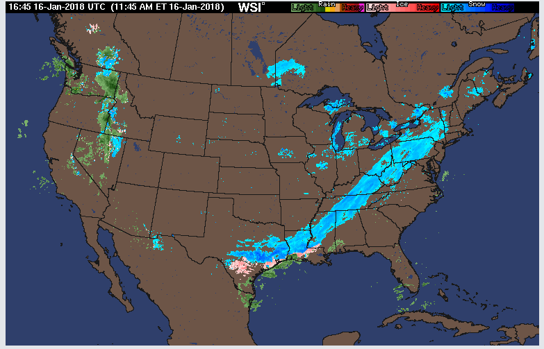
Mid-day radar map with snow (in blue) all along the southwest-to-northeast oriented frontal system that is slowly making its way to the east coast; map courtesy WSI, Inc., NOAA
Overview
An accumulating snow event is coming to the DC-to-Philly-to-NYC corridor from late tonight into tomorrow morning and there can be some problems with the Wednesday AM commute in all three metro regions. Cold air will stick around following this snow event for the latter part of the work week, but a noticeable warm up will take place this weekend and continue into next week.
Snowfall amounts as predicted by the 12Z NAM-3 km version for the upcoming event; map courtesy NOAA/EMC, tropicaltidbits.com
Details
Upper-level energy is sliding slowly across the Ohio Valley today and is oriented in a southwest-to-northeast direction. It will reach the east coast by later tomorrow and will help in the formation of low pressure near the Mid-Atlantic coastline on Wednesday. Meanwhile, a surface cold front is also playing an important role in this unfolding event as it will slide slowly towards the east coast as it will become aligned parallel to the upper-air wind flow (SW-to-NE) and grind to a halt. Much of the snow that falls late tonight/early tomorrow will actually take place just behind the frontal system and given its slow movement, it looks like there can be an extended period with snow in some areas.
The precipitation could actually begin briefly as rain or sleet in the immediate I-95 corridor, but should fall primarily in the form of snow late tonight and early tomorrow. As far as accumulations are concerned, the combination of the front and low pressure system should generate a coating to two inches of accumulating snow in the DC metro region, 1-3 inches in the Philly metro region with those higher amounts in the N and W suburbs, and 3-5 inches in and around the NYC metro region. Even heavier amounts are likely just to the west and north of the NYC metro region (e.g., 5-7 inches in the Poconos and interior northern New Jersey) and there can be heavier amounts south of DC as well in places like south-central Virginia (e.g., 3-6 inches in Richmond, VA). Coastal sections of New Jersey and the Delmarva Peninsula should see an inch or less of snow with this system and, in those areas, rain could actually last for a little while at the onset.
While there can be a snow shower at just about anytime during the next several hours, steadier snow is likely to hold off until after midnight and then continue into tomorrow morning with some impact possible for the Wednesday AM commute in all three metro regions. It'll stay cold following this system for the latter part of the work week with a reinforcing cold air mass ushered in by the cold frontal passage, but then a noticeable warm up will occur this weekend and continue into next week.
Weekend warm up
Last week's warm up was just a prelude to a likely longer-lasting thaw coming to the Mid-Atlantic region. Noticeably milder weather is going to return to the I-95 corridor during the upcoming weekend and continue into next week. Temperatures on Saturday are likely to reach the 40’s in most spots and then 50+ degrees is possible on Sunday making the Eagles playoff game considerably different weather-wise than last weekend. This warm up will extend into next week as well and some rain is possible by Tuesday or so.
Meteorologist Paul Dorian
Vencore, Inc.
vencoreweather.com


