11:00 AM | **An active 24 hours in the Mid-Atlantic region aided by a powerful jet streak in the upper atmosphere**
Paul Dorian

A powerful jet streak in the upper atmosphere will aid in the development of heavy rainfall and possible strong-to-severe thunderstorms; courtesy NOAA/EMC, tropicaltidbits.com
Overview
Quite an active weather pattern is setting up for the Mid-Atlantic region from later today until later tomorrow. A strong cold front is now slowly inching its way towards the east coast and low pressure will form along its boundary zone later today in the Mid-Atlantic region. This developing low pressure system will be aided by a powerful jet streak in the upper part of the atmosphere and the end result will be heavy rain in the DC-to-Philly-to-NYC corridor and the chance for some strong-to-severe thunderstorm activity with possible damaging wind gusts and even isolated tornadoes. In addition, once this system pushes off to the northeast on Saturday, the pressure gradient will tighten and NW winds could gust past 50 mph during the mid-day and afternoon hours in parts of the I-95 corridor.

Strong upward motion in the Mid-Atlantic region will help generate heavy rainfall in the DC-to-Philly-to-NYC corridor between now and Saturday morning; courtesy NOAA
Discussion
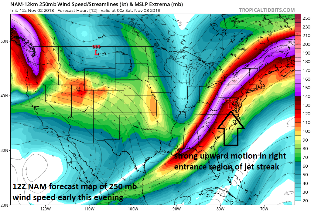
A "jet streak" refers to a portion of the overall jet stream where winds along the jet core flow are stronger than in other areas along the jet stream. “Entrance” and “exit” regions of jet streaks are very important in terms of vertical motion, surface pressure systems, and organized precipitation given sufficient low-level moisture. A powerful jet streak at 250 millibars will feature winds by this evening of greater than 175 mph and the right “entrance” region will be moving right over the Mid-Atlantic resulting in strong upward motion in the atmosphere.
As a result, radar is likely to explode later today as rainfall intensifies and becomes more widespread as it heads to the DC-to-Philly-to-NYC corridor and thunderstorms could also develop and reach strong-to-severe levels in spots. The rain will continue heavy at times through the night and into the early morning hours on Saturday before the system exits off to the northeast of here – but that will not be the end of the weather story.

A tight pressure gradient (indicated by “close together” isobars=black lines) on Saturday between the departing low pressure system and building high pressure will result in 50+ mph wind gusts in parts of the I-95 corridor; courtesy NOAA/EMC, tropicaltidbits.com
As high pressure begins to fill in on the back side of the departing low pressure system on Saturday, the pressure gradient will tighten and NW winds will potentially gust past 50 mph in some spots along the I-95 corridor during the mid-day and afternoon hours. These strong winds should quickly die down tomorrow night and this will result in a nice setup for radiational cooling and temperature should drop sharply to the middle 30’s for late night lows with the likelihood of scattered frost by early Sunday morning in outlying areas.
Following a tranquil, but chilly day on Sunday featuring some sunshine, yet another couple of disturbances will head towards the Mid-Atlantic region for the first half of next as this overall active weather pattern rolls on. The first system will come out of the Southeast US and head up along the east coast and likely result in additional rain around here later Monday. Another system will slide eastward on Tuesday from the Midwest and it is likely to bring about more shower activity Tuesday night and/or Wednesday.
One final note, this is the weekend to turn back the clocks which is always a sign that winter is not far behind.
Meteorologist Paul Dorian
Perspecta, Inc.
perspectaweather.com
Video discussion: