11:30 AM | *Wild swings coming next several days..."spring-to-winter-to-spring"...some accumulating snow still possible late Saturday*
Paul Dorian

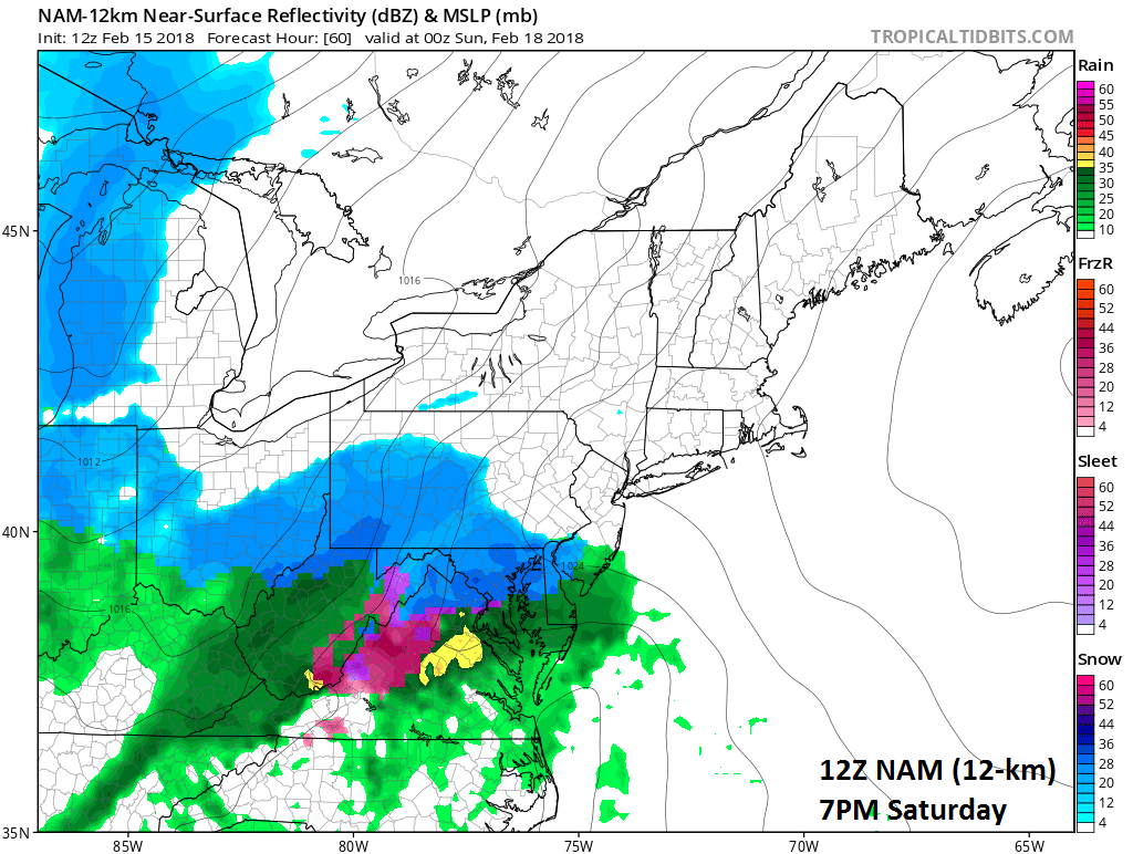
12Z NAM forecast map for 7PM Saturday evening (snow in blue, rain in green, ice in pink/purple); map courtesy NOAA/EMC, tropicaltidbits.com
Overview
A wild ride is in store for the DC-to-Philly-to-NYC corridor over the next several days going from spring conditions today to winter weather by the weekend and then back to spring weather by the middle of next week. Temperatures today should reach the 60’s in the I-95 corridor and then drop to the 20’s tomorrow night following the passage of a strong (and wet) cold front. Low pressure will then head towards the Mid-Atlantic coastline late Saturday and accumulating snow could fall in DC, Philly and NYC before a potential changeover to rain. Following that, much warmer air will flood the region during the early and middle parts of next week and the 60’s (or even higher) are likely on Tuesday and Wednesday.

12Z NAM forecast map for 10PM Saturday night (snow in blue, rain in green, ice in pink/purple); map courtesy NOAA/EMC, tropicaltidbits.com
Details
A warm front passed through the region in the overnight hours and temperatures this afternoon should jump to the 60’s despite plenty of clouds. This warm up, however, will be rather short-lived as a strong cold front arrives on Friday with rain coming in the overnight hours into early tomorrow and then much colder air will pour into the region later tomorrow and tomorrow night on increasing winds out of the NW.

12Z NAM forecast map for 1AM early Sunday (snow in blue, rain in green, ice in pink/purple); map courtesy NOAA/EMC, tropicaltidbits.com
On Saturday, cold high pressure will start the day nearby and low pressure will begin to pull out of the southern states and head towards the Mid-Atlantic coastline. This high pressure system will push off the coast by late Saturday and this will open up the door for precipitation to head our way from the southwest-to-northeast. The precipitation will likely arrive in the DC, Philly, NYC metro regions as snow late in the day on Saturday or early Saturday night and then it may mix with or change to rain, but likely not before some snow accumulations.

12Z NAM forecast map of total snowfall amounts by mid-morning Sunday; map courtesy NOAA/EMC, tropicaltidbits.com
Preliminary estimates for snowfall accumulations this weekend are as follows: a coating to a inch or two in the DC metro region and up to 2 or 3 inches possible in the Philly and New York City metro regions. The 12Z high-resolution (12-km) version of the NOAA NAM computer forecast model has snow at the onset in DC on Saturday (7PM forecast map) then a change to rain in DC by 10PM, but all snow in Philly at that time. At 1AM on Sunday, the 12Z NAM model forecast has already ended the precipitation in the DC metro region, and it has changed the snow to rain in Philly with snow falling in NYC at that particular time. This will be a fast-moving system and all precipitation is likely to be over with by very early Sunday morning. The best chance for accumulating snow during this weekend event will be to the north and west of the big cities with lesser chances to the south and east.

12Z GFS 850 mb temperature anomalies on Tuesday night with a major league warm up coming to the Northeast US; map courtesy NOAA/EMC, tropicaltidbits.com
Following the winter weather conditions of the weekend, a big warm up is likely to take place by the middle of next week in the Mid-Atlantic region in what is still an on-going overall mild weather pattern for mid-February. In fact, temperatures should climb to the 60’s next Tuesday and Wednesday in DC, Philly and NYC - perhaps even into the 70's in some spots for afternoon highs.
Stay tuned.
Meteorologist Paul Dorian
Vencore, Inc.
vencoreweather.com
Morning video discussion on the wild ride coming to the I-95 corridor: