12:55 PM | ****Significant snow threat Philly-to-Boston late Tuesday night/Wednesday; especially, to the N and W of the big cities...DC not totally in the clear****
Paul Dorian
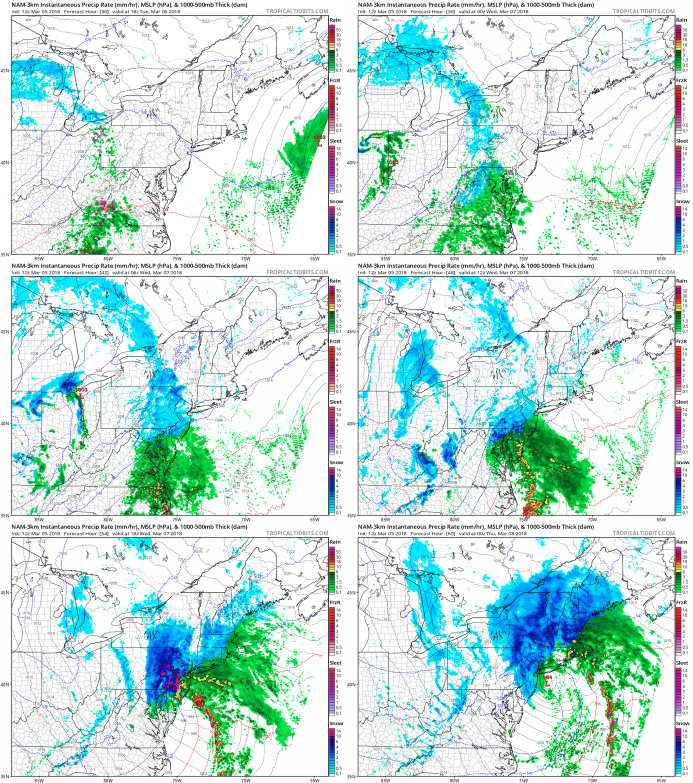
12Z high-resolution (3-km) NAM surface forecast maps from hour 30 to hour 60 (Tuesday afternoon-Wednesday evening). Intense snow bands predicted over eastern PA, interior NJ on Wednesday (red); maps courtesy NOAA/EMC, tropicaltidbits.com
Overview
High-latitude blocking over northern Canada/Greenland is very strong today and it will stay in place for the next several days during a stormy period for the Mid-Atlantic region. One coastal storm will intensify along the Mid-Atlantic coastline on Wednesday and likely bring a significant snow accumulation to much of the I-95 corridor from Philly-to-Boston; especially, in the northern and western suburbs of the big cities with 6+ inches on the table. Very chilly air for this time of year will follow the mid-week mauler and then another storm may threaten the Mid-Atlantic region next Sunday/Monday.
06Z GFS 500 mb height anomaly forecast map for this afternoon (strong high-latitude blocking circled region); map courtesy NOAA/EMC, tropicaltidbits.com
Tuesday night/Wednesday (Philly, NYC)
Low pressure will develop along the Carolina coastline on Tuesday night and then intensify rapidly as it rides right along the Mid-Atlantic coastline on Wednesday. Precipitation is likely to break out late tomorrow or early tomorrow night; primarily, in the form of rain, but as colder air gets wrapped into the system and “dynamical cooling” develops, the rain will change to snow in the overnight hours and snow will be the predominate type on Wednesday.
Some of the very latest high-resolution computer forecast models raise the prospects of heavy snow bands to form on Wednesday across eastern PA, interior NJ which, in turn, could lead to significant snowfall amounts for many of the suburbs to the north and west of Philly and NYC – perhaps on the order of 6+ inches. If these small-scale intense snowfall bands do form, they could dump a few inches per hour on Wednesday which would certainly allow for accumulations on all ground-level surfaces despite the marginally cold temperatures. Snow is likely to continue into late Wednesday; consequently, it looks like this storm may have an impact on both the Wednesday morning and evening commutes in the Philly and NYC corridor.
One final note, the threat of power outages has to be raised once again given the prospects of heavy, wet snow following the initial rain which would result in weighed down limbs and branches.
12Z Euro (left) has shifted west from its earlier run (00Z, right) for later Wednesday and this increases the chances for significant snow from Philly-to-Boston. Any additional shift from here could even increase snow accumulation prospects for the DC metro region; maps courtesy WSI, Inc.
Tuesday night/Wednesday (DC to coastal southern NJ)
In the DC metro region and areas east to coastal southern NJ, mixing of rain and snow will likely limit snowfall accumulations on Tuesday night and Wednesday to a range of a coating to perhaps 2 or 3 inches. However, just a small change in storm track would result in an extended period of "all snow" for these areas - and more significant accumulation amounts - something still definitely on the table for this region. Precipitation should break out late tomorrow in the form of rain and it should then change to a mix of rain and snow by early Wednesday and likely continue as a mix during the day; however, all snow is possible for awhile in these areas.
06Z GFS 850 mb temperature anomaly forecast map for days 3-7 (Wednesday-Sunday); map courtesy NOAA/EMC, tropicaltidbits.com
Late week cold/Sunday-Monday storm threat
Very chilly air for this time of year will follow this mid-week mauler and perhaps set the stage for another significant event. This is still in the speculation stage, but there are signs for a major storm system somewhere in the southeastern US come early next week (Sunday/Monday). It is still too early to tell if this storm will ride up the east coast or get shunted out-to-sea south of here and exactly where the rain/snow line would set up. The potential is there, however, for high precipitation amounts as it appears Gulf of Mexico moisture will get wrapped into the system.
06Z GFS 500 mb height anomaly forecast map for this Monday, March 12th (high-latitude blocking circled region); map courtesy NOAA/EMC, tropicaltidbits.com
Stay tuned…its going to be a wild ride over the next week or so.
Meteorologist Paul Dorian
Vencore, Inc.
vencoreweather.com
Extended morning video discussion on the major storm threats:


