3:00 PM | *Atmospheric instability is on the rise during this hot afternoon and scattered strong thunderstorms have formed*
Paul Dorian

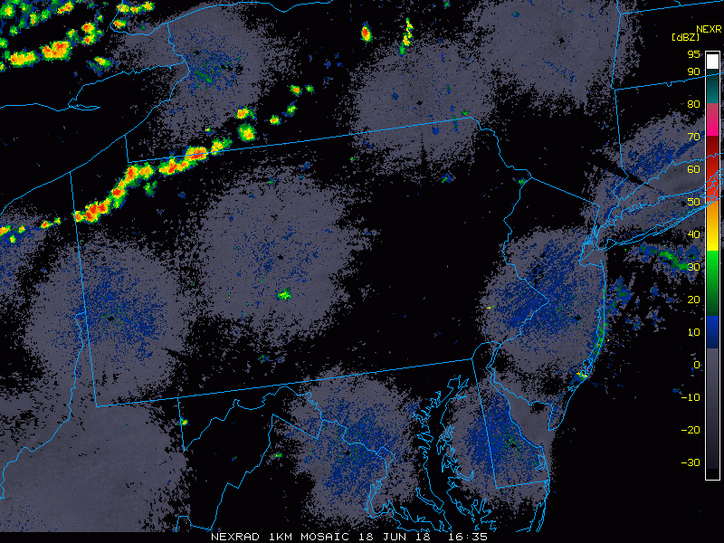
Thunderstorms have broken out ahead of a slowly advancing cool front and the atmosphere has become pretty unstable in the I-95 corridor; courtesy NOAA, College of DuPage
On this hot afternoon, thunderstorms are forming across upstate Pennsylvania as a cool front slowly advances towards the Mid-Atlantic region. Instability is on the increase in the I-95 corridor region as indicated by the noticeable rise during the past three hours in one instability parameter known as the “Convective Available Potential Energy (CAPE)”. As CAPE levels increase to unstable levels, a surface trough of low pressure has formed just to the east of the Appalachian Mountains and thunderstorms are heading into this particular unstable region.

The latest surface map features a trough of low pressure just to the west of the I-95 corridor; data courtesy NOAA
Temperatures at 2pm are generally at 90+ degrees in the I-95 corridor and dew points are at very uncomfortable levels of 70+ degrees. While these thunderstorms are of the scattered nature, any spot that gets hit by one can experience brief heavy rainfall. The threat for thunderstorms will be greatest from late this afternoon into the overnight hours and highest in areas near and north of the PA/MD border.

The atmosphere has become quite unstable in the I-95 corridor as indicated here by a substantial increase in Convective Available Potential Energy (CAPE) during the last three hours; data courtesy NOAA
This same cool front will help in reducing the heat on Tuesday and Wednesday, but it’ll stall out in the general vicinity. As a result, conditions will remain unsettled over the next couple of days and low pressure may ride along the frontal boundary zone late Wednesday enhancing the chance for additional rainfall in the I-95 corridor.
Meteorologist Paul Dorian
Perspecta, Inc.
perspectaweather.com

Actual CAPE values during the mid-afternoon hours shows values of 3000+ (unstable) just to the west of the I-95 corridor; data courtesy NOAA