12:00 PM (Tuesday) | *****High impact storm to bring accumulating snow, ice, rain, and strong winds to the Mid-Atlantic/Northeast US from later tomorrow into early Thursday****
Paul Dorian

12Z HRRR surface forecast map for early tomorrow night with snow (blue) and ice (pink, purple) and rain (green, yellow). Map courtesy NOAA, tropicaltidbits.com
Overview
A high impact storm is coming to the Mid-Atlantic/Northeast US at mid-week with significant snow for some, ice and rain for others and winds will become a big factor as well. The big cities along the DC-to-Philly-to-NYC corridor will have accumulating snow as well as a period of mixed precipitation and the heaviest snowfall amounts will be on the northwest side of the I-95 corridor. Rain will dominate in areas from coastal southern New Jersey to the southern half of the Delmarva Peninsula to southeastern Virginia.

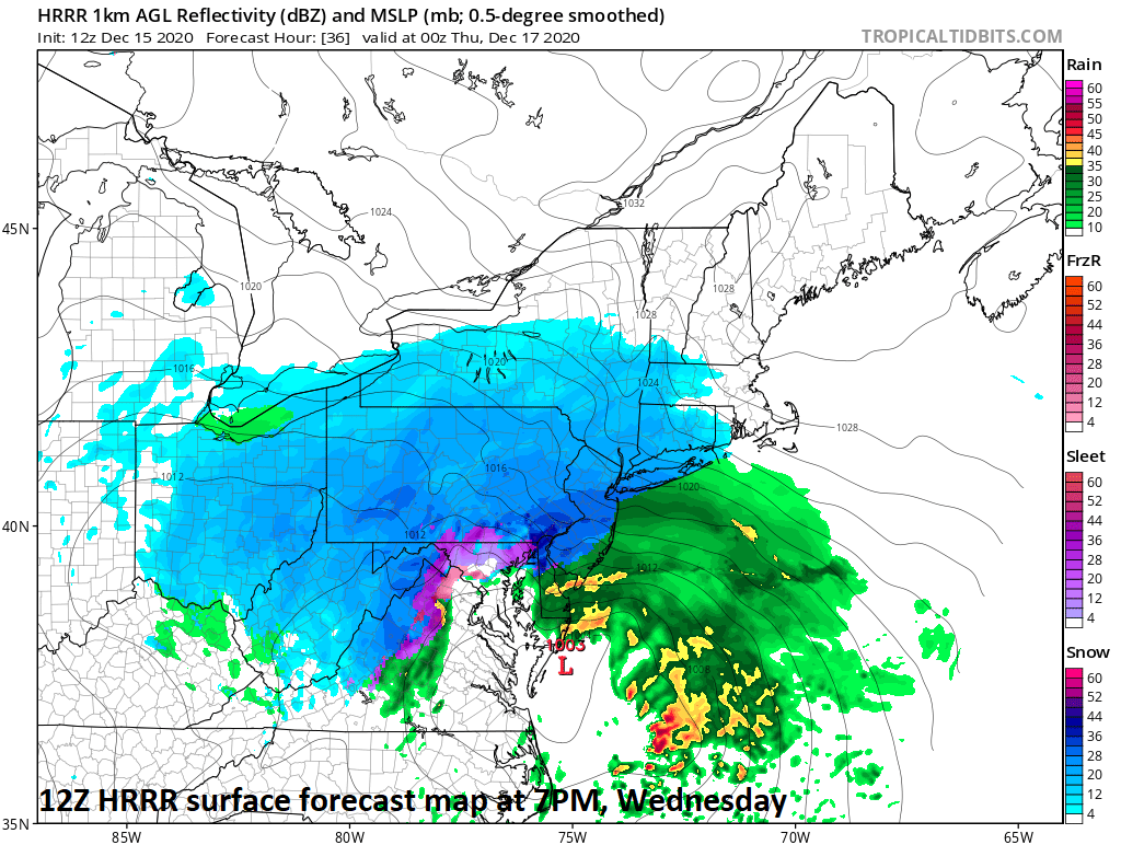
12Z HRRR surface forecast map for late tomorrow night with snow (blue) and ice (pink, purple) and rain (green, yellow). Map courtesy NOAA, tropicaltidbits.com
Details
On Wednesday morning, very strong and cold high pressure will be anchored across southeastern Canada at the same time low pressure will be developing along the Carolina coastline. The high pressure system to the north is a key reason as to why this mid-week storm will be a high impact system in the Mid-Atlantic and Northeast US. Dense, cold air will be difficult to dislodge on Wednesday and Wednesday night resulting in frozen precipitation for much of the Mid-Atlantic and Northeast US. From the Carolina coastline, the low pressure system will push northward to southeastern Virginia and then to the Delmarva Peninsula by early tomorrow night. After that, the low will make a bit of a turn and push more to the northeast instead of to the north resulting in a position east of New Jersey by the late night hours.
Snow is likely to break out at the onset of the storm during the late morning hours in DC, early-to-mid afternoon hours in Philly, and then during the late afternoon hours in NYC. While this low pressure system is moving over the Delmarva Peninsula, counter-clockwise winds will push milder air inland from the still relatively warm western Atlantic Ocean. This low-level wind flow will very likely result in a changeover from all snow to mixed precipitation (sleet, freezing rain) in the DC and Philly metro regions and perhaps even in as far north as the NYC metro region. If the low pressure system ends up going a little farther to the north then the low-level warming could push even farther inland and this possibility is something to monitor over the next 12-24 hours.

The western Atlantic Ocean still features relatively warm sea surface temperatures with nearly 60 degree (F) water just off the tip of the Delmarva Peninsula. Map courtesy NOAA, tropicaltidbits.com
In areas not too far to the north and west of Route I-95, any time period with a mixture of precipitation will be rather short compared to in the immediate metro regions. Consequently, total snowfall accumulations can be considerably higher in many of the outer suburbs of the big cities compared to the immediate metro areas. In fact, there can be a very sharp gradient of snowfall amounts over a distance of just 25-50 miles or so from the metro regions to their far northern and western suburbs – makes for a tricky forecast.

Winds will become an important player in this upcoming storm with 50+ mph gusts along coastal sections and 40+ mph gusts inland. Map courtesy ECMWF, Weather Bell Analytics
In addition to the potential of accumulating snow, two other weather parameters will be of concern during this event. First, ice is likely to be a threat in parts of the Mid-Atlantic region as surface temperatures remain at or below freezing while milder air forced aloft causes sleet or freezing rain to fall. One such region where this could become a big issue during this mid-week storm is to the west and northwest of Washington, D.C. and it’ll be something to closely monitor over the next 12-24 hours. Second, winds can become quite a problem during the brunt of the storm with gusts possible of 40+ mph at inland locations and 50+ mph at coastal locations.. This type of strong wind combined with accumulating ice and/or wet snow can certainly result in some power outages during the mid-week storm.
A couple of other notes, there is likely to be “mesoscale” or small-scale bands of heavy precipitation during this storm which can lead to intense snow (or sleet) in some areas with much less intense snow (or sleet) nearby. Also, it is not out of the question that some convective activity develops in parts of the Mid-Atlantic region during this storm with “thunder snow” on the table.

The latest 12Z Euro “snow depth” forecast map is shown here for the mid-week event. “Snow depth” forecast maps may look quite different than the conventional “total snowfall amounts” forecast maps which do not take into account “melting” or “compacting”. For this type of storm that is on the way, the “snow depth” forecast map may be more informative than the “total snowfall amounts” map since icing will be quite significant in some areas (i.e. “compacting”). Map courtesy NOAA, Pivotal Weather
The latest snowfall estimates are as follows and they are still subject to change as a small shift in the storm track can make a big difference:
DC: 1-3 inches in the District, 3-6 inches in the N/W suburbs
Philly: 4-8 inches in Philly, 6-12 inches in the N/W suburbs
NYC: 6-12 inches throughout the metro region
Meteorologist Paul Dorian
Perspecta, Inc.
perspectaweather.com
Follow us on Facebook, Twitter, YouTube
Extended video discussion: