
2:45 PM (Thursday) | *Volatile weather pattern continues next week and a Christmas cold blast is in the cards for the eastern US…snowfall info from the 12/16-17 winter storm*
Paul Dorian

Signs point to a widespread cold blast for the central and eastern US later next week. This cold blast could reach the eastern US just in time for Christmas Day (Friday). Map courtesy NOAA, tropicatidbits.com
Overview
The first major winter storm of the season for the Mid-Atlantic/Northeast US is winding down today and there will be lots of cold air in its wake. In fact, the next several days are likely to remain colder-than-normal in the eastern US and there are increasing signs for a significant cold blast late next week – just in time for Christmas Day. In addition to the threat for more cold weather, it looks like volatile weather will continue next week and beyond with several impressive waves of energy to monitor that will be heading into the eastern states.

A volatile weather pattern will continue next week in the eastern US with this wave of interest (circled) on Tuesday, December 22nd. Map courtesy WSI, Inc., NOAA
Next week’s outlook
Yesterday’s major winter storm resulted in accumulating snow in many areas, ice and rain in others, and its widespread impact in the Mid-Atlantic/Northeast US was set up by a very cold air mass anchored by high pressure across southeastern Canada. In the wake of the storm, it’ll remain quite cold for the next few days and temperatures over the next couple of nights can drop into the teens in many suburban locations along the I-95 corridor. Next week promises to remain rather chilly and there are increasing signs that a very cold air mass will drop southeastward from Canada into the eastern US by the end of the week – perhaps arriving just in time for Christmas Day.
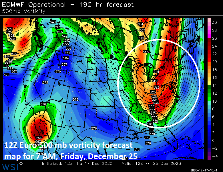
A volatile weather pattern will continue next week in the eastern US with this wave of interest (circled) on Christmas Day (Friday), December 25th. Map courtesy WSI, Inc., NOAA
In terms of the potential for storminess in coming days, there are two impressive waves of energy that will have to be closely monitored next week as they drop southeastward into the eastern states and the volatile weather pattern is likely to continue into the following week as well. The first wave of energy to deal with next week will tend to take on a “negative” tilt as it moves overhead in the Mid-Atlantic region in the Monday/Tuesday time frame. This could result in low pressure along the east coast and it is something to watch in coming days.
Later in the week, a strong cold front at the leading edge of potentially the coldest air mass so far this season will be crossing the central states and it may arrive in the eastern states around Thursday, Christmas Eve Day. The leading edge of this cold air mass will be accompanied by lots of energy aloft and there is a threat for strong low pressure to form later Thursday or Friday near the east coast. This will be in the area of the advancing frontal boundary zone that will feature a very tight temperature gradient. This type of pattern generally results in more favorable chances for snow across interior sections of the Mid-Atlantic/Northeast US, but it is something to monitor even in the immediate I-95 region. Whether or not this storm actually materializes, it appears that a very cold air mass may arrive in the eastern states just in time for Christmas Day (Friday).
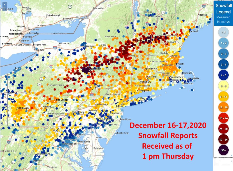
Snowfall info from yesterday’s storm
In the Philly metro region:
Exton 6.0”, King of Prussia 6.5”, Chadds Ford 6.8”, Sellersville 8.4”, Philly Intl Airport (PHL) 6.6”.
Note- Philly has had only 11 Decembers in which they observed 6” or greater and in 10 of those 11 years, there was another 6+ inch snowfall during that winter.
In the DC metro region:
Dulles (IAD) 2.3”, Vienna 2.3”, Silver Spring 1.5”, Front Royal (VA) 7.0”, DCA Trace
In the NYC metro region:
JFK Airport 6.2”, LGA 9.0”, Central Park 10.0”
Note- This was the largest December snowfall at Central Park since 2010.
The highest snowfall report in the Mid-Atlantic/Northeast US (as of mid-day Thursday) from the 12/16-17 storm was in Newark Valley, NY where 44 inches was observed.
Meteorologist Paul Dorian
Perspecta, Inc.
perspectaweather.com
Follow us on Facebook, Twitter, YouTube