
11:15 AM | *Milder on Thanksgiving Day…windy and cold on Friday…threat for some snow remains on the table for the Mid-Atlantic/Northeast US in the Sunday/Monday time frame*
Paul Dorian

Multiple disturbances aloft and their ultimate interaction with each other will be key to the late weekend/early next week threat of snow in the Mid-Atlantic/Northeast US. Map courtesy NOAA, tropicaltidbits.com
Overview
Today remains colder-than-normal in the Mid-Atlantic/Northeast US, but conditions will be much less harsh than they were on Tuesday with little to no wind to speak of and plenty of sunshine. Milder weather pushes in on Thursday, Thanksgiving Day, but the warm up will be short-lived. Another cold air mass arrives on Friday in the northeastern quadrant of the nation and the big shopping day will become quite windy with gusts past 35 mph to go along with below-normal temperatures. It stays cold this weekend and there remains a threat for some snow in the Mid-Atlantic/Northeast US on Sunday and/or Monday.
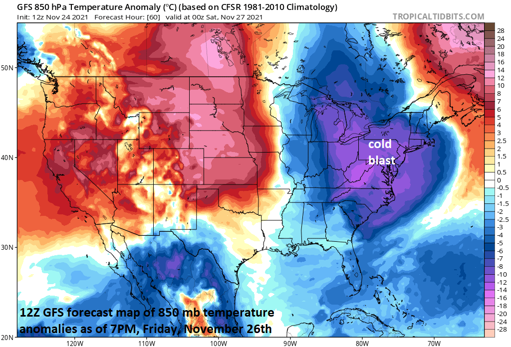
Another cold blast will arrive in the Mid-Atlantic/Northeast US on Friday and it will be accompanied by strong winds on this busy shopping day. Map courtesy NOAA, tropicaltidbits.com
Details
Temperatures will hold at below-normal levels today in the Mid-Atlantic/Northeast US, but with much less wind than yesterday and plenty of sunshine, it’ll feel a lot better. Milder air pushes into the eastern states on Thursday as a low-level SW flow of air develops on the back side of high pressure off to the east. The warm up on Turkey Day will be short-lived as another strong cold front arrives by early Friday and the day will turn out to be quite windy with gusts past 35 mph to go along with colder-than-normal conditions.
The weekend begins on the cold and dry side and then attention will turn upstream for the next in a series of disturbances that will drop south and east out of Canada into the US. Two disturbances will actually drop to the south and east late this weekend from Canada into the US and their interaction with each other will be key as to how much snow can fall in the Mid-Atlantic and Northeast US. Low pressure will likely form near the Mid-Atlantic coastline and then intensify as it turns up along the Northeast US coastline as these two upper-level disturbances coalesce. As a result, the odds are better for accumulating snow in the Northeast US as compared with the Mid-Atlantic region, but all options are still on the table…stay tuned.
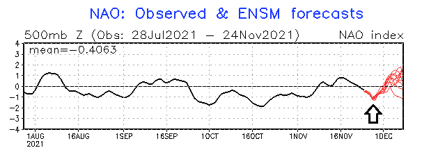
The NAO teleconnection index will drop further into negative territory over the next couple of days and then is forecasted to take a sharp turn towards neutral/positive. Plot courtesy NOAA
One of the signals that supports this idea of a formation of low pressure near the east coast is a teleconnection index known as the North Atlantic Oscillation (NAO). This index is likely to drop further into negative territory over the next couple of days and then rise sharply back towards the neutral line and then perhaps into positive territory. Often times a quick transition in this particular teleconnection index this time of year is associated with storm development near the eastern seaboard. Whatever does or does not happen with respect to the late weekend snow threat, it’ll remain colder-than-normal in the Mid-Atlantic/Northeast US right through the early part of next week following the one-day warm up on Thursday.
Meteorologist Paul Dorian
Video discussion: