1:50 PM (Monday) *”April is the cruelest month”…winter is not going away without a fight…nor’easter later in the week can bring snow to interior, higher elevation locations of the Northeast US*
Paul Dorian
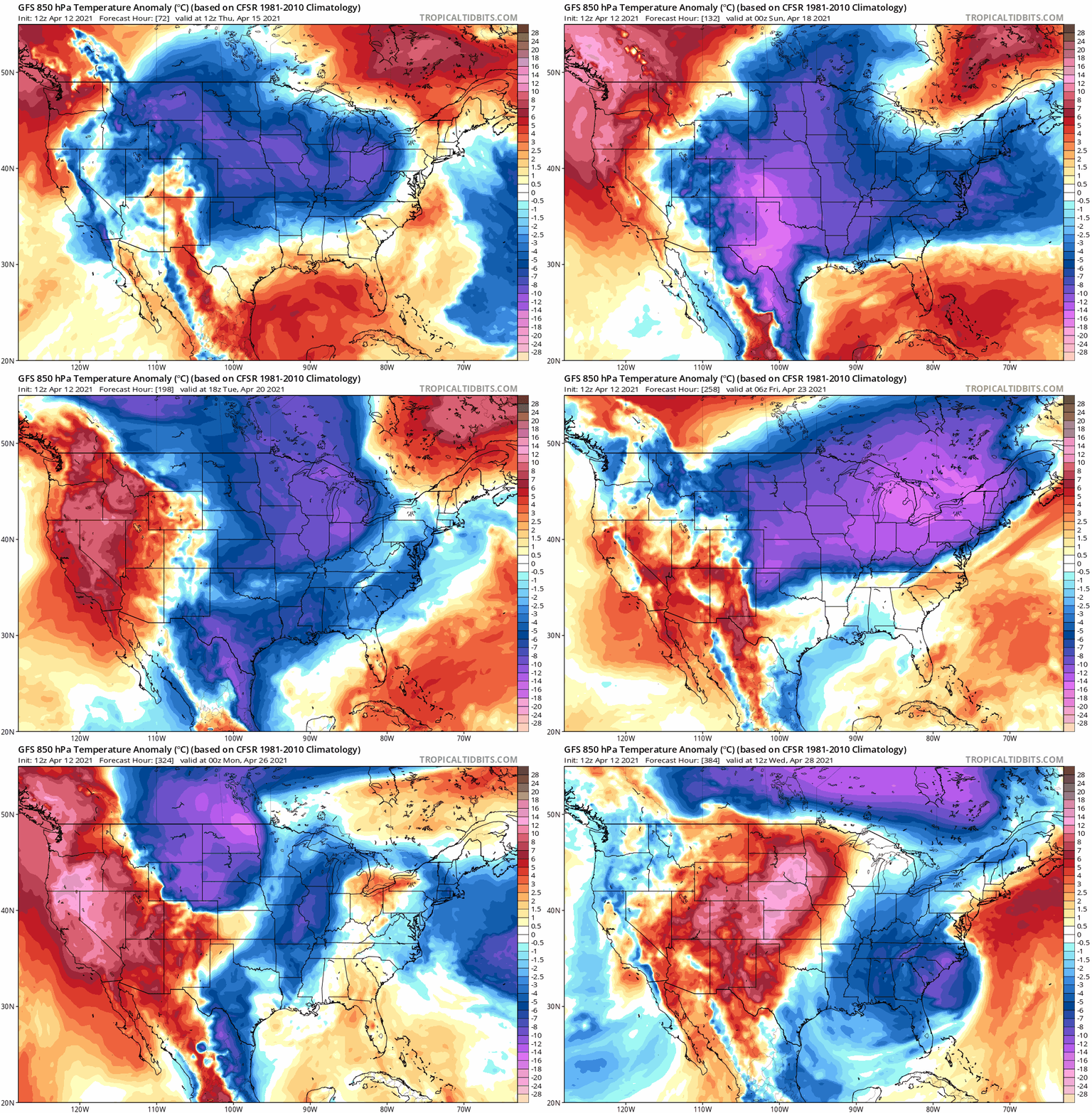
Multiple shots of colder-than-normal air will drop into the central and eastern US from Canada as we progress through the month of April. Maps courtesy NOAA, tropicaltidbits.com
Overview
To quote T.S Eliot…“April is the cruelest month”. Just when most desire the sustained warmth of spring, the weather pattern in the Northeast US can take a nasty turn and that unwelcome change is now unfolding as we approach the middle of the month. Last week featured some extreme cold in Alaska where some of the lowest temperatures ever for April were experienced and there was some very cold air in Europe as well. All of this took place while much of the US enjoyed generally warm and dry weather from coast-to-coast. That enjoyable pattern is certainly going away for the northeastern quadrant of the nation where below-normal temperatures may be the theme through the remainder of the month of April.
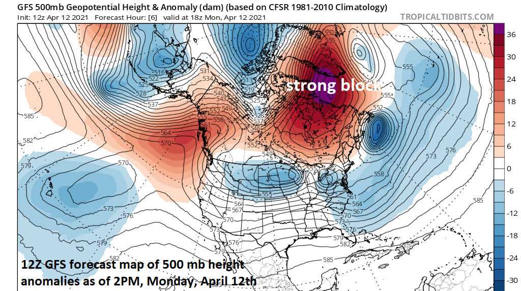
As is often the case with a sustained -NAO, strong blocking has formed over Greenland/northeastern Canada and that usually results in some nasty weather for the Northeast US during the month of April. Map courtesy NOAA, tropicaltidbits.com
Details
The teleconnection index known as the North Atlantic Oscillation (NAO) fell into negative territory last week and it has been sustained in that zone for several days now and this is often correlated with chilly weather in the Northeast US during the month of April. Indeed, a strong blocking pattern has formed across northeastern Canada and Greenland and this is usually enough to result in cold air outbreaks that make it into the central and eastern US from Canada.
Accumulating snow is on the table later this week across interior, higher elevation locations of the Northeast US as a nor’easter forms in a chilly air mass. Map courtesy NOAA, tropicaltidbits.com
A cold air outbreak that was bottled up over Alaska last week is now making a move to the central US – albeit in a modified form – and it will be part of a pattern change that will bring colder-than-normal temperatures to much of the central and eastern states later this week. To make matters worse, it looks like this initial shot of chilly air will be followed by multiple other cold air outbreaks for the central and eastern as we progress through mid and late April.
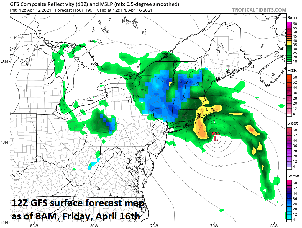
The 12Z GFS forecasts snow (shown in blue) on Friday morning across interior, higher elevation locations of the Northeast US. Map courtesy NOAA, tropicaltidbits.com
In addition to the chill, there is the threat for some springtime accumulating snow later this week across interior, higher elevation locations of the Northeast US. As a deep upper-level low pushes into the eastern states, low pressure will form near the Mid-Atlantic coastline on Thursday and intensify as it slowly pushes to the northeast late in the week. With chilly air in place, some accumulating snow is possible across such higher-elevation places as upstate eastern New York State and interior New England. Given the strong blocking pattern in the upper atmosphere across Greenland and northeastern Canada, this nor’easter type of storm is likely to slow down in its advance to the north and east – prolonging the misery for New England through the day on Friday. Beyond this next shot of chilly air, all signs point to additional cold air outbreaks to make their way from Canada into central and eastern US as we progress through the remainder of the month of April…often the cruelest month of all.
Meteorologist Paul Dorian
Perspecta, Inc.
perspectaweather.com
Follow us on Facebook, Twitter, YouTube
Video discussion:


