
2:15 PM (Wednesday) ****The threat of heavy rain/strong storms continues in the Mid-Atlantic region***
Paul Dorian
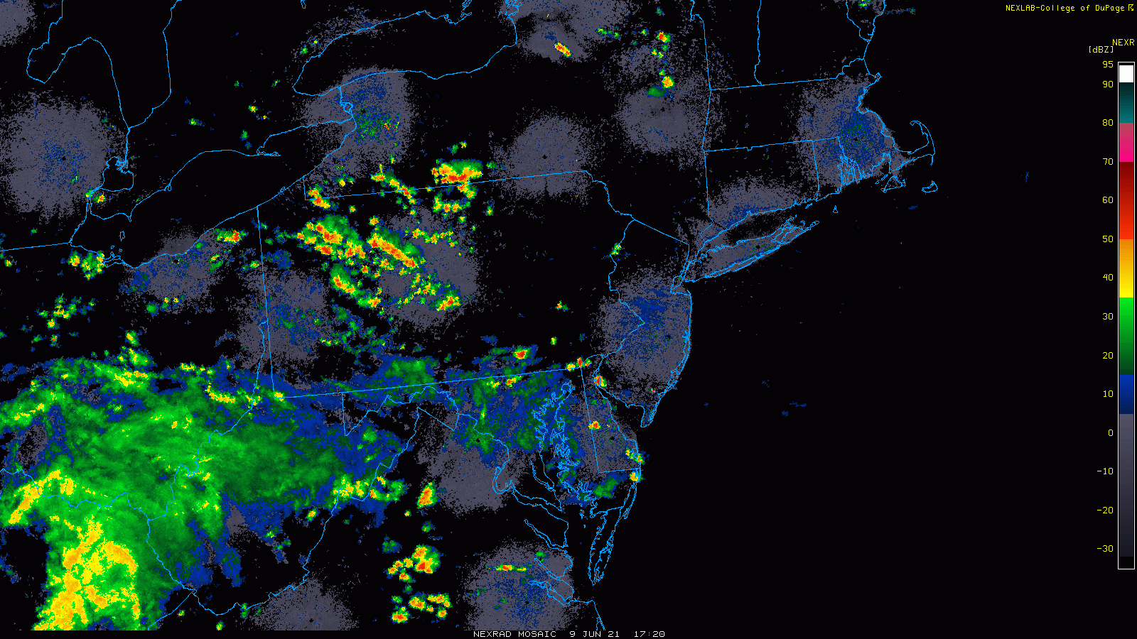
Showers and storms are breaking out across the Mid-Atlantic region and they’ll tend to drop from north-to-south later in the day as a cold front advances from north-to-south. Radar images courtesy College od DuPage, NOAA
Overview
The combination of a very moist air mass, a southward-advancing cold front, and an unstable atmosphere is resulting in more shower and thunderstorm activity for the Mid-Atlantic region. Any shower or thunderstorm that hits a given area later today/early tonight can produce flash flooding conditions given the general slow movement and the abundance of available moisture. Late yesterday and early last night, the “bulls eye” of the heaviest rainfall took place in Chester County, PA, but today’s threat will extend southward to southern New Jersey, the Delmarva Peninsula, and the DC metro region.

A high-resolution forecast model features southward-moving thunderstorm activity later today and early tonight as a cold front drops from north-to-south across the Mid-Atlantic region. Maps courtesy NOAA, tropicaltidbits.com
Details
The air mass is extremely moist in the Mid-Atlantic region and an advancing cold frontal system from the north-to-the-south is causing instability in the atmosphere and showers and storms are breaking out in the early afternoon hours. The threat for showers and storms will exist into the late evening hours as a cold front arrives from the north and acts to bring an end to the latest activity. The wind field in the lower and middle levels of the atmosphere is very weak and this is resulting in slow-moving shower and storm cells – much like yesterday – and the result can be some torrential rainfall amounts in a given area. In yesterday’s outbreak, parts of SE PA (Chester County) received as much as 6 or 7 inches of rain and any additional rainfall later today/tonight can bring about additional flash flooding. In fact, flash flooding can take place pretty much anywhere in the Mid-Atlantic region later today/tonight given the amount of moisture available in the atmosphere and ready to be “squeezed out” by an incoming frontal system.

Excessive rainfall fell yesterday across portions of SE PA (e.g., Chester County) making that area especially vulnerable to flash flooding later today/early tonight with any additional rainfall. Today’s threat of heavy rainfall will extend southward to southern NJ, the Delmarva Peninsula and the DC metro region. Map courtesy NOAA
Following the frontal passage, slightly cooler air will push into the Mid-Atlantic region on Thursday, but the front will tend to stall out just to the south of DC. While upstate NJ and NYC can experience a dry day on Thursday, the stalled-out front could result in additional showers and storms from Philly area southward to the DC metro region. It turns even cooler on Friday and if a northeast wind can get established, highs may be closer to the 70 degree mark than the 90 degree mark of the past few days. The weekend could turn out to be pretty decent generally with comfortably warm conditions and plenty of rain-free time.
Meteorologist Paul Dorian
Peraton
peratonweather.com
Follow us on Facebook, Twitter, YouTube
Video discussion: