
8:15 AM (Saturday) | *****Rapidly deteriorating conditions to follow Arctic frontal passage with wind-whipped snow along DC-to-Philly-to-NYC corridor...high winds into early Sunday*****
Paul Dorian

Strong mid-level frontogenesis will result in heavy snow bands following the passage of the Arctic front. Map courtesy NOAA/WPC
Overview
Many ingredients are coming together for a wild weather day in the DC-to-Philly-to-NYC corridor. These ingredients include strong jet streaks at multiple layers of the atmosphere, strong mid-level frontogenesis, and a phasing together of vorticity maxima in the southern and northern branches of the jet stream. Low pressure is now located over southeastern Virginia and it will push along an Arctic frontal boundary zone today while strengthening rapidly. The result will be near blizzard conditions in parts of the I-95 corridor for a period of a few hours with the combination of heavy snow and strong winds. High winds will continue through early Sunday with gusts past 50 mph potentially leading to some downed tree limbs and power outages.

Low pressure is currently centered over SE Virginia and will intensify rapidly today as it pushes to the northeast along an Arctic frontal boundary zone. Map courtesy NOAA/WPC
Details
Rain has already begun its change to snow in the DC metro region and this transition is advancing from west-to-east. The rain that is currently falling over southeastern PA will change to snow during the mid-morning hours with some sleet mixed in during the transition. The transition from rain-to-snow in the NYC metro region is likely to come during the late morning and mid-day hours.
One of the key ingredients in this active weather pattern is “mid-level frontogenesis” and it will produce mesoscale banding of heavy precipitation on the cold side of the front later in the morning in parts of the I-95 corridor. As a result, there can be wind-whipped snow at times - in other words - blizzard-like conditions. Travel will get quite hazardous today following the changeover to snow as accumulations will begin pretty quickly given the sharp drop in temperatures. The wet grass and trees from pre-frontal rains will also help result in a rather quick accumulation of snow as it will tend to cling to these surfaces. In addition to the wind-whipped snow causing travel problems, salt and brine solution will not be of much help today as pre-frontal rainfall likely washed away any that remained from prior applications. The steadier snow will wind down in the mid-day/early afternoon hours, but there can be additional snow showers and perhaps even isolated heavy snow squalls from this afternoon into the early evening hours along the I-95 corridor - the result of additional “mid-level frontogenetic forcing”.
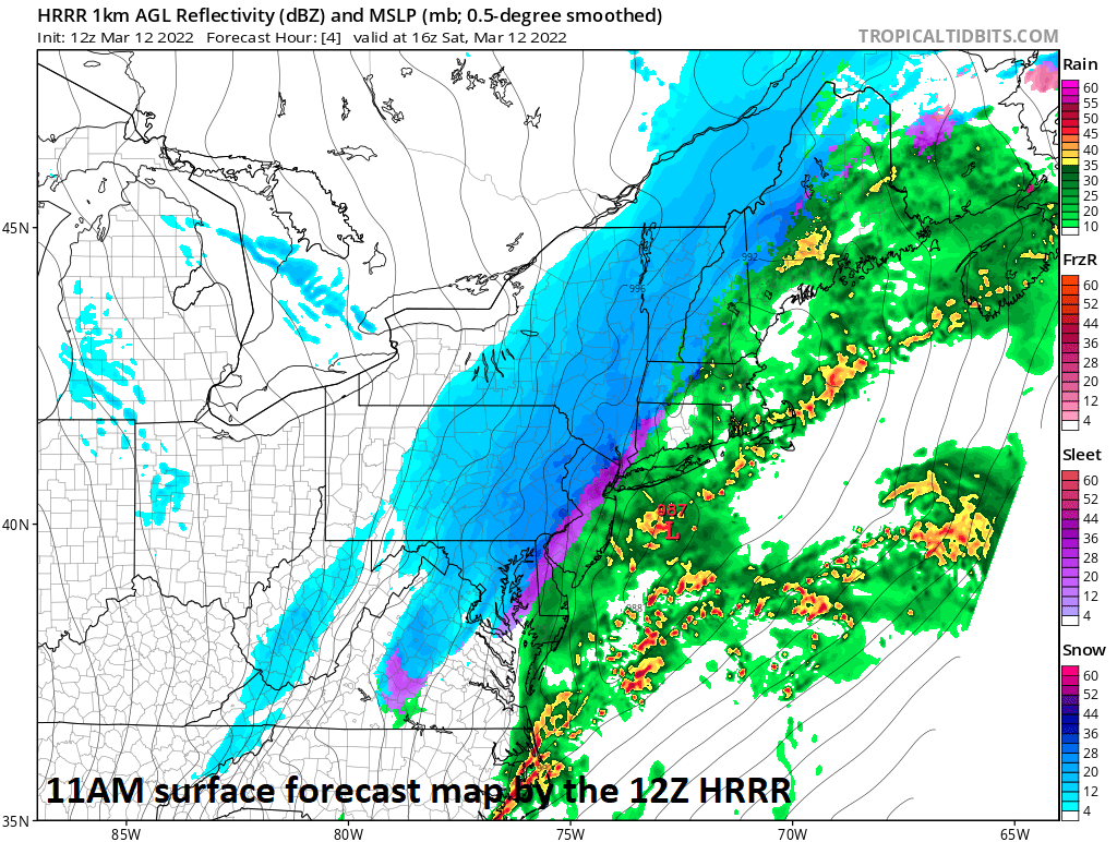
By mid-day, much of the transition of rain (in green/yellow) to snow (in blue) will have taken place along the DC-to-Philly-to-NYC corridor. Map courtesy NOAA, tropicaltidbits.com
Winds have already reached gusts of 40 mph in the DC metro region and will continue to intensify today as low pressure rapidly strengthens on its way from southeastern Virginia to northern New England. A very tight pressure gradient will develop between the intensifying low pressure system and a strong high pressure system building over the southern states. The result of this tight pressure gradient will be wind gusts of 50+ mph from later today into early Sunday and this kind of intensity can certainly raise the possibility of some downed tree limbs and power outages.
Here are snowfall estimates for the DC-to-Philly-to-NYC corridor:
DC metro region: 1-3” DC and nearby suburbs; 3-5” possible far N/W suburbs
Philly metro region: 1-3” Philly and nearby suburbs; 3-5” possible far N/W suburbs
NYC metro region: Coating-2”
Note: slightly lesser amounts of snow are expected in the NYC metro region as compared to DC and Philly since the storm will tend to accelerate on its push to the northeast. In other words, the NYC metro area will be in the cold air for a shorter period of time than DC and Philly while the precipitation still falls.
Final note: its time to turn the clocks ahead by an hour early Sunday morning.
Meteorologist Paul Dorian
Arcfield
arcfieldweather.com
Follow us on Facebook, Twitter, YouTube
Friday’s video discussion: