12:15 PM | ***Strong-to-severe thunderstorm threat late today/tonight in the DC-to-Philly-to-NYC corridor***
Paul Dorian
“Bulk shear” is quite high at mid-day in portions of the Mid-Atlantic region and this kind of atmospheric condition will enhance the chances for damaging wind gusts in any thunderstorm development later in the day and tonight. Map courtesy NOAA/WPC
Overview
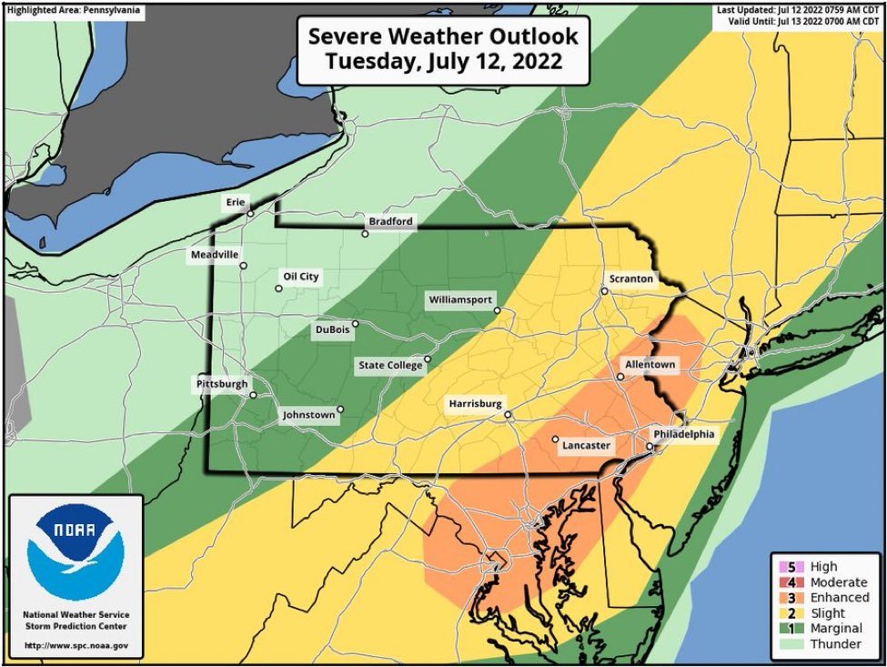
A combination of an approaching cold front, upper-level support, and a very warm and humid low-level air mass will result in a strong-to-severe thunderstorm threat in the DC-to-Philly-to-NYC corridor late today and tonight. The most likely timetable for this severe weather threat in the I-95 corridor will be 4-10pm with damaging wind gusts and downpours on the table.
An “enhanced” risk for severe thunderstorm activity later today/tonight exists in the DC-to-Philly-to-New York City corridor.
Details
A cold front is now pushing into the northwestern part of Pennsylvania and there is a pre-frontal trough of low pressure extending from central Virginia into central Pennsylvania. This pre-frontal trough could serve as the focus area for thunderstorm development later this afternoon as upper-level support moves overhead.
Another ingredient to the severe weather threat is the very warm and increasingly humid air mass that is moving into place in the lower levels of the atmosphere. Surface heating will lead to increasing instability in the atmosphere and southwesterly winds at the ground level are pumping in more humid air to the Mid-Atlantic region resulting in a noticeable rise in dew points.
A high-resolution forecast map for 6pm, Tuesday, depicts scattered-to-numerous thunderstorms in the Mid-Atlantic region…some of these storms can be strong-to-severe. Map courtesy NOAA, tropicaltidbits.com
One other parameter that I’m monitoring for this unfolding severe weather threat is “wind shear” which refers to the variation of wind speed and direction within a short distance in the atmosphere. With bulk shear values in excess of 40 knots – as is the case now in the Mid-Atlantic region – the chances become higher for damaging wind gusts in any thunderstorms that form later in the day. Also, there is enough low-level wind shear to potentially spin up a tornado or two though the odds are higher for the damaging wind gusts.
As is often the case in summertime patterns, the cold front that comes through the region later tonight will tend to stall out in the southern Mid-Atlantic region. While humidity should drop on Wednesday, the proximity of the stalled-out front will keep it somewhat unsettled as we go through the second half of the work week with a shower or thunderstorm possible on each day. Finally, there continues to be no sustained heat in sight for the Mid-Atlantic region. In fact, some western suburbs of Philly have still not reached the 90 degree mark which hasn’t happened this late in the season since the summer of 2015 (source: ChescoWx, Twitter).
Meteorologist Paul Dorian
Arcfield
arcfieldweather.com
Follow us on Facebook, Twitter, YouTube
Video discussion:


