
2:30 PM | ***A more active weather pattern and a cold air outbreak to sweep across the nation next week…just in time for Thanksgiving Day...teleconnection indices support change to cold***
Paul Dorian

A cold air outbreak is destined to sweep across much of the nation next week…just in time to make for a cold Turkey Day for many. This 12Z Euro forecast map of 850 mb temperature anomalies on Thanksgiving Day represents a big flip by the Euro compared to its prior runs which had been considerably warmer in the eastern states. Map courtesy Pivotal Weather, ECMWF
Overview
The overall weather pattern has been rather quiet across much of the nation in recent days, but a more active pattern appears to be setting up as we approach the middle of November. In the near term, a strong storm system will slide east across the Gulf of Mexico producing significant rainfall in the region from Louisiana to Florida where it has been quite dry in recent weeks. In addition, California and the rest of west coast will get significant rainfall (low elevations) and snowfall (high elevations) during the second half of the week. In the longer term, there are signs for a strong system by the middle of next week that can have an impact in the eastern states during a busy travel time. In terms of temperatures, this unfolding weather pattern appears to be one that can feature multiple cold air outbreaks across the northern states and this idea is supported by some teleconnection indices such as the MJO and EPO. One such cold air outbreak may very well sweep across the nation later next week…just in time to make for a cold Turkey Day for many.
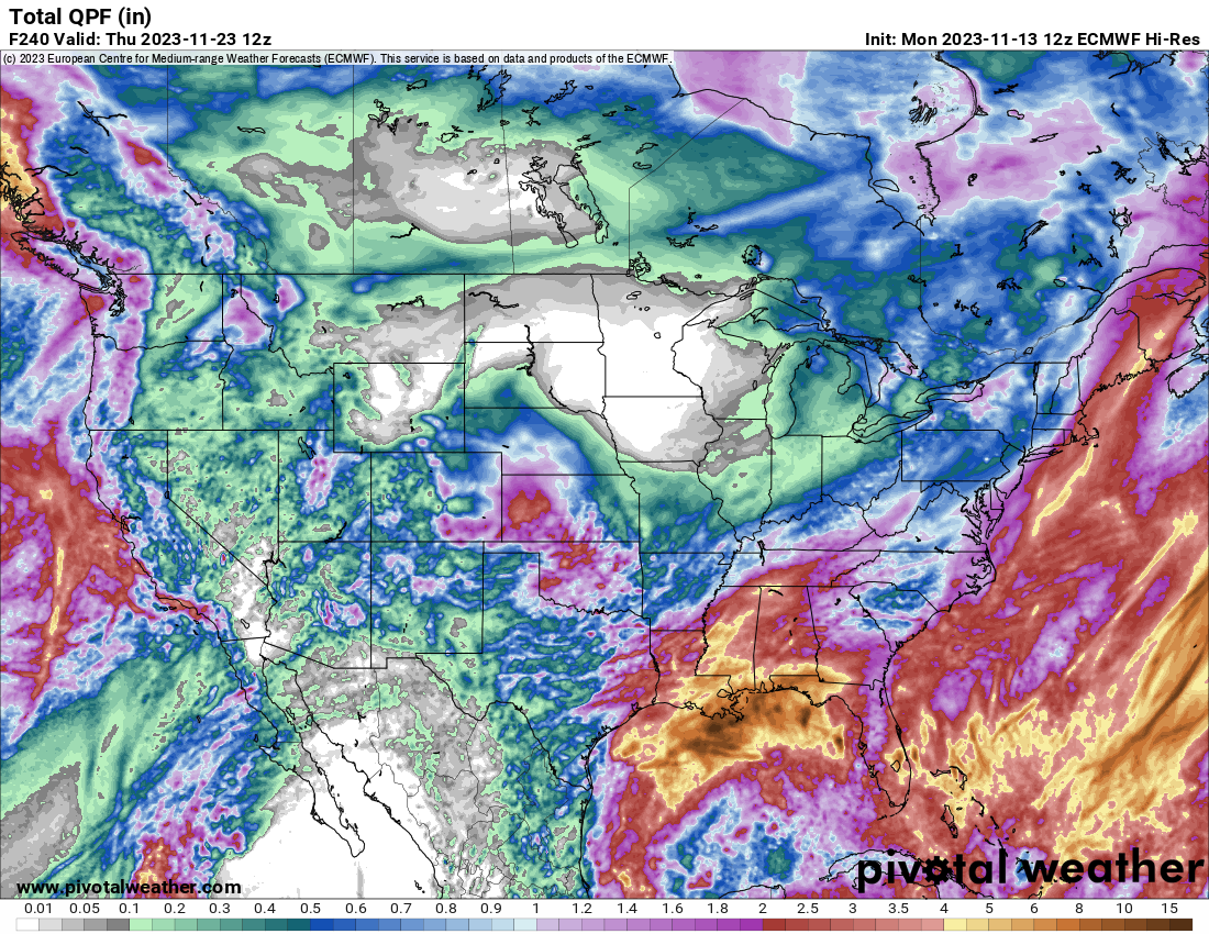
An active weather pattern over the next ten days will bring significant precipitation to many sections of the nation including the west coast, Gulf coast and northern New England. Map courtesy Pivotal Weather, ECMWF (forecast map of total precipitation amounts next ten days)
Details
Low pressure that began to take shape this weekend over the western Gulf of Mexico will continue to slide slowly to the east and it will produce significant rainfall in the region from eastern Texas to Florida where it has been quite dry in recent weeks. This system pushes off the Florida coastline by the end of the week, but it may not be done with the US east coast. Signs point to a turn to the northeast for this system which could bring it to near the Mid-Atlantic coastline by early Saturday. After that, this storm system then would have a chance of bringing rainfall to New England’s coastal sections and potentially, accumulating snow to interior sections of northern New England (e.g., western Maine). On the backside of this system, colder air will pour into the Mid-Atlantic/Northeast US this weekend riding in on strong NW winds.

The Eastern Pacific Oscillation (EPO) is headed for a big drop into negative territory which typically supports the idea of a colder-than-normal stretch of weather in the eastern states. Plot courtesy Weather Bell Analytics, ECMWF
Another section of the country will get in on some of the action in the unfolding more active weather pattern. Specifically, the west coast from California to Washington will likely receive significant rainfall from mid-week to the end of the week and accumulating snow is likely to fall across some of the interior, higher elevation locations in the western US.

The Madden-Julian Oscillation of MJO which tracks a recurring tropical disturbance in the atmosphere appears to be headed into “phases” 8 and 1 during the next ten days to two weeks and this typically favors colder-than-normal conditions across much the eastern half of the nation. Plot courtesy ECMWF (forecast of MJO shown in red)
By the first half of next week, the California storm system will push into the middle of the nation and it could end up spawning a strong storm over the south-central states. This storm could then pull to the north and produce precipitation in the Midwest and northeastern states by the middle of the week…an important travel time ahead of the Thanksgiving Day holiday. To the northwest of the storm, it looks like a widespread cold air mass will drop southeast from Canada into the northern US. This cold air outbreak may very well encompass much of the northern half of the nation by the time we get to the Turkey Day holiday on Thursday, November 23rd.
Meteorologist Paul Dorian
Arcfield
arcfieldweather.com
Follow us on Facebook, Twitter, YouTube
Video discussion: