12:00 PM | ***Low pressure to intensify rapidly next 24 hours…snow showers on Tuesday to rotate all the way down into SE PA/southern NJ…winds to become a major factor***
Paul Dorian

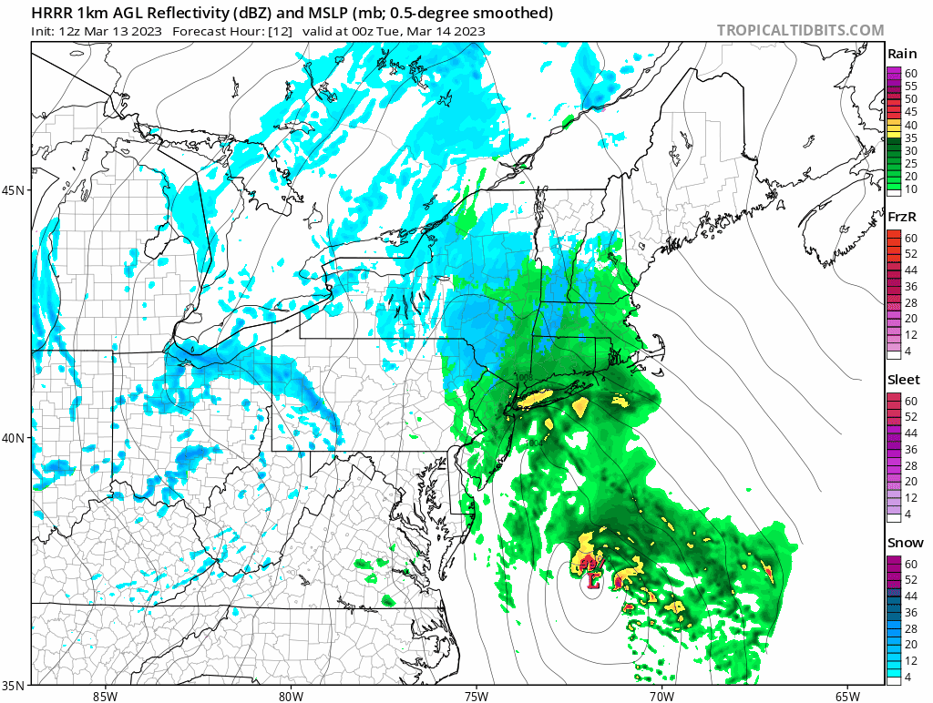
Bands of snow will rotate from northeast-to-southwest on Tuesday likely all the way down into southeastern PA and southern New Jersey as depicted here in this 24-hour loop from a high-resolution computer forecast model known as the HRRR. Maps courtesy NOAA (HRRR, hourly surface/radar reflectivity maps run from Monday evening to Tuesday evening), tropicaltidbits.com
Overview
Low pressure near the Outer Banks of North Carolina this morning will intensify rapidly during the next 24 hours and reach near the southern New England coastline by early Tuesday. An inverted trough will extend to the northwest of the low pressure center on Tuesday morning and this feature will rotate from northeast-to-southwest during the day. As a result, snow showers will tend to drop from northeast-to-southwest on Tuesday and are likely to reach all the way into southeastern PA and southern NJ. The heaviest snowfall from this storm is likely to end up extending from NE PA/NW NJ to the Hudson Valley region of NY State, central/western sections of Massachusetts/Connecticut and ultimately, up across northern New England. In addition to the snow, winds will become a major factor during this storm not only in the Northeast US, but also throughout the Mid-Atlantic region. Gusts of 50 mph are likely from late Monday night through Wednesday and can reach as high as 70 mph along coastal New England during the height of the storm…power outages are on the table.

The position of the mid-level low is critical in determining the ultimate location of heavy snow accumulations. The current expected track of this upper-level feature is likely to prevent Philly and NYC metro regions from receiving significant snowfall; however, from NE PA, NW NJ and points to the north and northeast of there, heavy snowfall is very likely. Map courtesy NOAA, tropicaltidbits.com
Details
Strong upper-level low is situated over the Great Lakes on Monday morning and will drop southeastward during the next 24 hours helping to initiate rapid intensification of low pressure now just off the North Carolina coastline (strengthening as much as 15-20 millibars in a 24-hour period). This same upper-level feature was located near the US west coast on Friday - contributed to the latest powerful storm that impacted California - and then it moved eastward over the weekend reaching the Northern Plains by Sunday afternoon.
Precipitation in the Mid-Atlantic region will be rather scattered today and for much of tonight and with temperatures generally well above-freezing in the DC-to-Philly-to-NYC corridor, anything that does fall in the I-95 corridor will be in the form of rain. Colder air will begin to wrap into the system late tonight and any rain or mixture that is falling can change to all snow in many spots by early Tuesday. Snow bands associated with the inverted trough are likely to swing from northeast-to-southwest during the day on Tuesday and can reach all the way into southeastern PA and southern New Jersey.

The “bullseye” region in terms of total snowfall with this upcoming storm is likely to include NE PA, NW NJ, upstate NY, central/western MA and CT, and all points northward from there into northern New England. Map courtesy NOAA, tropicaltidbits.com
A coating of snow on grassy surfaces is possible on Tuesday all the way into the Philly metro region with an inch or two in some of the far northern suburbs such as Upper Bucks County. Farther to the north, this does not look like a big deal for New York City as well in terms of snowfall given the expected positioning of the surface and upper-level lows – perhaps resulting in a coating to an inch or so in that metro area. Snow accumulations will rise notably, however, not too far to the north and west of the “Big Apple” with, for example, up to 6” possible across some of the higher elevations of NE PA and NW NJ. Even higher snowfall amounts of 1-2 feet and even isolated 3 feet totals can fall in the “bullseye” region of Hudson Valley region of NY State, central/western MA and northwestern CT, and northward from there into Vermont and New Hampshire (3-6 inches possible in Boston).
While accumulating snow will draw a lot of attention with this storm system, perhaps the most important factor will end up being the increasingly strong winds; especially, in the Mid-Atlantic region where snowfall will be rather limited. Wind gusts of 50 mph are certainly on the table from early Tuesday into late Wednesday throughout the Mid-Atlantic region and don’t be surprised if they reach as high as 70 mph across coastal New England during the height of the storm. Unfortunately, power outages are on the table throughout the northeastern quadrant of the nation from early Tuesday into Wednesday night. High pressure builds across the eastern states on Thursday making for a much quieter weather pattern and it’ll turn noticeably milder as well.
Meteorologist Paul Dorian
Arcfield
arcfieldweather.com
Follow us on Facebook, Twitter, YouTube
Video discussion: