10:30 AM (Wednesday) | **Storm threat continues for the east coast…strong onshore winds early this weekend with this “tropical-like” system**
Paul Dorian
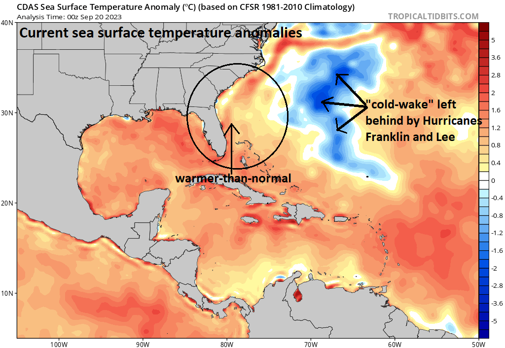
While a “cold-wake” has been left behind over the western Atlantic by the passage of Hurricanes Franklin and Lee (upwelling), waters remain abnormally warm just off the SE US coastline and this is where low pressure will form late this week. Map of sea surface temperature anomalies courtesy NOAA, tropicaltidbits.com
Overview
A storm threat continues for the late week/weekend near and along the east coast with the potential of heavy rain and strong onshore winds. Low pressure will form just off the Southeast US coastline over very warm waters of the southwestern Atlantic and likely take on “tropical” characteristics. Whether or not this system becomes classified as “tropical” remains to be seen; however, the end result could be the same with heavy rain on the table and persistent strong onshore winds; especially, for coastal sections from the Carolinas to southern New England.
Tropical moisture will feed into this system from the south and east of the low pressure center. Onshore winds will likely become quite persistent and strong from the Carolinas to southern New England. Map courtesy NOAA, tropiocaltidbits.com
Details
Typically, the latter half of the Atlantic Basin tropical season features more in the way of systems that develop relatively close to the US rather than the “long-tracking” waves that come off of Africa’s west coast such as what took place just recently with Hurricane Lee. These “nearby” tropical systems can form closer to the US in the Gulf of Mexico, Caribbean Sea or southwestern Atlantic Ocean where sea surface temperatures remain very warm and are right around 30 degrees (C). Indeed, the late week and weekend may feature such a system that forms over the abnormally warm waters of the SW Atlantic just off the Southeast US coastline. Whether or not this system is ultimately officially deemed “tropical” by NOAA’s National Hurricane Center remains to be seen. It should take on tropical characteristics as it is likely to spend a decent amount of time out over the open warm waters of the SW Atlantic.
There is the chance that winds gust into the 40-50 mph range early this weekend along coastal sections from the Carolinas to southern New England as depicted here by the 06Z GFS. Map courtesy NOAA, Weather Bell Analytics (Meteorologist Joe Bastardi, Twitter)
By the end of the week, strong high pressure at the surface will build across New England and upper-level ridging will intensify across Canada and also the western Atlantic. As a result, low pressure that forms just off the Southeast US coastline is likely to push in a general northward direction right over or near the eastern seaboard. The difference in pressure between the high pressure over New England and the intensifying low pressure system will tighten and this will raise the likelihood of strong onshore winds from the Carolinas to the northern Mid-Atlantic and potentially into southern New England as well. In fact, wind gusts of 40+ mph are on the table along coastal sections from the Carolinas to southern New England during the early part of the upcoming weekend. Rainfall may become heavy for at least the eastern half of the Mid-Atlantic region given the expected influx of moisture from the western and tropical Atlantic. Given the expected lengthy period of onshore winds (E-NE direction), coastal flooding could become an issue from the Carolinas to Mid-Atlantic and potentially up to southern New England as well.
One final note, there is still a few days to go to this weather event and big differences still exist amongst computer forecast models. One of the details that still has to be ironed out is how far inland the moisture (rain) field associated with this storm will extend on Saturday. As an example of a tough forecast at this point in time is for University Park, PA where Penn State has a night game scheduled against Iowa and that region in central PA could be on the outer fringes of the precipitation field…stay tuned.
Meteorologist Paul Dorian
Arcfield
arcfieldweather.com
Follow us on Facebook, Twitter, YouTube
Video discussion:


