11:30 AM | ***Tropical storm to be impactful along the east coast with heavy rain, strong winds, coastal flooding, rough surf…an outside chance of reaching hurricane status before landfall***
Paul Dorian

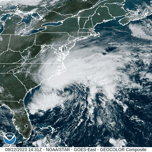
Low pressure is intensifying today over the very warm waters of the SW Atlantic Ocean. This system will take on tropical characteristics before reaching the eastern part of North Carolina early Saturday morning. As such, it should become a named tropical storm, Ophelia, by NOAA’s National Hurricane Center and it can potentially strengthen into category 1 hurricane status before making landfall. Images courtesy NOAA/GOES-East
Overview
An intensifying storm system over the southwestern Atlantic Ocean will be quite impactful during the next couple of days all the way from the Carolinas to Long Island. Heavy rain, powerful winds, beach erosion and coastal flooding are all on the table from this storm as it pushes in a general north-to-northwest direction during the next couple of days and even isolated tornadoes cannot be ruled out. This system will take on tropical characteristics as it heads towards an early Saturday landfall in eastern North Carolina - potentially intensifying into a category 1 hurricane. Later this weekend, as the storm reaches the Chesapeake Bay region, it will slow down and begin a turn from the general northward direction to northeast. It’ll likely then cross the Delaware Bay and heads toward southern New Jersey in a weakened state and its slow pace will result in rainfall across the Mid-Atlantic region all the way into later Sunday.

Low pressure is intensifying today in an area of the southwestern Atlantic Ocean that features above-normal sea surface temperatures that are close to the 30 degrees (C) mark - plenty supportive of development and intensification of a tropical system. Map courtesy of NOAA, tropicaltidbits.com
Details
The second half of the Atlantic Basin tropical season typically features more in the way of tropical systems that develop relatively close to the US rather than the “long-tracking” waves that come off Africa’s west coast such as what took place recently with Hurricane Lee. These “nearby” tropical systems can form in such regions as the Gulf of Mexico, Caribbean Sea or the southwestern Atlantic Ocean where sea surface temperatures currently are running at above-normal levels not far from 30 degrees (C). Indeed, a storm is intensifying today right over those very warm waters of the SW Atlantic Ocean and it should take on tropical characteristics later today (i.e., develops a warm core up to mid-levels of the atmosphere) as it pushes towards possible landfall early Saturday morning in eastern North Carolina. There is an outside chance that this system intensifies enough to become classified as a category 1 hurricane before it makes landfall early tomorrow (would be named “Ophelia”).

The tropical storm will take on a north-to-northwest path during the next 48 hours or so and then turn to the northeast later in the weekend as it slows down and weakens. The expected path will bring the storm system to near the Chesapeake Bay and then possibly a crossing of the Delaware Bay on its way to southern New Jersey in a weakened state. Map courtesy NOAA/National Hurricane Center
As we end the work week, strong and intensifying high pressure is shifting to eastern New England at the same time the storm of interest is intensifying off the Carolina coastline. The pressure gradient between this departing strong high pressure system to the north and the strengthening tropical storm to the south will tighten in coming hours and surface winds (onshore) will respond by intensifying; especially, along coastal sections.

Winds can gust past 50 mph along coastal sections during this weather event from the southern Mid-Atlantic region to Long Island and potentially past 60 mph along the Carolina coastline early Saturday as the storm arrives. Map courtesy ECMWF, weathermodels.com
These strengthening onshore winds (E-NE direction) will persist for an extended period of time and this is likely to result in beach erosion, rough surf, and coastal flooding at times of high tide all the way from the Carolinas to Long Island. Winds are likely to gust past 50 mph in coastal areas in the Mid-Atlantic and potentially to 60+ mph along the Carolina coastline with the arrival of the storm early Saturday.

Tropical storm will likely make landfall early Saturday morning along the coastline of eastern North Carolina. This system should take on tropical characteristics later today and would become named “Ophelia” by the National Hurricane Center. The intensifying storm has an outside chance of reaching category 1 hurricane status before making landfall on Saturday morning. Map courtesy NOAA, tropicaltidbits.com
After landfall, the storm will push northward to the Chesapeake Bay region and it’ll tend to slow down at that point as it begins a turn from a general northward direction to northeast. By early Sunday, the storm will likely continue to weaken as it crosses the Delaware Bay, and heads towards the southern part of New Jersey.
In the immediate DC-to-Philly-to-NYC corridor, rain and wind will become issues later tonight and continue through much of the weekend. As is typical with tropical systems, the rain during this event will come in “bands” and fall at varying rates with a few inches for total amounts on the table by later Sunday. There is a chance that thunderstorms mix into the picture on Saturday and Saturday night and isolated tornadoes cannot be ruled out in areas such as the Delmarva Peninsula and southeastern Virginia. Winds can gust into the 40-50 mph range in the urban areas along I-95 during this storm and 50+ mph along coastal sections of the Mid-Atlantic.
Meteorologist Paul Dorian
Arcfield
arcfieldweather.com