
11:30 AM | ****Accumulating snow in the Mid-Atlantic region on Friday and we'll have to watch for small-scale "banding"…an Arctic blast to follow for the weekend…a warming trend next week****
Paul Dorian

An impressive upper-level “vorticity” maxima will slide into the Mid-Atlantic region on Friday aiding in the intensification of low pressure near the Carolina coastline. In areas just to the north, there can be some heavier snow bands which could lead to enhanced snowfall amounts in places like southeastern PA, northern MD, northern DE, south/central NJ. Map courtesy NOAA, tropicaltidbits.com
Overview
Accumulating snow fell in the Mid-Atlantic region from Monday into Tuesday and a second such event is headed this way for the end of the work week. Snow should develop early in the day on Friday in the DC-to-Philly-to-NYC corridor as low pressure starts to intensify just off the Carolina coastline aided by vigorous support in the upper part of the atmosphere. On the heels of the late week snow event, another Arctic air mass will plunge into the eastern US from Canada and single digits lows will be possible this weekend in some suburban locations. Looking ahead, the Arctic chill will dissipate around here early next week and we’ll turn warmer-than-normal for the middle and latter parts of next week with rain likely back in the forecast.

12Z NAM (3-km high resolution version of the model) surface forecast map as of 1PM, Friday, January 19th with snow shown in blue. Map courtesy NOAA, tropicaltidbits.com
Details
A two-year “snow drought” in the DC-to-Philly-to-NYC corridor ended earlier this week with the accumulation of more than an inch of snow at the official weather stations in each of the three big cities. As it turns out, there will be two accumulating snow events this week in this same I-95 corridor region as low pressure intensifies on Friday just off the Carolina coastline. This surface system will be aided by a vigorous upper-level low pressure system that will drop southeast from the Great Lakes on Friday and into the northeastern part of the country with a couple of “vorticity” centers (circled areas on map) rotating through the large-scale trough. Those areas just to the north of the initial “vorticity” maxima on Friday will likely experience the small-scale heavier snow bands enhancing accumulation amounts in the following areas: east-central and southeastern PA, northern MD, northern DE, southern and central NJ. The low pressure system will push in an east-to-northeast direction as it amplifies during the day on Friday and should be positioned well off the coast by Friday night (i.e., a fairly quick mover). However, there will be an “inverted” trough of low pressure later Friday that will likely extend back to the coast from the surface low pressure center well out over the western Atlantic. The speed at which the low intensifies while still near the east coast and the final positioning of the upper-level “vorticity” maxima and “inverted” trough will play big roles in total snow accumulation amounts for the DC-to-Philly-to-NYC corridor - and it can be quite variable.
Snow should begin very early on Friday in the I-95 corridor and continue through much of the day. Here is my current thinking on the timing of the arrival of the snow and preliminary accumulation estimates in the DC, Philly and NYC metro regions:
Philly metro region:
Arrival time: 3-7 AM
Snowfall: 3-6 inches
DC metro region:
Arrival time: 2-6 AM
Snowfall: 1-3 inches
NYC metro region:
Arrival time: 4-8 AM
Snowfall: 2-4 inches

On the heels of the Friday snow event in the Mid-Atlantic region, another Arctic air mass will plunge into the eastern states. The core of the cold air mass relative-to-normal will likely be centered over the Carolinas and Tennessee Valley regions. Map courtesy NOAA, tropicaltidbits.com
On the heels of the storm, another Arctic air mass will plunge into the central and eastern US from Canada and temperatures this weekend can bottom out in single digits in many suburban locations of the Mid-Atlantic region. As was the case this morning (see map below), the core of the cold air mass this weekend may again become centered near the Tennessee Valley with the highest departures-from-normal in that part of the nation.
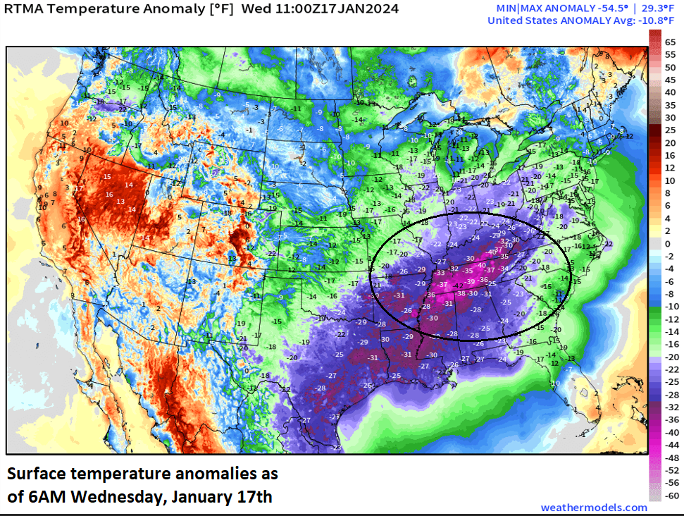
Arctic air gripped the eastern half of the nation this morning with the coldest core relative-to-normal centered over the Tennessee Valley with temperatures as much as 40 degrees below normal. Another Arctic blast invades the eastern half of the nation this weekend and the core of this next air mass may be in a pretty similar location (i.e., Tennessee Valley). Map courtesy NOAA, weathermodels.com (Dr. Ryan Maue, Twitter)
The Arctic chill in the eastern states will begin to fade away on Monday and warmer-than-normal conditions will develop across the central US on the backside of high pressure located near the east coast. The warmer-than-normal conditions will then spread to the eastern seaboard later next week and rain could even return to the forecast during the second half. Our “January thaw” will likely take us into the last couple days of the month, but February is destined to feature additional cold air outbreaks and snow threats in the central and eastern states.

A “January thaw” develops later next week across much of the eastern two-thirds of the nation. Map courtesy NOAA, tropicaltidbits.com
Stay tuned…a slight shift in the positioning of the upper-level “vorticity” maxima on Friday can cause a shift in the location of the heavier snow bands in the DC-to-Philly-to-NYC corridor.
Meteorologist Paul Dorian
Arcfield
arcfieldweather.com
Follow us on Facebook, Twitter, YouTube
Video discussion: