
1:45 PM | ***Weekend accumulating snow threat highest on northwest side of I-95…powerful storm next week to bring heavy rain, interior snows, potentially damaging wind gusts***
Paul Dorian

This surface forecast map by the 12Z Canadian model features snow (in blue) late Saturday/early Sunday across much of the Mid-Atlantic region and rain (in green, yellow) closer to the coast in places like southern New Jersey and the Delmarva Peninsula. Also, a key player in the weekend event will be a high pressure system over southeastern Canada (far upper, right) that will try to maintain cold air in the Mid-Atlantic region. Map courtesy Canadian Met Centre, tropicaltidbits.com
Overview
The active weather pattern that brought multiple heavy rain events to the Mid-Atlantic region in December continues as we begin the new year and it is likely to result in accumulating snow this weekend; especially, in areas to the north and west of Route I-95. In about a week’s time, yet another storm system is likely to feature heavy rain, interior higher elevation snows, and potentially, damaging wind gusts. A predecessor system to the weekend event can bring some rain and/or snow shower activity to the Mid-Atlantic region from later tomorrow night into early Thursday. This particular system will not be a big deal; however, it will intensify significantly once well off the Northeast US coastline and likely end up being a key player in the weekend event.
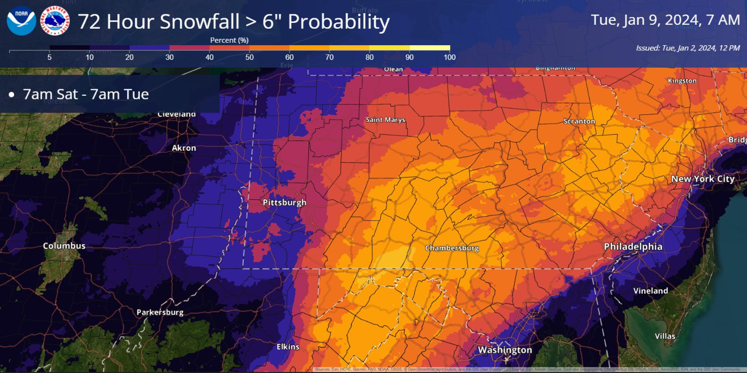
This map put out by NOAA displays the probability of > 6 inches of snow in the Mid-Atlantic region from the upcoming weekend storm system and it is based on a blend of computer forecast models. Map courtesy NOAA
Details
After the mild weather conditions of last week in the Mid-Atlantic region, more seasonal cold has arrived for this week and the overall active weather pattern that began last month will continue well into the new month. The next precipitation threat for the Mid-Atlantic region comes later tomorrow night into early Thursday in the form of rain and/or snow showers, but it should not be anything significant. The culprit for this minor event will be a pair of low pressure systems with a northern system dropping southeastward from the Great Lakes and a southern system pushing northeastward along the southeast US coastline. These two systems will “phase together” well of the Mid-Atlantic coastline and ultimately intensify into a powerhouse storm over the northwest Atlantic Ocean. In fact, this system will end up being a key player to the upcoming weekend storm system in that it will help to push cold air into the Mid-Atlantic region late in the week and then help to maintain the cold air with the development of strong high pressure over southeastern Canada.
By early Saturday, low pressure with plenty of moisture will push northeastward from the southern states and there may be a secondary reflection of low pressure headed into the northern Ohio Valley. By early Sunday, these two systems will coalesce into a one storm system off the Mid-Atlantic coastline likely resulting in accumulating snow; especially, to the north and west of Route I-95. The evolution of this storm system is still in some flux at this vantage point, but it appears the timetable of the precipitation in the Mid-Atlantic region is likely to be from mid-day/early afternoon on Saturday into early-to-mid-day on Sunday.
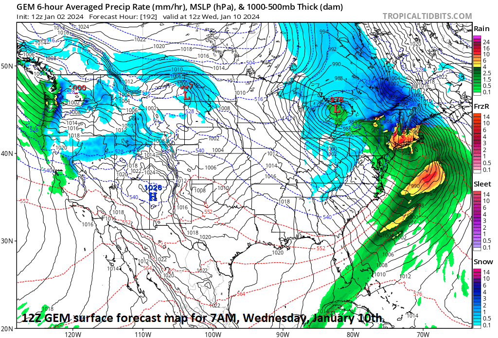
The active weather pattern will likely bring about another major storm system next week to the eastern US. In about a week’s time, this storm system could feature heavy rainfall in the Mid-Atlantic’s I-95 corridor and interior, higher elevation snows across the Northeast US. In addition, signs point to the possibility of damaging wind gusts with this storm system from next Tuesday into Wednesday; especially, along New England’s coastline. Map courtesy Canadian Met Centre, tropicaltidbits.com
Looking ahead to next week, the active weather pattern will continue with another significant storm system likely in about a week’s time (Tuesday, 1/9 – Wednesday, 1/10). Next week’s event may result in heavy rainfall along the Mid-Atlantic’s I-95 corridor with snow possible across interior, higher elevation locations of the Northeast US. In addition, even though it is a week away, there are already strong signals that winds with next week’s system could be very strong and potentially damaging; especially, along New England’s coastline.
Stay tuned…looks like quite an active couple of weeks.
Meteorologist Paul Dorian
Arcfield
arcfieldweather.com
Follow us on Facebook, Twitter, YouTube
Video discussion: