
11:00 AM | ****Weekend winter storm impacts Mid-Atlantic/Northeast US…powerhouse storm threatens with very heavy rain, interior snows, damaging winds on Tues/Wed…intense cold****
Paul Dorian

Signs continue to point to intense cold making it into the North America side of the North Pole in about ten days or so. There has already been intense cold on the other side of the pole in December (e.g., China, Korea) and - in just the last few days - Scandinavian countries such as Sweden and Finland have had temperatures not seen in many decades. Map courtesy NOAA (GFS), Pivotal Weather
Overview
The active weather pattern that began in December will continue for the foreseeable future across the eastern half of the nation. A winter storm will impact the Mid-Atlantic region and Northeast US this weekend with significant accumulating snow across interior, higher elevation sections from West Virginia to Massachusetts and a mixture of precipitation in the big cities along the DC-to-Philly-to-NYC corridor. Another storm system will impact the eastern half of the nation in the Tuesday/Wednesday time frame and this one looks like a powerhouse. It is likely to feature very heavy rainfall, interior accumulating snows and potentially damaging winds with power outages on the table in many states. If that isn’t worrisome enough for next week’s storm, throw in some snow cover from this weekend’s system and flash flooding may become a real concern next Tuesday/Wednesday in those snow-covered areas that do receive heavy rainfall.
Looking ahead, there has been plenty of intense cold in recent weeks on the other side of the North Pole (e.g., China, Scandinavia) and signs continue to point to some intense cold making its way onto the North America side in coming days.
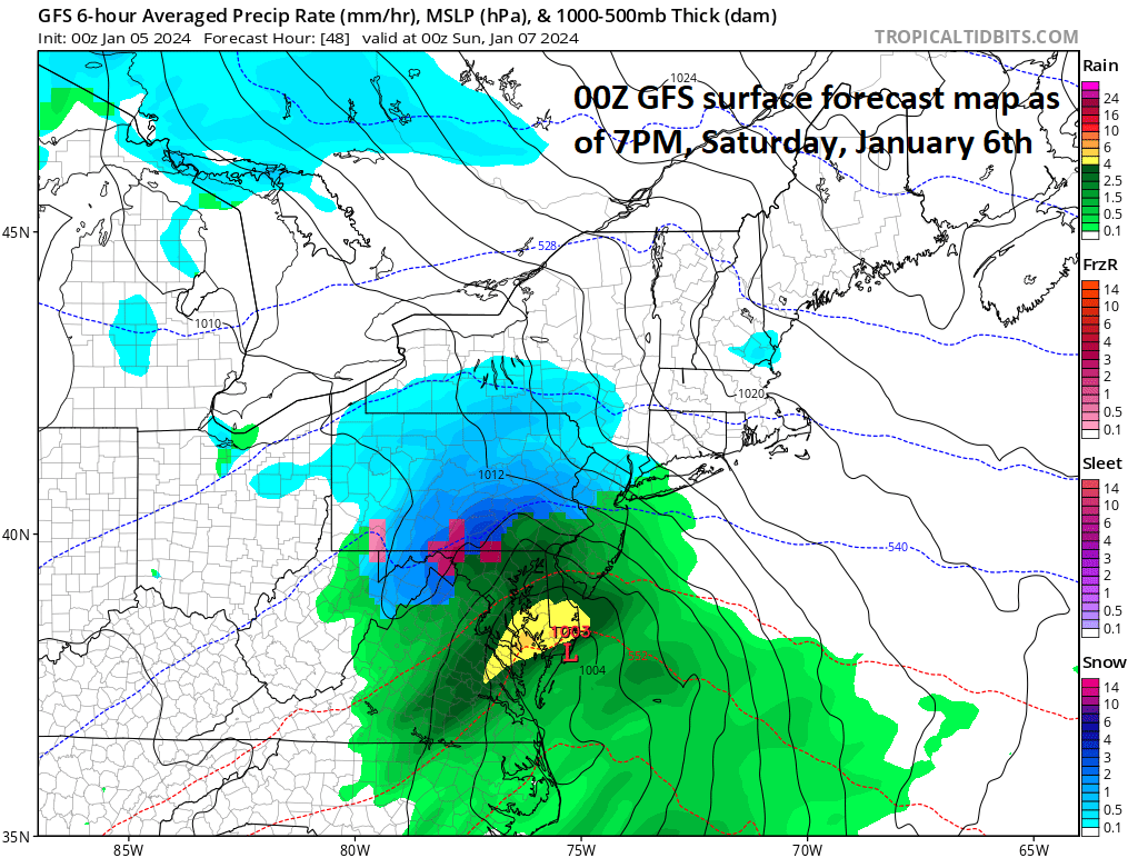
The weekend winter storm will produce the most accumulating snow across interior, higher elevation sections of the Mid-Atlantic region and Northeast US from West Virginia to Massachusetts with a mixed bag of precipitation expected in the big cities along the DC-to-Philly-to-NYC corridor. Map courtesy NOAA, tropicaltidbits.com
Weekend system
Low pressure pushes out of the southern states early this weekend and it will head in a northeast direction towards the Mid-Atlantic coastline. Another player in the weekend event will be high pressure over southeastern Canada which will help to lock in cold air for the Mid-Atlantic region; especially, across interior sections which are farther away from potential low-level warming effects of the western Atlantic Ocean. The precipitation is likely to reach the DC metro region in the early-to-mid morning hours on Saturday and it will continue to push to the north and east likely reaching Philly by late morning or mid-day and NYC by early-to-mid afternoon. In terms of precipitation type, it looks like a battle shaping up in the I-95 corridor with a mixture of snow, sleet and rain the likely result in the big cities that will put a limit in those areas on total accumulation amounts. Precipitation is likely to continue on Saturday night in the big cities as rain or a mix of rain and snow and precipitation may linger well into the day on Sunday; especially, in areas to the north of the PA/MD border. In fact, there is a chance that the “best” snow during this weekend in NYC and perhaps even as far south as Philly actually takes place on Sunday on the backside of the storm.
Snowfall estimates in DC-to-Philly-to-NYC corridor:
Coating to 1 inch in DC metro, 1-3” in far N/W suburbs; start time early-to-mid morning
Coating to 2 inches in Philly metro; 2-4 inches in far N/W suburbs; start time late morning-to-mid-day
1-3 inches in NYC metro; 3-6 inches in far N/W suburbs; start time early-to-mid afternoon

The storm system next Tuesday/Wednesday will become a powerhouse with very heavy rainfall, interior snow, and potentially damaging winds with power outages a possibility in many states. Map courtesy NOAA, tropicaltidbits.com
Tuesday/Wednesday massive storm
Next week’s storm looks massive and it will have a big impact on a large part of the nation from the Midwest/Great Lakes to the Mid-Atlantic/Northeast US. Low pressure will push towards the Great Lakes by Tuesday and deepen significantly. The favored scenario at this vantage point is for heavy rainfall to develop near and along coastal sections of the eastern US with accumulating snow likely in the interior, higher elevation locations of the Mid-Atlantic/Northeast US. However, it is worth mentioning that given the developing high-latitude blocking pattern aloft and the possibility of a secondary low pressure system near the east coast, there is a chance that there is an initial outburst of snow in some of the I-95 corridor where rain would still end up being the predominate precipitation type. If all that isn’t worrisome enough for next week’s storm, throw in some snow cover from this weekend’s system and flash flooding may become a real concern next Tuesday/Wednesday in those snow-covered areas that do receive heavy rainfall.
One other very important factor to mention with respect to next week’s storm is that there may be damaging wind gusts and power outages are a real possibility in many states. The pressure difference between the very strong low pressure system over the Midwest/Great Lakes and high pressure over southeastern Canada will be quite large raising the chance for strong and potentially damaging winds; especially, along coastal sections. The threat for damaging winds in the Mid-Atlantic region and North US will likely come both on the front side of the storm on Tuesday (S-SE wind direction) and on the backside on Wednesday (W-NW wind direction).

High-latitude blocking pattern is likely to set up later this month over Greenland with much higher than normal 500 mb heights expected (orange, brown) while a large-scale upper-level trough of low pressure (blue) sets up over the northern US. This type of upper-air pattern generally favors colder-than-normal conditions across much of the US. Map courtesy ECMWF, weathermodels.com
Intense cold
One final note of interest, a stratospheric warming event that began in November has contributed to the unleashing of some brutally cold air masses into the middle and high latitudes from the polar region. A few weeks ago, China recorded its lowest temperatures in many decades and just in the last couple of days, Scandinavian countries such as Sweden and Finland have seen some of their coldest temperatures since last century. Some examples…Kvikkjokk suffers a daily 'high' of just -42.3 C -- a new “low-max” in the books dating back to 1917. Oslo-Blindern posts its coldest temp since January 1987 (-23.1 C). With Bjørnholt, north of Oslo, setting the area's lowest temperature ever (-31.1 C).
There continue to be signs that intense cold air will make its way onto the North America side of the North Pole in coming days. In fact, recent forecast model runs show some intense cold air pushing southward through western Canada and into the western and central parts of the US in about seven-to-ten days…something to closely monitor in coming days; especially, with respect to its ability to drive south and east all the way to the eastern seaboard.

Two teleconnection indices known as the Arctic Oscillation (top) and North Atlantic Oscillation (bottom) support the idea of a strong high-latitude blocking pattern over Greenland later in January as they both drop deeply into negative territory which is generally well correlated with that kind of upper-air pattern. Plots courtesy ECMWF, weathermodels.com
Buckle up…it looks like quite an active couple of weeks.
Meteorologist Paul Dorian
Arcfield
arcfieldweather.com