8:00 AM (Sunday) | ****Rain-to-snow scenario in much of the Mid-Atlantic from later Monday night into Tuesday…accumulations across PA, central/northern NJ, NYC****
Paul Dorian

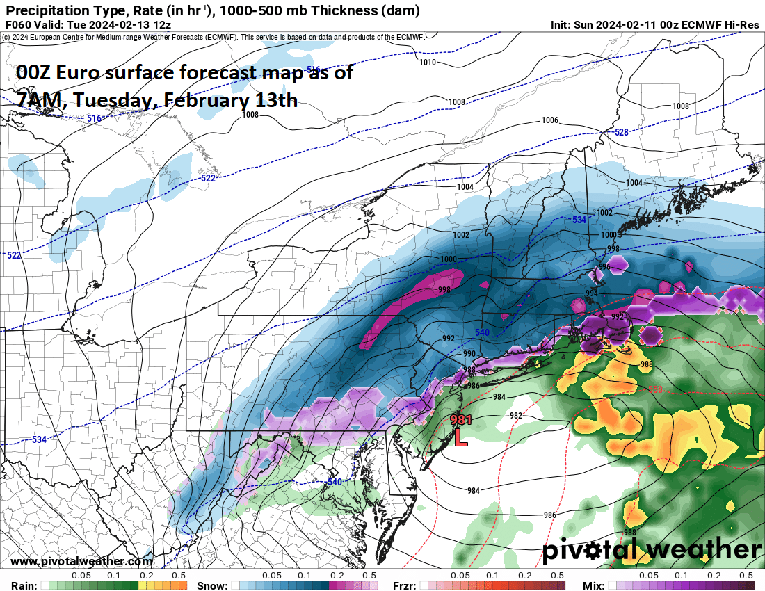
Colder air will wrap into the upcoming system from the north and west causing a changeover of rain to snow in most areas north of the PA/MD border, across central and northern NJ and New York City. Map courtesy ECMWF, Pivotal Weather
Overview
The last two days were quite mild across the Mid-Atlantic region with highs reaching the upper 50’s in many areas and even the lower 60’s in a few spots. A cold front pushed through late Saturday, but there will not be any truly cold air mass following it for the beginning of the new work week. Later Monday, an intensifying storm system will push towards the Mid-Atlantic region and with no cold air established, rain will fall initially in the DC-to-Philly-to-NYC corridor. As the storm pushes to the Mid-Atlantic coastline and intensifies, colder air will wrap into the system from the north and west later Monday night into early Tuesday. As a result, a changeover to snow is likely across Pennsylvania, central/northern NJ, and in the New York City metro region with accumulations on Tuesday morning and there will be an impact on the AM commute in many spots. A changeover to snow is less likely across the DC metro region and southern New Jersey, but even there some sleet and snow is likely to fall early Tuesday.

The 00Z EPS snowfall map highlights well the expected “bullseye” region from central/NE PA to interior New York State to southern New England. Map courtesy ECMWF, Weather Bell Analytics
Details
A couple of very mild days took place in the Mid-Atlantic region on Friday and Saturday with temperatures peaking at 60+ degrees in, for example, like Washington, D.C. despite mostly cloudy skies. A cold front pushed through late Saturday and though it will turn cooler behind it on Sunday, temperatures will remain at relatively mild levels going into the new work week.
On Monday, low pressure will push northeastward out of the Tennessee Valley to around West Virginia and then transfer to a coastal low near the Delmarva Peninsula that intensifies before heading out-to-sea in and east-to-northeast fashion. With little in the way of cold air established upon the arrival of the storm’s large moisture field, rain is likely to break out in the I-95 corridor late Monday, but colder air will be posed just to the north and west. As the storm near the coast and intensifies on Monday night, colder air to the north and west will get wrapped into the system and the rain is going to change to snow in much of PA, central/northern NJ and NYC. The “bullseye” region in terms of snowfall for this upcoming storm where 6-12 inches can accumulate appears to be from central and northeastern PA to interior New York State to southern New England (e.g., State College, Poconos, Poughkeepsie, Pittsfield, Boston).

The upcoming storm comes at the front-end of a pattern change to colder across the central and eastern US where temperatures should average below-normal in this 5-day period from 17 Feb to 22 Feb. Map courtesy ECMWF, tropicaltidbits.com
Preliminary snowfall estimates are as follows for the DC-to-Philly-to-NYC corridor:
DC: a coating to an inch or two
Philly: 2-5 inches with the higher amounts across the far northern suburbs (e.g., Upper Bucks)
NYC: 4-8 inches with the higher amounts in the northern and western suburbs
Meteorologist Paul Dorian
Arcfield
arcfieldweather.com